
Małe Ciche
| Małe Ciche | |||
|---|---|---|---|
 Help on coat of arms |
|
||
| Basic data | |||
| State : | Poland | ||
| Voivodeship : | Lesser Poland | ||
| Powiat : | Tatrzański | ||
| Gmina : | Poronin | ||
| Geographic location : | 49 ° 18 ' N , 20 ° 4' E | ||
| Height : | 830 to 860 m npm | ||
| Residents : | 850 | ||
| Telephone code : | (+48) 18 | ||
| License plate : | KTT | ||
| Economy and Transport | |||
| Street : | Oswald-Balzer-Weg | ||
| Next international airport : | Krakow-Balice | ||
| administration | |||
| Website : | www.maleciche.pl | ||

Małe Ciche is a village in the rural commune of Poronin in the powiat Tatrzański in the Lesser Poland Voivodeship in southern Poland in the historical Podhale region . It is located on the Filipczański Potok mountain stream and the Oswald-Balzer-Weg panoramic road . The village is located in the Pogórze Bukowińskie mountain range on the western slopes of about 1100 m above sea level. NHN lying Wierch Zgorzelisko and Zadni Wierch about five kilometers south of Poronin and about three kilometers east of Murzasichle and about five kilometers east of Zakopane . It is a ski resort at the foot of the High Tatras with a larger ski area.
Attractions
The 20th century Zakopane style wooden church of St. Joseph is administered by the Dominicans. The place borders on the Tatra National Park in the south . Parts of the municipality are located in the High Tatras, especially the Dolina Filipka valley . In a start ▬ blue marked trail about Wiktorówki to the pasture Rusinowa Polana leads.
tourism
The place name Małe Ciche can be translated as little still . In fact, Małe Ciche is quieter than the neighboring ski resorts of Zakopane or Bukowina Tatrzańska . The tourist infrastructure is nonetheless well developed.
Winter sports
The ski area of the same name operates in Małe Ciche . There are also other smaller lifts.
gallery

Wooden church

View from the Rusinowa Polana

Alpine farming
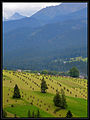
Alpine farming

Forest in the valley


Web links
Bustryk | Małe Ciche | Murzasichle | Nowe Bystre | Poronin | Search | Ząb