Makati
|
City of Makati Lungsod ng Makati |
||
| Location of Makati in the Makati City Province | ||
|---|---|---|

|
||
| Basic data | ||
| Region : | Metro Manila | |
| Province : | does not belong to any province | |
| Barangays : | 33 | |
| District: | 1st and 2nd district of Makati City | |
| PSGC : | 137602000 | |
| Income class : | 1st income bracket | |
| Households : | 98,225 May 1, 2000 census
|
|
| Population : | 582,602 August 1, 2015 census
|
|
| Population density : | 21,294 inhabitants per km² | |
| Area : | 27.36 km² | |
| Coordinates : | 14 ° 33 ' N , 121 ° 2' E | |
| Postal code : | 1200-1239 | |
| Area code : | +63 2 | |
| Mayor : | Abigail Binay-Campos | |
| Website: | www.makati.gov.ph | |
| Geographical location in the Philippines | ||
|
|
||
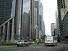
Makati (officially: City of Makati ; Filipino : Lungsod ng Makati ) is a major city in the Philippines . It is located in the center of the metropolitan area of Metro Manila and has a population of 582,602 (census August 1, 2015). Makati is considered to be the economic and financial center of the Philippines. In addition to the two Philippine stock exchanges, Philippine Stock Exchange (PSE) and Philippine Dealing Exchange (PDEx), many banks, such as Metrobank , and other companies are also located here. The embassies of Germany, Austria and Switzerland are also in Makati. The FEU-Makati campus of Far Eastern University is located in the community .
The northern border of Makatis is formed by the Pasig River , with the city of Mandaluyong on the opposite bank of the river. To the east, Makati is bordered by Pasig City and the community of Pateros , and further south and west, the cities of Taguig , Pasay and Manila complete the circle.
The name Makati has its origin in the word kati , the Tagali word for tide , and refers to the changing tides in the adjacent Pasig River. The area was inhabited by Malays as early as the 12th century, but the expansion of settlement only took place under Spanish influence from the 16th century. During the Spanish era the city was sometimes called San Pedro de Macati .
Today's main streets Ayala Avenue and Paseo de Roxas formed the runways of “Nielson Field” airport until 1948, before Manilas airport was relocated to Parañaque City .
Today Makati is the most modern developed city in the country.
Barangays
The city of Makati is politically divided into 33 barangays .
|
|
|
|


