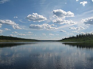
Marcha (Wiljui)
|
Marcha Марха |
||
| Data | ||
| Water code | RU : 18030800412117400016906 | |
| location | Sakha Republic ( Russia ) | |
| River system | Lena | |
| Drain over | Wiljui → Lena → Arctic Ocean | |
| source |
Wiljui Plateau 66 ° 9 ′ 1 ″ N , 111 ° 19 ′ 9 ″ E |
|
| Source height | approx. 700 m | |
| muzzle |
Wiljui coordinates: 63 ° 27 ′ 59 " N , 118 ° 54 ′ 11" E 63 ° 27 ′ 59 " N , 118 ° 54 ′ 11" E |
|
| Mouth height | 100 m | |
| Height difference | approx. 600 m | |
| Bottom slope | approx. 0.51 ‰ | |
| length | 1181 km | |
| Catchment area | 99,000 km² | |
| Discharge at the Malyukay A Eo gauge: 89,600 km² Location: 159 km above the mouth |
MQ 1938/1994 Mq 1938/1994 |
405 m³ / s 4.5 l / (s km²) |
| Drain |
MQ MHQ |
405 m³ / s 7630 m³ / s |
| Left tributaries | Daldyn | |
| Right tributaries | Morkoka | |
| Navigable | from the Morkoka estuary | |
|
Course of the Marcha (Марха) in the catchment area of the Wiljui |
||
The Marcha ( Russian Марха ) is a 1181 km long left tributary of the Wiljui in Siberia ( Russia , Asia ). It belongs to the river system of the Lena , but is not to be confused with the southern flowing Marcha of the same name, shorter and flowing directly into the Lena .
course
The Marcha rises about 700 m above sea level in the eastern part of the Wiljuiplateau belonging to the Central Siberian Mountains , a little below the Arctic Circle . It flows through this mountainous country mainly in southeastern directions and meandering in wide arches , sometimes deeply and relatively steeply cut into the surrounding plateau, always on the territory of the autonomous Republic of Sakha (Yakutia) .
About 300 kilometers above its mouth, the Marcha reaches the Central Yakut Plain and finally flows below the village of Scharchan into the only slightly larger Wiljui ( 100 m above sea level; between Nyurba and Wiljuisk ). Near the mouth, the Marcha is almost 500 meters wide, three meters deep, and the flow velocity is 0.7 m / s.
Hydrography
The catchment area of the Marcha covers 99,000 km². The most important tributary is the Morkoka from the right .
The Marcha freezes between late September / early October and late May / early June. During this time it freezes through to the bottom in the lower reaches for up to 150 days, and in the upper reaches for over 200 days. In addition to the spring floods during the snowmelt, there are also shorter, precipitation-dependent floods in summer or early autumn. The mean monthly water flow near the mouth is 405 m³ / s, with a maximum of 7630 m³ / s in June.
Infrastructure and economy
The Marcha is navigable from the confluence of the Morkoka, for smaller vessels already from the mouth of the Daldyn in the upper middle reaches, but is only used to a limited extent for inland navigation due to the short navigation period.
Some of the Yakutian diamond deposits were discovered especially in the area of the upper reaches ; in this area is the settlement of Aichal , further north the city of Udatschny . About 15 kilometers from its source, a reservoir was created on the Marcha northwest of Aichal for mining purposes, including several small natural lakes. The Lensk - Mirny- Aichal or -Udatschny road crosses the Marcha about 45 kilometers south-east of Aichal with the only bridge over the river.
The mountainous terrain through which the Marcha flows is practically uninhabited; only on the lower reaches in the area of the Central Yakutian lowlands there are some villages again, some directly on the river, some a few kilometers away (Malykai, Byssytta, Engolscha, Chatyn-Syssy, Mar), but no cities. At Scharchan, eight kilometers above the mouth, there is a ferry connection via the Marcha along the unpaved road Yakutsk- Wiljuisk-Nyurba- Suntar, which follows the Wiljui .


