Maringá
| Município de Maringá "Cidade Verde"
Maringá
"Cidade Canção" |
|||
|---|---|---|---|
|
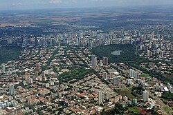
Aerial view
|
|||
|
|
|||
| Coordinates | 23 ° 26 ′ S , 51 ° 56 ′ W | ||
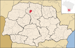
 Location of the municipality in the state of Paraná Location of the municipality in the state of Paraná
|
|||
| Symbols | |||
|
|||
| founding | May 10, 1947 (legal) (age 73), February 14, 1951 (effective) (age 69) |
||
| Basic data | |||
| Country | Brazil | ||
| State | Paraná | ||
| ISO 3166-2 | BR-PR | ||
| Metropolitan area | Maringá | ||
| structure | 3 districts | ||
| height | 515 m | ||
| climate | tropical, cfb | ||
| surface | 487 km² | ||
| Residents | 357,077 (2010) | ||
| density | 733.2 Ew. / km² | ||
| estimate | 423,666 (July 1, 2019) | ||
| Parish code | IBGE : 4115200 | ||
| Post Code | 87000-000 to 87109-999 | ||
| Telephone code | (+55) 44 | ||
| Time zone | UTC −3 | ||
| Website | maringa.pr (Brazilian Portuguese) | ||
| politics | |||
| City Prefect | Ulisses Maia (2017-2020) | ||
| Political party | PDT | ||
| Culture | |||
| Patron saint | Mother of God as Nossa Senhora da Glória | ||
| economy | |||
| GDP | 16,121,079 thousand R $ 39,996 R $ per person (2016) |
||
| HDI | 0.808 (very high) (2010) | ||
Maringá , officially Portuguese Município de Maringá , is a city in the Brazilian state Paraná of the Região Sul . It was founded on May 10, 1947 and built according to a general development plan by Jorge de Macedo Vieira. It was named after a Brazilian hit of the same name.
It is the seat of the Maringá Metropolitan Region, founded in 1998 . The distance to the capital Curitiba is 436 km.
Maringá had 357,077 inhabitants in the 2010 census, this Maringa was estimated at 423,666 people on July 1, 2019, who live in an area of around 487 km². It is strongly influenced by Japanese, Italian, German, Portuguese, Polish, Spanish, Ukrainian, Arab and Jewish immigrants.
It is known as the “Green City” and has the nickname “City of Song”. Today Maringá is a commercial and service center. Agriculture is still of fundamental importance for Maringá, but is still declining, it is fanned out into the cultivation of coffee, maize, wheat, cotton, the fiber plant ramie , beans, peanuts, rice, sugar cane and especially soybeans.
geography
Surrounding communities are Angulo , Astorga and Iguaraçu in the north, Floresta in the south , Sarandi , Marialva in the east , Paiçandu and Mandaguaçu in the west .
The biome is Mata Atlântica . It lies on the third Paranaian plateau ( Terceiro Planalto Paranaense ), the soil is fertile Terra Roxa .
climate
The community has a tropical temperate climate, Cfb according to the Köppen and Geiger climate classification . The average temperature is 17.7 ° C. The average rainfall is 1276 mm per year.
| Jan | Feb | Mar | Apr | May | Jun | Jul | Aug | Sep | Oct | Nov | Dec | |||
| Temperature ( ° C ) | 20.9 | 20.6 | 19.4 | 18.5 | 15.0 | 13.3 | 14.3 | 15.6 | 17.3 | 18.5 | 18.5 | 20.4 | O | 17.7 |
| Precipitation ( mm ) | 162 | 142 | 117 | 92 | 97 | 85 | 56 | 45 | 82 | 140 | 98 | 160 | Σ | 1276 |
Local government
The executive rests with the city prefect (mayor). In the 2016 local elections , Ulisses Maia des Partido Democrático Trabalhista (PDT) was elected city prefect for the 2017-2020 term.
The legislature lies with a 19-member elected city council, the vereadores of the Câmara de Vereadores.
Since 1968 the municipality has been divided into three administrative districts: Distrito de Maringá (municipal seat ), Distrito de Floriano and Distrito de Iguatemi . Within the actual urban region there are 75 smaller zones and city districts.
Population development
On July 18, 1976, a "black frost" occurred, the geada negra , which destroyed the entire coffee plantation in Paraná; two-thirds of the rural population fled to the urban region or moved away. Over 98% of the population is concentrated in the city, less than 2% live in the countryside within the 487 km² municipal area.
| year | Residents | city | country |
|---|---|---|---|
| 1950 | 38,588 | ||
| 1960 | 104.131 | 47,592 | 56,539 |
| 1970 | 121,374 | 99,898 | 21,476 |
| 1980 | 168,232 | 160,652 | 7,580 |
| 1991 | 240.292 | 234.079 | 6.213 |
| 2000 | 288,653 | 283,978 | 4,675 |
| 2010 | 357.117 | 349.120 | 7,997 |
| 2019 | 423,666 | ? | ? |
 |
|||
Source: IBGE (2011)
Ethnic composition
Ethnic groups according to the statistical classification of the IBGE (as of 2000 with 288,653, as of 2010 with 357,117 inhabitants):
| group | Share 2000 |
Share 2010 |
annotation |
|---|---|---|---|
| Brancos | 220.864 | 253.161 | Whites, descendants of Europeans |
| Pardos | 48,651 | 78,662 | Mixed races, mulattos , mestizos |
| Pretus | 7,839 | 11,720 | black |
| Amarelos | 9,641 | 12,999 | Asians |
| Indigenous people | 549 | 535 | indigenous population |
| without specification | 1.109 | - |
Average income and standard of living
The monthly average income in 2017 was a factor of 2.7 of the Brazilian minimum wage ( Salário mínimo ) of R $ 880.00 (income converted for 2019: around € 538 per month). The Human Development Index (HDI) is rated very high at 0.808 for 2010.
In 2017, 193,689 people or 47.6% of the population were registered as permanently employed; in 2010, 26.1% of the population had an income of half the minimum wage.
| HDI | ||||
|---|---|---|---|---|
| year | Points | |||
| 1991 | 0.608 | |||
| 2000 | 0.740 | |||
| 2010 | 0.808 | |||
The gross national product per capita in 2016 was R $ 39,996.43, the gross national product of the municipality was 16,121,079.49 × R $ thousand in 2016. In terms of economic power, it ranks 5th among the 399 municipalities in the state of Paraná and 55th among the 5570 municipalities in Brazil.
Education and Research
In Maringá is the Universidade Estadual de Maringá and the Centro Universitário de Maringá (Cesumar) as the most important higher education institutions.
Illiteracy rate
Maringá had an illiteracy rate of 12% in 1991 (including incomplete primary schooling), which had already fallen to a low 4.1% in the 2010 census. Around 18.6% of the population in 2010 were children and adolescents up to the age of 15.
| Illiteracy rate | ||||
|---|---|---|---|---|
| year | percent | |||
| 1991 | 12.00 | |||
| 2000 | 7.00 | |||
| 2010 | 4.09 | |||
Attractions
The main tourist points in Maringá are:
- the Cathedral of Maringá ( Catedral Basílica Menor de Nossa Senhora da Glória ), completed in 1972, which with 124 meters is one of the twenty tallest churches in the world and the tallest church in South America
- two parks worth seeing: Parque do Ingá and Parque das Grevíleas.
sons and daughters of the town
- Sônia Braga (born 1950), actress
- Edmar Peron (* 1965), Catholic bishop
- Sérgio Moro (* 1972), federal judge and minister of justice
- Alessandro Santos , "Alex" (* 1977), football player
- Renato Rui (* 1979), handball player
- Natália Falavigna (* 1984), Taekwondoin
- Marcelo Rodrigo Xavier (* 1988), football player
- Marcelo Cirino (* 1992), football player
literature
- Caderno estatístico Munícipio de Maringá. (PDF) Instituto Paranaense de Desenvolvimento Econômico e Social - IPARDES, Curitiba, November 2019(Brazilian Portuguese).
Web links
- City Prefecture website , Prefeirua Municipal (Brazilian Portuguese)
- City Council website , Câmara Municipal (Brazilian Portuguese)
Individual evidence
- ↑ a b c Maringá - Panorama. In: cidades.ibge.gov.br. IBGE , accessed November 29, 2019 (Brazilian Portuguese).
- ^ Histórico do Município. In: maringa.pr.gov.br. Maringá Turística, accessed November 29, 2019 (Brazilian Portuguese).
- ↑ Maringa climate: average temperature, weather by month, Maringa weather averages - Climate-Data.org. In: de.climate-data.org. Retrieved November 29, 2019 .
- ↑ Ulisses Maia 12 (Prefeito). In: todapolitica.com. Eleições 2016, accessed November 29, 2019 (Brazilian Portuguese).
- ^ A b Atlas do Desenvolvimento Humao no Brasil: Maringá, PR . Retrieved November 29, 2019 (Brazilian Portuguese)
- ↑ Censos demográficos do IBGE (1872-2010). Evolução da divisão territorial do Brasil 1872–2010 , p. 232. (Online; PDF; 125.3 MB)
- ↑ IBGE : Sistema IBGE de Recuperação Automática - SIDRA: Tabela 2093. Retrieved on November 29, 2019 (Portuguese, database query, search terms Maringá (PR) and Cor ou raça).
- ↑ Maringá - Panorama - Trabalho e rendimento. In: cidades.ibge.gov.br. IBGE , accessed November 29, 2019 (Brazilian Portuguese).
- ↑ Maringá - Produto Interno Bruto dos Municipios. In: cidades.ibge.gov.br. IBGE , accessed November 29, 2019 (Brazilian Portuguese).


