
Montiglio Monferrato
| Montiglio Monferrato | ||
|---|---|---|

|
|
|
| Country | Italy | |
| region | Piedmont | |
| province | Asti (AT) | |
| Coordinates | 45 ° 4 ' N , 8 ° 6' E | |
| height | 321 m slm | |
| surface | 27.00 km² | |
| Residents | 1,585 (Dec. 31, 2019) | |
| Population density | 59 inhabitants / km² | |
| Post Code | 14026 | |
| prefix | 0141 | |
| ISTAT number | 005121 | |
| Popular name | Montigliesi | |
| Patron saint | San Lorenzo | |
| Website | Montiglio Monferrato | |
 Castle of Montiglio Monferrato |
||

Montiglio Monferrato is a municipality with 1585 inhabitants (as of December 31, 2019) in the Italian province of Asti (AT), Piedmont region .
The neighboring communities are Cocconato , Cunico , Murisengo , Piovà Massaia , Robella , Montechiaro d'Asti , Tonco , Villa San Secondo and Villadeati .
geography
The municipality covers an area of 26 km² .
Culinary specialties
In Montiglio Monferrato, vines of the Barbera variety are grown for the Barbera d'Asti , a red wine with DOCG status, as well as for the Barbera del Monferrato .
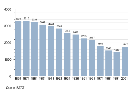
Population development
Attractions
Instead of an older predecessor building, the Castello Borsarelli from the 15th century rises above the village , which has now been converted into a residential building.
Outside the village is the richly decorated church of San Lorenzo from the 12th century, both inside and out.

Pieve San Lorenzo
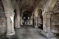
Church interior
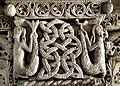
detail


Web links
- Homepage of the municipality (Italian)
Individual evidence
- ↑ Statistiche demografiche ISTAT. Monthly population statistics of the Istituto Nazionale di Statistica , as of December 31 of 2019.

Agliano Terme | Albugnano | Antignano | Aramengo | Asti | Azzano d'Asti | Baldichieri d'Asti | Belveglio | Berzano di San Pietro | Bruno | Bubbio | Buttigliera d'Asti | Calamandrana | Calliano | Calosso | Camerano Casasco | Canelli | Cantarana | Capriglio | Casorzo | Cassinasco | Castagnole Monferrato | Castagnole delle Lanze | Castel Boglione | Castel Rocchero | Castell'Alfero | Castellero | Castelletto Molina | Castello di Annone | Castelnuovo Belbo | Castelnuovo Calcea | Castelnuovo Don Bosco | Cellarengo | Celle Enomondo | Cerreto d'Asti | Cerro Tanaro | Cessole | Chiusano d'Asti | Cinaglio | Cisterna d'Asti | Coazzolo | Cocconato | Corsione | Cortandone | Cortanze | Cortazzone | Cortiglione | Cossombrato | Costigliole d'Asti | Cunico | Dusino San Michele | Ferrere | Fontanile | Frinco | Grana | Grazzano Badoglio | Incisa Scapaccino | Isola d'Asti | Loazzolo | Maranzana | Maretto | Moasca | Mombaldone | Mombaruzzo | Mombercelli | Monale | Monastero Bormida | Moncalvo | Moncucco Torinese | Mongardino | Montabone | Montafia | Montaldo Scarampi | Montechiaro d'Asti | Montegrosso d'Asti | Montemagno | Montiglio Monferrato | Moransengo | Nice Monferrato | Olmo Gentile | Passerano Marmorito | Penango | Piea | Pino d'Asti | Piovà Massaia | Portacomaro | Quaranti | Refrancore | Revigliasco d'Asti | Roatto | Robella | Rocca d'Arazzo | Roccaverano | Rocchetta Palafea | Rocchetta Tanaro | San Damiano d'Asti | San Giorgio Scarampi | San Martino Alfieri | San Marzano Oliveto | San Paolo Solbrito | Scurzolengo | Serole | Sessame | Settime | Soglio | Tigliole | Tonco | Tonengo | Vaglio Serra | Valfenera | Vesime | Viale | Viarigi | Vigliano d'Asti | Villa San Secondo | Villafranca d'Asti | Villanova d'Asti | Vinchio