
Moors south of Schönheide
|
Moors south of Schönheide
|
||
.jpg) In the Baumgärtels pines |
||
| location | Schönheide , Saxony , Germany | |
| surface | 27.83 hectares | |
| Identifier | C 101 | |
| WDPA ID | 555560773 | |
| Natura 2000 ID | 5441-303 | |
| FFH area | 27.83 hectares | |
| Geographical location | 50 ° 30 ' N , 12 ° 31' E | |
|
||
| Sea level | from 650 m to 710 m | |
| Setup date | 2013 | |
| administration | Erzgebirgskreis | |

The Moore nature reserve south of Schönheide is a “complex of species-rich montane grassland communities such as grass grass, mountain and wet meadows, some of which are closely interlinked like a mosaic. Furthermore, there are dwarf shrub heaths as well as bog areas and bog forests of the most varied forms according to the hydrological and geological conditions ”. A moor birch moor forest with moor pines (Pinus rotundata) stands on the remaining bog that has not been mined .
location
The nature reserve is located on the southern slope of the Baumannsberg mountain ( 725.5 m above sea level ) and extends from a height of about 710 m above sea level. NN at its highest point up to a height of about 658 m above sea level. NN . It is largely part of the after Directive 92/43 / EEC (Fauna and Habitats Directive) (referred to as "the Habitats Directive") designated Natura 2000 -area mountain meadows to Schönheide and Stützengrün . In its southeastern edge area, it protrudes slightly beyond the FFH area. Its northern border is formed by the Fichzigweg marked on maps and its southern border by the Rautenkranzer Weg, which is not marked on maps, until it meets the path that is called "Hammergockel" on maps. In the area there are shallow hollows with a slope to the south of different slopes of the slope. In terms of altitude, the area belongs to the middle layers of the Ore Mountains with an annual average temperature of 5.5 ° to 7.0 °. According to the natural map of Saxony, it lies in the mesogeochore "Schönheider plateau" and belongs to the microgeochore "Schönheider Kuppengebiet". A brook flows through the area to the Zwickauer Mulde, which rises on its northern edge and was nameless on maps until the end of the 20th century, in the report by RANA - Office for Ecology and Nature Conservation as "Purichbächel" and in the topographic map 1: 10,000 No. 5541-NW-Wilzschhaus as well as in the water balance portal of Saxony as "Hochmoorbächel". This brook used to be called "Geyer Seiffen Bach", as early as 1792 in sheet 196 of the miles sheets of Saxony , and sheet 195 of the Berlin copy from 1791 of this map also contains the same name for this brook. On the western and southern edge of the area, the forests that reach as far as the Zwickauer Mulde begin, in which the Upper Keilberg ( 689.1 m above sea level ) and the Lower Keilberg ( 686 m above sea level ) lie as higher elevations . Between these lies the mountain Hammerkogel ( 686.6 m above sea level ) to the west of the forest road leading to the Mulde, which is entered on maps as "Hammergockel" .
Geologically, the protected area belongs to the Eibenstock granite massif, whose tourmaline granite is one of the most acidic rocks.
history

The "Schönheider Hochmoor" (so-called Baumgärtels pines) is said to have made up around 21 hectares in 1899. Peat mining for heating purposes had already begun at this time, but its main focus was between 1910 and 1960. After initial efforts to obtain protection in 1933, it was not secured until 1962. At that time, the core of the moor had largely been dismantled. But there were still extensive peat meadows. An area of 3.08 hectares was a nature reserve from 1967 to 1983. It was deleted because, despite the protection regulations, non-local Murray pines (Pinus contorta) were planted in the bog, peat meadows were planted with spruce, residual peat mounds were peeled off and the peatland was dried out through ditches.
Protected position
The ordinance of the Erzgebirgskreis dated November 25, 2013 establishing the nature reserve “Moore south of Schönheide” was announced in the Saxon Law and Ordinance Gazette 2/2014 of January 31, 2014. Two natural landmarks south of the Knock Mountain, which had been established in 1979, were included in the nature reserve, namely the "meadow on the Baumgärtelskiefern" with a size of one hectare and the "Keilberg Moor" (0.18 hectare) and also the "Schönheider Hochmoor", the so-called Baumgärtels pines. The nature reserve is known locally by the latter name.
description
.jpg)
.jpg)
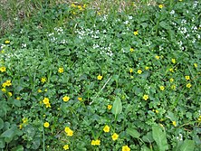
In the nature reserve there are habitat types (LRT) classified as valuable according to the Habitats Directive of the European Union such as species-rich borst grass lawns (LRT 6230), transitional and swinging bogs , mountain hay meadows (LRT 6520), montane spruce forests (LRT 9410) and birch bog forests (LRT 91D1). The Erzgebirgskreis mentions in the information sheet about the protected area the occurrence of typical and particularly protected plants:
- Bog pine (Pinus x rotundata grex arborea) ,
- Forest lice herb (Pedicularis sylvatica) ,
- Real arnica (Arnica montana) ,
- Round-leaved sundew (Drosera rotundifolia) and
- Fir devil's claw (Huperzia selago) . That too
- Spotted orchid (Dactylorhiza maculata) and
- Reddish peat moss (Sphagnum rubellum) occur.
The range of plants in the habitat type becomes nebulas
- Bulky bulrush (Juncus squarrosus) and
-
Erect cinquefoil (Potentilla erecta) exposed.
Used as bog plants - the narrow-leaved cottongrass (Eriophorum angustifolium) ,
- the vaginal cottongrass (Eriopherum vaginatum) and
- the bog bilberry (Vaccinium uligonosum) mentioned.
Broods of 22 bird species have been mapped. Other animal species have not yet been adequately studied. The red-backed shrike (Lanius collurio) occurs in the adjacent hedges and in open land.
The “flower-colored meadows” offer a habitat for butterflies. Mention is made of the round-eyed Mohrenfalter (Erebia medusa) and white-banded Mohrenfalter (Erebia ligea) and of the mother-of-pearl butterflies the imperial mantle (Argynnis paphia) and the great mother-of-pearl butterfly (Argynnis aglaja) .
Care and development
"Hydrological preservation and, if necessary, rehabilitation of the moor catchment area, nature conservation-appropriate maintenance of the moor and open land biotopes as well as species and biotope protection measures, especially for the moor pine", is how Friedemann Klenke describes the tasks to be carried out in the protected area. In the project profile of the Office for Ecology and Nature Conservation it is emphasized that the water balance of the protected area cannot be completely restored, but the improvement of the water balance through climatic and hydrological protection zones is essential. The rewetted peat extraction area will develop into bog and other damp forests, into which natural open areas are interspersed. Further sub-areas would have to be kept open through maintenance. It is also recommended that pipe grass covers be removed in some areas so that raw peat soils are created. It is suggested that the moor sprites , which are threatened with extinction in Saxony, should be preserved on the spot , multiplied and planted in suitable locations in the protected area, as well as forest maintenance. The previous maintenance and management is to be retained and optimized for intermediate bogs, arborist grass lawns and mountain meadows. In the montane spruce forests, further waterlogging and the associated improvement of the biotope structures are to be carried out and natural changes allowed.
Picture gallery
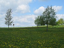
- The nature reserve "Moore south Schönheide" as a forest, moor and open landscape

Border area in the south

Remnants of the old fence
Flowering aspect in May

Hochmoorbächel

Source area on Fichzigweg
Northern limit of the reserve
.jpg)
.jpg)
.jpg)
.jpg)
.jpg)
.jpg)
literature
- RANA - Office for Ecology and Nature Conservation Frank Meyer: Special appreciation for nature conservation for the planned nature reserve "Moore south of Schönheide" , Hall 2012 digitized
- Erzgebirgskreis (Ed.): Flyer nature reserve Moore south of Schönheide , Annaberg (no year, after 2013, before 2017), digitized
- RANA project profile Nature conservation appraisal for the planned nature reserve “Moore south of Schönheide”, Halle 2011, digitized
- State Office for the Environment, Agriculture and Geology (Ed.): Summary Management Plan 286 "Mountain meadows around Schönheide and Stützengrün" digitized
See also
Web links
Individual evidence
- ↑ a b c d e f g h i j Erzgebirgskreis (ed.): Flyer nature reserve Moore south of Schönheide , Annaberg (no year, after 2013, before 2017), digitized version ( memento of the original from May 13, 2016 on the Internet Archive ) Info: The archive link was inserted automatically and has not yet been checked. Please check the original and archive link according to the instructions and then remove this notice.
- ↑ a b c d Friedemann Klenke: Protected areas in Saxony 2013 , in: Nature conservation work in Saxony, publisher Sächsisches Landesamt für Umwelt, Landwirtschaft und Geologie, 56th year 2014, Dresden 2015, p. 78, PDF downloadable
- ↑ a b c d Map of FFH areas and nature conservation areas from the map service of the Federal Agency for Nature Conservation . Maps cannot be clicked directly: click on the gear next to the search field, then click on FFH areas and enter mountain meadows around Schönheide and Stützengrün in the search field , accessed on August 24, 2018
- ↑ Situation map from the map service of the Federal Agency for Nature Conservation , accessed on August 24, 2018
- ↑ Natural space map service of the Landschaftsforschungszentrum eV Dresden ( information )
- ↑ RANA - Office for Ecology and Nature Conservation Frank Meyer: Conservation-related appreciation for the planned nature reserve "Moore south of Schönheide" , Halle 2012, p. 12 digitized ( memento of the original from March 6, 2016 in the Internet Archive ) Info: The archive link became automatic used and not yet tested. Please check the original and archive link according to the instructions and then remove this notice.
- ↑ Topographic map 1: 10.000 No. 5541-NW-Wilzschhaus of the state enterprise Geobasisinformation und Vermessung des Landes Sachsen, 2nd edition, Dresden 2012, ISBN 978-3-89679-546-5
- ↑ Saxony water balance portal (the map showing the water body cannot be called up directly, click on "Hochmoorbächel" with the water code 5411536 in the box on the left, then the detailed map will open)
- ↑ Sheet 196 from 1792 of the Berlin copy of the Saxon miles sheets ( digitized in the Dresden State and University Library )
- ↑ Sheet 195 of the Meilen Blätter von Sachsen - Berlin copy from 1791 ( link to the digitized version in the Dresden State and University Library )
- ↑ Topographic map 1: 25,000, edition with hiking trails, sheet 15 – Westerzgebirge– Eibenstock, Johanngeorgenstadt–, Sächsischer Staatsbetrieb Geobasisinformation und Vermessung, 2nd edition, Dresden 2010, ISBN 978-3-86170-717-2
- ↑ Nature reserves in the districts of Leipzig, Karl-Marx-Stadt and Dresden , Volume 5 of: Handbook of the nature reserves of the German Democratic Republic , Urania-Verlag, Leipzig, Jena, Berlin 1974, p. 101
- ↑ List of nature reserves in Saxony (C 19)
- ↑ Sachsen-Gesetze.de
- ↑ a b c Friedemann Klenke: Protected areas in Saxony 2013 , in: Nature conservation work in Saxony, Ed. Saxon State Office for Environment, Agriculture and Geology, 56th year 2014, Dresden 2015, p. 79, PDF downloadable
- ↑ RANA project profile Nature conservation appraisal for the planned nature reserve "Moore south of Schönheide", Halle 2011, digitized version


Alte Leite | Am Riedert | At Christening | Bärenbach | Bockautal | Conradswiese | Fichtelberg | Friedrichsheider Hochmoor | Great crane lake | Halbmeiler meadows | Hermannsdorfer Meadows | Hirschberg - Seiffener Grund | Cave pond | Hormersdorfer Hochmoor | Kleiner Kranichsee, Butterwegmoor and Henneberger Hang | Kuttenbach | Lohenbachtal | Moor at the Pfahlberg | Moor at the Red Puddle | Moors south of Schönheide | Moth houses heather | Rauenstein | Rauschenbachtal | Rungstock | Schieferbach | Schwarzwassertal | Black Heath - War Meadow | Steinbach | Front floodplain | Weather Fir Meadow | Zweach | Zwönitzer Moosheide