Morgensternhöhe
| Morgensternhöhe | ||
|---|---|---|
|
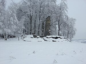
Morgenstenhöhe in winter |
||
| height | 711 m | |
| location | Saxony ( Germany ) | |
| Mountains | Ore Mountains | |
| Coordinates | 50 ° 38 '45 " N , 13 ° 14' 43" E | |
|
|
||
|
Summit cross |
||
The Morgensternhöhe is a hill between Zöblitz and Sprung in the Ore Mountains in Saxony . The 711 m high hill with meadows and forest is a station on the European long-distance hiking trail E3 . Its name goes back to the owner Christoph Morgenstern, first mentioned in a document in 1720.
view
From the path along the edge of the forest you can see parts of the Schwarzwassertal in the south, parts of Pobershau in the southwest, parts of the mountain town of Marienberg , its districts Lauta and Rittersberg in the west . In the northwest you can see Zöblitz, Niederlauterstein , Lauterbach , Wünschendorf and, if the visibility is good, the Augustusburg hunting lodge , to the north the Annahöhe between Zöblitz and Sorgau and to the northeast, Sprung, Hallbach , Sayda and the Schwartenberg near Neuhausen / Erzgeb. .
Tourist development
The Morgensternhöhe has been owned by the Erzgebirgsverein since 1911 . On the occasion of the 25th anniversary of the German emperor's throne, a stone was marked with the inscription " Wilhelm II. 1888-1913". In November 1933, a war memorial was erected for the victims of the First World War . Later a name plaque of the victims of the Second World War was put up there . The central commemoration of the Marienberg community for the 2019 Memorial Day took place at the war memorial on Morgensternhöhe. Around 120 people, including representatives of the city council and the city administration, the local Erzgebirgszweigverein (EZV), the Zöblitzer rifle club, the German armed forces and comrades from the volunteer fire brigade took part.
Directions
On the B 171 (coming from Zöblitz) at the entrance to the village, turn right towards Hüttstattmühle . After approx. 800 m there is parking, from which the Morgensternhöhe can be reached by a 15-minute walk.
Web links
- Morgensternhöhe , accessed on November 14, 2009
Individual evidence
- ↑ Memory of the war victims. In: Freie Presse from November 18, 2019.


