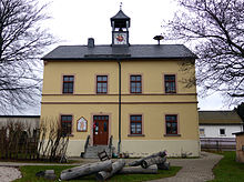
Lauta (Marienberg)
|
Lauta
Large district town of Marienberg
Coordinates: 50 ° 39 ′ 59 ″ N , 13 ° 8 ′ 46 ″ E
|
||
|---|---|---|
| Height : | 621 m | |
| Area : | 3.49 km² | |
| Residents : | 363 (Jan. 1, 2018) | |
| Population density : | 104 inhabitants / km² | |
| Incorporation : | January 1, 1994 | |
| Postal code : | 09496 | |
| Area code : | 03735 | |
|
Location of Lauta in Saxony |
||
Lauta is a district of the Saxon town of Marienberg in the Erzgebirge district .
geography
location
Lauta is about 2 kilometers northwest of Marienberg in the Ore Mountains . The 688 m above sea level is located southwest of Lauta . NN high Dreibrüderhöhe , southeast of the place the 655 m above sea level. NN high Lautaer Höhe.
Until the opening of the Marienberg bypass in 2007, the federal highway 174 Chemnitz - Reitzenhain crossed the town, since then it has passed Lauta north and east. There is also a connection to Lauterbach via Kreisstraße 8131.
Neighboring places
| Hilmersdorf | Lauterbach | |
| Gehringswalde |

|
|
| Marienberg |
history

The first written mention dates from 1434 as the Lute . In 1523, mining began in Lauta with the peasant mine at Bauer Morgengang . With the Reformation in 1539 the place belongs to the Parish Lauterbach, on October 1st, 1875 Lauta becomes part of the Parish Marienberg. In return, some colliery houses near Rittersberg and two former mountain buildings from Niederlauterstein with 27 inhabitants came to the Parish Lauterbach in 1897. In 1766 a school was built.
In 1818 August Schumann mentions Lauta in the State, Post and Newspaper Lexicon of Saxony concerning a. a .:
"The place has 230 inhabitants, a school, and is parish to Lauterbach."
In 1833 today's B 174 was laid through Lauta. A rare mineral found on the Rudolf-Schacht in 1881 was examined by the Freiberg mineralogist Friedrich August Frenzel , who named it Lautit - in 1899 the silver mining on this shaft came to an end. A horse peg that was in operation on the Rudolphschacht between 1838 and 1877 was faithfully rebuilt in the 1990s. In the associated visitor center there is an exhibition on the subject of "Mining in the Marienberger Revier". The mining landscape near Lauta is a selected site of the UNESCO World Heritage Ore Mountains Mining Region .
In 1883 the 18 m high "Priness-Marien-Turm" was built on the Dreibrüderhöhe .
In 1925 the place is connected to the electricity network. In order to supply the city of Chemnitz with water, the Rudolph shaft was opened for water pumping from 1929 to 1935, and the water was fed to the Neunzehnhain II dam.
On January 1, 1994 Lauta was incorporated into Marienberg.
Development of the population
|
|
|
Web links
- Lauta in the Digital Historical Directory of Saxony
Individual evidence
- ↑ Bergstadt Marienberg: Facts & Figures ( Memento of the original dated February 2, 2016 in the Internet Archive ) Info: The archive link was inserted automatically and has not yet been checked. Please check the original and archive link according to the instructions and then remove this notice. , accessed on March 29, 2018.
- ↑ a b cf. Lauta in the Digital Historical Directory of Saxony
- ^ The parish Marienberg. In: New Saxon Church Gallery, Ephorie Marienberg. Strauch Verlag, Leipzig 1908, column 14 ( digitized version ).
- ↑ cf. Lauta . In: August Schumann : Complete State, Post and Newspaper Lexicon of Saxony. 5th volume. Schumann, Zwickau 1818, p. 422.
- ^ Pferdegöpel in Lauta near Marienberg ( Memento from August 12, 2013 in the Internet Archive )
- ↑ Information about the Rudolphschacht on the Ore Mountains Mining Region ( Memento from July 11, 2012 in the web archive archive.today )
- ^ Area changes from January 1, 1994 to December 31, 1994 on the website of the State Statistical Office of the Free State of Saxony , p. 11 (PDF file; 63 kB), accessed on November 25, 2010.
- ↑ Districts of the city of Marienberg on marienberg.de , accessed on January 21, 2012


