Municipio Tarija
| Municipio Tarija | ||
|---|---|---|
 Tajzara dunes |
||
| Basic data
|
||
| Population (state) - population density |
205,346 inhabitants (2012 census) 100 inhabitants / km² |
|
| Post Code | 06-0101 | |
| Telephone code | (+591) | |
| surface | 2,047 km² | |
| Coordinates | 21 ° 33 ′ S , 64 ° 32 ′ W | |
|
|
||
| politics
|
||
| Department | Tarija | |
| province | Province of Cercado | |
| Central place | Tarija | |
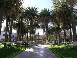
 Plaza in Tarija |
||
| climate | ||
 Climate diagram Tarija |
||
The Municipio Tarija is a district in the Tarija Department in the South American Andean state of Bolivia .
Location in the vicinity
The municipality Tarija is the only municipality in the province of Cercado . It borders the province of Eustaquio Méndez in the northwest, the province of José María Avilés in the southwest , the province of Aniceto Arce in the south , and the province of Burnet O'Connor in the east .
geography
Tarija is conveniently located between the country's different climate zones, on the edge of the Andes at around 1,900 m above sea level. NN., So that mostly mild and pleasant weather prevails. In the rainy season between December and February (summer months) there are frequent torrential thunderstorms. The rest of the year has very little rainfall (see Tarija climate diagram).
The landscape has been eroded by the centuries of clearing and the city is framed by a bare mountain range. The area around Tarija used to be Bolivia's grain chamber. Today the region is particularly rich in natural gas .
population
The population of the Municipio Tarija has almost doubled in the past two decades:
- 1992 : 108,241 inhabitants ( census )
- 2001 : 153,457 inhabitants (census)
- 2012 : 205,346 inhabitants (census)
The population density of the municipality is 100 inhabitants / km², the proportion of the urban population is 87.4 percent ( 2012 ).
The life expectancy of newborns in 2001 was 70.1 years.
The literacy rate among those over 19 is 89 percent, 95 percent for men and 83 percent for women ( 2001 ).
politics
Results of the elections for the municipal council ( concejales del municipio ) in the regional elections on April 4, 2010:
| electoral legitimate |
electoral participation |
valid votes | UNIR | MAS-IPSP | BI-CO | CC | CD RENACER | VAMOS | PDC | ||
|---|---|---|---|---|---|---|---|---|---|---|---|
| 123.726 | 106.403 | 89,711 | 43,402 | 23,230 | 10,615 | 9,027 | 1,657 | 1,013 | 767 | ||
| 86.0% | 84.3% | 48.4% | 25.9% | 11.8% | 10.1% | 1.8% | 1.1% | 0.9% |
Districts
The municipality has an area of 2,047 km² and is divided into the following cantons :
- 06-0101-01 Canton Tarija - 7 localities - 182,323 inhabitants
- 06-0101-02 Canton Santa Ana - 9 localities - 2,111 inhabitants
- 06-0101-03 Canton of Tolomosa - 16 towns - 4,342 inhabitants
- 06-0101-04 Yesera canton - 9 localities - 1,594 inhabitants
- 06-0101-05 Canton Lazareto - 32 villages - 7,410 inhabitants
- 06-0101-06 Canton of San Mateo - 18 towns - 4,876 inhabitants
- 06-0101-07 Canton Alto España - 3 towns - 338 inhabitants
- 06-0101-08 Junacas Canton - 7 towns - 622 inhabitants
- 06-0101-09 Canton of San Agustín - 14 localities - 1,724 inhabitants
- 06-0101-11 Canton Compuerta - 1 village - 6 inhabitants
Localities in the municipality of Tarija
- Santa Ana Canton
- La Pintada Pop. 646 - Santa Ana La Vieja Pop. 477.
- Tolomosa Canton
- Tolomosa Grande 936 inhabitants.
- Yesera Canton
- Yesera Norte 442 pop - Yesera Centro 363 pop
- Canton of Lazareto
- San Andrés 1593 pop - Guerra Huayco 1496 pop - Turumayo 1253 pop - Lazareto 795 pop.
- Canton of San Mateo
- San Mateo 1735 pop - Monte Sud 638 pop - Monte Centro 308 pop
- Canton of Alto España
- España Sur 174 pop.
- Junacas Canton
- Junacas Sur 107 pop - Junacas Norte 66 pop.
- Canton of San Agustin
- San Agustín Sur pop. 181
Individual evidence
- ^ Instituto Nacional de Estadística Bolivia (INE) 1992
- ↑ Instituto Nacional de Estadística Bolivia (INE) 2001
- ↑ Instituto Nacional de Estadística (INE) 2012 ( Memento of the original of July 22, 2011 in the Internet Archive ) Info: The archive link has been inserted automatically and has not yet been checked. Please check the original and archive link according to the instructions and then remove this notice.
- ↑ Acta de computo Nacional Electoral Departamentales, Municipales y Regional 2010
Web links
- Municipio Tarija - General Maps No. 60101
- Municipio Tarija - detailed map and population data (PDF; 629 kB) ( Spanish )
- Departamento Tarija - social data of the municipalities (PDF; 3.05 MB) ( Spanish )
