Mwanza (region)
| Mwanza | |
|---|---|
| Basic data | |
| Country | Tanzania |
| Capital | Mwanza |
| surface | 25,233 km² |
| Residents | 2,772,509 (2012) |
| density | 110 inhabitants per km² |
| ISO 3166-2 | TZ-18 |
Coordinates: 3 ° 0 ′ S , 33 ° 0 ′ E
Mwanza is a region in Tanzania on the southern shore of Lake Victoria . The capital is also called Mwanza . The region is bordered by the Mara region to the northeast, the Simiyu region to the east, the Shinyanga region to the south, the Geita region to the west, and the Kagera region to the northwest .
geography
The region has a size of 25,233 square kilometers, of which 13,437 are water areas and 11,796 square kilometers are land areas. At the 2012 census, the region had around 2.8 million inhabitants. In addition to the area on the south bank of Lake Victoria, the land area also includes many islands in Lake Victoria, the largest being Ukerewe , Ukora, Kome and Maisome . The climate in Mwanza is tropical, Aw according to the effective climate classification . Short rain showers fall in the region from October to December and longer rains from March to May. The precipitation usually falls irregularly, often only in small areas. The months of June, July and August are particularly dry. The total annual precipitation is between 750 millimeters in the south and 1200 millimeters on the island of Ukerewe.
history
Before the German colonial era, the area belonged to the Sukuma , Kerewe, Kara and Zinza peoples. In 1963 the area received official regional status.
Administrative division
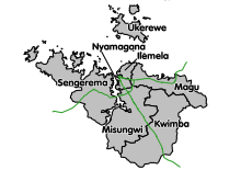
The Mwanza region is divided into the following seven districts:
| District | Capital | Area km² |
Population 2012 |
|---|---|---|---|
| Ilemela | Ilemela | 895 | 343.001 |
| Kwimba | Ngudu | 3,599 | 406.509 |
| Magu | Magu Mjini | 3,070 | 299,759 |
| Misungwi | Misungwi | 1,947 | 351,607 |
| Nyamagana | Mwanza | 425 | 363,452 |
| Sengerema | Sengerema | 3,335 | 663.034 |
| Ukerewe | Nansio | 640 | 345.147 |
| Mwanza (region) | Mwanza | 19,791 | 2,772,509 |
economy
Around 85 percent of the working population work in agriculture. Cotton, which has been grown for export since the late 19th century , has lost its importance since the 1980s. It has been replaced by fishing as the largest foreign exchange earner in the region.
Nature reserves, sights
- Rubondo National Park : This 456 square kilometer national park also includes Maisome Island on Lake Victoria. The park is known for its water birds, but the rare sitatunga as well as elephants, giraffes, hippos, bushbucks, pythons and crocodiles are also at home here.
- Saa Nane National Park : The park is 2.18 square kilometers and was declared a national park in 2013. It is located on three islands in Lake Victoria, only two kilometers southwest of the capital Mwanza. In addition to impalas, wild cats, crocodiles and pythons, green monkeys also live here, which cannot be found anywhere else in Tanzania.
Web links
Individual evidence
- ↑ a b Mwanza Region, Regional Secretariat Strategic Plan 2014-2017. (PDF) December 2013, pp. 8–9 , accessed on January 29, 2020 .
- ^ National Bureau of Statistics & Office of Chief Government Statistician: Basic Demographic and Socio-Economic Profile, Statistical Tables, Tanzania Mainland . Dar es Salaam, Zanzibar 2014, on www.tanzania.go.tz, PDF document p. 15 (English)
- ↑ Google Maps. Retrieved January 29, 2020 (de-US).
- ↑ Climate Mwanza: Temperature, climate graph, Climate table for Mwanza - Climate-Data.org. Retrieved January 29, 2020 .
- ^ National Bureau of Statistics: 2012 Population and Housing Census. (pdf) March 2013, accessed on September 7, 2019 (English).
- ↑ Overview of the Regional Economy. Mwanza region. Tanzania National Website, 2004 ( Memento from May 25, 2008 in the Internet Archive )
- ↑ Tanzania in Figures 2018. (PDF) National Bureau of Statistics, June 2019, p. 8 , accessed on January 29, 2020 .
- ^ Rubondo Island National Park - Tanzania Tourism. Retrieved January 29, 2020 .
- ↑ Saanane Iceland National Park - Tanzania Tourism. Retrieved January 29, 2020 .


