
Niokolo-Koba National Park
| Niokolo-Koba National Park | |
|---|---|
|
UNESCO world heritage |
|

|
|
| The Gambia River in Niokolo-Koba National Park |
|
| National territory: |
|
| Type: | nature |
| Criteria : | (x) |
| Surface: | 913,000 ha |
| Reference No .: | 153 |
| UNESCO region : | Africa |
| History of enrollment | |
| Enrollment: | 1981 ( session 5 ) |
| Red list : | since 2007 |

The Niokolo-Koba National Park ( French Parc national du Niokolo-Koba , PNNK ) is located in southeastern Senegal on the border with Guinea at an altitude of 15 to 300 m above sea level . The park is 9,130 square kilometers and since 1981 as a UNESCO - World Heritage recognized. Because of a planned dam and the prevailing poaching, it was added to the Red List of World Heritage in Danger in 2007. It is named after the Gambia tributary Niokolo Koba .
Geographical location
The national park extends over three regions. The southeast part to the rivers Gambia in the west and south and Niokolo Koba in the north is in the Kédougou region . The large part north and west of the two rivers belongs to the Tambacounda region , but in the west only up to the lower reaches of the Koulountou , which flows into the Gambia from the south. To the west of the Koulountou, in the Kolda region , an approximately 15 kilometer deep strip complements the national park, the western border of which is the road that leads from Tambacounda via Médina Gounass to Koundara in Guinea-Conakry and thus to the most important border crossing into this neighboring country.
vegetation
The vegetation consists mainly of Guinea and Sudan savannah, towards the east the vegetation becomes increasingly drier. There are extensive gallery forests on the river banks . The highest point is the Mont Assirik . During the only rainy season from June to October, 1000 to 1100 mm of rain fall. In addition to seasonally flooded grass savannahs and swamps, there are also drier forests and bamboo in the gallery forest. More than 1500 plant species have been counted in the park.
fauna

Niokolo Koba was known for its abundant wildlife and is still the last, albeit unsafe, home for some West African species. The number of large mammals decreased from about 45,000 to less than 1,000 between 1990 and 2007, a loss of 98%. There are 84 species of mammals, 330 species of birds, around 60 species of reptiles and amphibians, and 60 species of fish in the park.
Most important is the last remaining wild population of the western giant eland ( Taurotragus derbianus ), current population less than 200. The West African lion and the African wild dog are threatened with extinction , the situation for the leopard is uncertain. In the gallery forests around the wooded slopes of Assirik plateaus for about 150 life West African chimpanzees ( Pan troglodytes verus ). Other species of monkey are the Guinea baboon , the western green monkey as well as the hussar monkey and Temminck colobus monkey . All ungulates suffered dramatic populations, the roan antelope from more than 6,000 in 1990 to currently around 700, the West African hartebeest from 5,000 to 150, the Kob antelope from 24,000 to currently around 100, the Defassa waterbuck from over 3,000 to 10 and the African buffalo from 8000 to less than 500. The westernmost population of the West African giraffe ( Giraffa camelopardalis peralta ) and the elephant have died out. In 2006, 10 released elephants lived in Niokolo Koba after the original population fell victim to poaching. The situation is unknown for Sitatunga , hippos , warthogs and bush pigs, smaller antelopes and all three African crocodile species.
It is uncertain to what extent national and international protective measures will be successful. The problems of unchecked poaching with heavy weapons, bushmeat hunting and bird trapping have not been resolved under the given circumstances.
traffic
The north-east of the national park is accessed by the national road N 7 , which crosses this part on the way from Tambacounda in the north-west to Kédougou in the south-east and spans the dry valley of the central Niokolo Koba with a 70-meter-long bridge.
Two kilometers south of this bridge is the Niokolo-Koba airfield , one of the smallest unpaved airfields in Senegal. In the west of the park, near Simenti on the north bank of the Gambia, is the Simenti airfield
photos
Slope in the national park
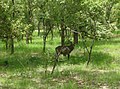
Waterbuck

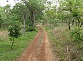
River course


Individual evidence
- ↑ United Nations World Conservation Monitoring Center: IUCN State of Conservation Report Niokolo Koba National Park 2008 , last update 2011
literature
- Wally and Horst Hagen: The African national parks as habitats for elephants . In: Vitus B. Dröscher (1990): Save the Elephants of Africa (p. 220)
Web links
- Entry on the UNESCO World Heritage Center website ( English and French ).
- Data sheet of the UNEP-WCMC ( Memento from December 3, 2007 in the web archive archive.today )
- Page with photos of the most striking wildlife
- Kassoumay: Parc du Niokolo Koba ( Memento from May 12, 2017 in the Internet Archive )
- Parc National du Niokolo-Koba at Geonames

Heritage: Gorée Island (1978) | Isle of Saint Louis (2000) | Senegambian Stone Circles (2006) | Saloum Delta (2011) | Bassari Land: Cultural Landscapes of the Bassari, Fula and Bedik (2012)
Natural heritage: Djoudj National Bird Sanctuary (1981) | Niokolo-Koba National Park (1981)
Coordinates: 13 ° 4 ′ 0 ″ N , 12 ° 43 ′ 0 ″ W.