Scherfbachtal nature reserve (Odenthal)
|
Scherfbachtal nature reserve (Odenthal)
|
||
|
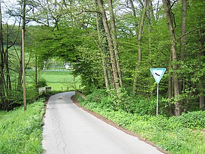
The Scherfbachtal in Niederscherf |
||
| location | Odenthal , North Rhine-Westphalia , Germany | |
| surface | 105.30 | |
| Identifier | GL-029 | |
| WDPA ID | 165381 | |
| Geographical location | 51 ° 2 ' N , 7 ° 10' E | |
|
|
||
| Setup date | 1994 | |
| Framework plan | Landscape plan Middle Dhünn | |
| administration | Lower landscape authority Rheinisch-Bergischer Kreis | |
The nature reserve Scherfbachtal (Odenthal) is located in the municipality of Odenthal in the Rheinisch-Bergisch district . It extends in five individual sections between Odenthal and Klev .
description
Part of the Scherfbachtal source stream system northeast of Klev
The area in the Scherfbach Oberlauf extends mainly along the forest-open land border near Klev with several inflows. In the north it runs partly through grassland and in the north-eastern lower reaches through the forest in a wider sole valley. In the latter case, an alder forest has been developed in the floodplain . The grassland in the floodplain and on the lower slopes consists partly of intensive hay meadows, partly also of flowery meadows that have fallen fallow in places. The forest stands on the lower slopes are also formed by species-poor high beech forests . The flowing water system of the Scherfbach, located northeast of Klev, has a natural course and is representative of the Bergisches Land.
Part of Scherfbachtal southeast of Klev
The area includes the tributaries to the Scherfbach and the floodplain that accompanies the stream, partly with wet grassland southeast of Klev. Some species-poor beech forest stands on the lower slope are included. The flowing water system of the Scherfbach, located southeast of Klev, is representative of the Bergisches Land due to its natural course. The special value is based on the comparatively large extent, the relatively low human impairment of the water quality due to the predominantly remote settlement of the source regions and the often near-natural tillering of the slopes. The area is part of the river network system of the Bergisches Land and an important catchment area for the Scherfbach, which drains to the west.
Part of the Upper Scherfbachtal
In the upper section of the valley between Klev and Klasmühle , only the meandering stream with a closed fringe of old alders, ash trees and tree willows and a narrow fringe of more or less damp pastures are included in the nature reserve. Between Klasmühle and Höffe, the near-natural brook is around 2 m wide, clear, sometimes fast-flowing to slowly meandering. To the south of Klasmühle there are wet pastures , some of which have fallen fallow. Sedge and meadowsweet companies can be found here . At Amtmannscherf there is an old oak-hornbeam or alder-rich alluvial forest with a high proportion of oak and a dense and demanding layer of shrubs and herbs.
Part of Höffer Siefen
The Kerbtal section of the Kirsbach, which flows into the Scherfbach at Höffe, is cut into Grauwacke as a loess-loam-shaped lowland brook . The lower reaches of the two source streams with their challenging source stream fauna flow gently meandering over a short stretch between the wooded edge of the valley and pastures to the junction east of Unterkirsbach . At the south end there are younger fruit trees and a group of riparian trees. The northern and eastern borders are formed by well-developed oak-hornbeam forest remains with a species-rich herb layer. They are rich in ferns , mosses , earth lichens and mushrooms on very steep valley slopes.
Part of the Lower Scherfbachtal
The last part of the nature reserve is the section of the Scherfbach up to the confluence with the Dhuenn northwest of Funkenhof . In this section you will find well-developed oak-hornbeam floodplain forests with varied small reliefs, numerous seepage springs with typical and floristically remarkable spring flora and small-scale alder forest . On the valley slope north of Voiswinkel and east of Küchenberg there are also richly developed beech forests . All forests are very species-rich with a dense, demanding layer of shrubs and herbs. The brook is 2 to 4 m wide, relatively little polluted and has a rich brook fauna. It meanders strongly and has partial clay walls, greywacke gravel, mud banks, etc. in places. In places there are small wet meadows. The isolated floodplain section near the mouth was reforested with oak, hornbeam and ash as thickets.
natural reserve
The protection designation has been made around the species-rich wetlands, wet and wet meadows of the valley floodplains as well as poor pastures on the valley slopes, the open grassland areas with wooded fringes, alluvial forest remains and structurally rich riparian woodlands, the near-natural water course of the Scherfbach with pools , gravel and gravel banks, as well as numerous narrow Siefentäler secure, maintain and develop with pronounced spring origins and spring corridors.
See also
Individual evidence
- ↑ a b c d e f g nature reserve "Scherfbachtal (Odenthal)" in the specialist information system of the State Office for Nature, Environment and Consumer Protection of North Rhine-Westphalia , accessed on May 16, 2017.


