New Vienna
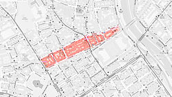
The district New Vienna in the 9th Viennese district of Alsergrund was created as a "small urban expansion". 1853
history
Until 1853, Berggasse (then: An der Berg-Strasse ) on Alsergrund formed the boundary of the Glacis . Only the northern street front with the odd house numbers was built. At the beginning of the 1850s, the War Ministry needed a lot of money to build the arsenal and the Franz-Josefs-Kaserne . In September 1853, the Imperial and Royal General-Genie-Direktion des Heeres moved the border of the Glacis by almost 100 meters to the south, up to today's Türkenstrasse. The space thus gained between Berggasse and Türkenstrasse was parceled out and auctioned. The area was called New Vienna . The new building area had a size of 60,000 m² and was divided into six building blocks.
Building
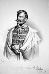
The construction initially extended from Währinger Strasse to today's Schlickgasse. The first settler was the cavalry general Franz Schlik zu Bassano and Weißkirchen , who had his Palais Schlick built at Türkenstrasse 25 from 1856–1858 according to plans by the architect Carl Tietz . From 1270 to 1788 the Rabenstein , the "Viennese High Court", stood here. The place of execution consisted of a round brick terrace on which the convicts were judged. After General Schlik's death in 1862, Schlickgasse was named after him that same year , and Schlickplatz ten years later .
The New Vienna facility was a dress rehearsal for Vienna's urban expansion , which began a little later. Interior Minister Alexander von Bach therefore closely observed the events in New Vienna. Experience could be gained here on how fallow land can be converted into lucrative building land and, above all, what prices could realistically be achieved.
building
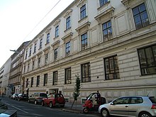
Berggasse 16: Palais Festetics
The palace was built in 1858 in the style of the New Vienna Renaissance by the architectural duo Johann Julius Romano (1818–1882) and August Schwendenwein (1817–1885) for Eugénie Countess Festetics von Tolna (1826–1894).
Türkenstrasse 25 / Schlickgasse 1: Palais Schlick
City palace built by architect Carl Tietz and city architect Anton Grünn in the style of early historicism. The five-storey corner house has a special architectural feature with the round corner tower.
Berggasse 34 / Türkenstrasse 35 / Hahngasse 2 / Oskar-Morgenstern-Platz 1: University of Vienna Rossau
Since 1404 there has been a "Tandelmarkt" in Vienna for the trade in used clothing and various everyday objects. Its location has shifted over the centuries. On April 17, 1863, the Vienna City Council decided to close the Tandelmarkt (today's area: Schwarzenbergplatz - Konzerthaus ) located between the Wienfluss and Am Heumarkt and relocate it to the Rossauer Glacis . Of the 330 second-hand dealers based on the Vienna River, only 200 (with financial support from the municipality) were willing to purchase a piece of land in the southern part of New Vienna, between the Rossauer barracks and the Rossauer Lände police station . The architect Emil Förster (1838–1909) erected a single-storey hall building with a round arch in the style of an oriental bazaar for (continuously windowless) 200 shops ( vaults ). In order to prevent damage from the nearby Danube Canal , which often leads to floods , the building site was raised by around 2.5 meters; the closest access to the Danube Canal was via a staircase in the area of the former kk Mauthhaus ( kk water customs office , colloquial : Lampelmauth ). The market area was accessed through eight aisles on the narrow and thirteen on the long side. The allocation of the vaults took place in a lottery drawn by an orphan . The market started operating (at least partially) on Michaelmas Day in 1864 (September 29).
The market hall was badly damaged by bombs in 1944 and was finally demolished.
The architect Franz Schuster built a high-rise office building on this site in 1955, which originally served as pension insurance for the workers. The architecture critic Friedrich Achleitner said: "Overall, the building reflects the self-assured helplessness of the functionalism of the fifties in relation to the historic city". From 2011 to 2013 the building was renovated and rebuilt. It now serves as the University of Vienna Rossau with the address Oskar-Morgenstern-Platz 1 (OMP1) of the University of Vienna and houses the faculties of mathematics and economics . 2500 students and 800 university employees are accommodated on 30,000 m² of usable space, the large lecture hall has 400 seats.
The space between the building and the Rossauer Bridge was named Oskar-Morgenstern-Platz in 2012 by the City of Vienna, after the economist Oskar Morgenstern (1902–1977), one of the founders of game theory .
literature
- Kurt Mollik, Hermann Reining, Rudolf Wurzer: Planning and implementation of the Vienna Ringstrasse zone . Franz Steiner Verlag, Wiesbaden, 1980. ISBN 3-515-02481-6 . (Volume III by Renate Wagner-Rieger (ed.): The Vienna Ringstrasse. Picture of an Era. (Volume I - XI) . Franz Steiner Verlag, Wiesbaden, 1972–1981. ISBN 978-3-515-02482-2 )
Individual evidence
- ↑ Vienna Local Newspaper. (...) Municipal council meeting on April 17th. In: Das Vaterland , No. 89/1863 (fourth year), April 19, 1863, p. 3 (unpaginated), column 2 middle. (Online at ANNO ). .
- ↑ We learn the following about the construction of the new Tandelmarkthalle: In: Fremd -Blatt , No. 119/1864 (18th year), April 30, 1864, p. 4 (unpaginated), column 1 f. (Online at ANNO ). .
- ↑ Tandelmarkt at www.wien.gv.at, accessed on March 7, 2015.
- ^ Friedrich Achleitner: Austrian architecture in the 20th century. Volume III / 1. Residenz Verlag, St. Pölten, Salzburg 2010, ISBN 978-3-7017-3208-1 , p. 237.
- ↑ Oskar-Morgenstern-Platz 1 on rossau.univie.ac.at, accessed on March 5, 2015.
Remarks
- ↑ As is clear from reports of local newspapers stating those years, the western border was the planning area New Vienna on the other side of the Währingerstraße (then Währinger Alley ) passed the Red House (now the intersection Garnisongasse-Schwarzspanierstrasse). The Rotes Haus –Währinger Strasse area (16 parcels) was reserved for state purposes, including the construction of the university. The nearest votive church, which was under construction from 1856, was sometimes considered the center of New Vienna . - See: Submitted. In: Die Presse , Morgenblatt, No. 58/1857 (Xth volume), March 12, 1857, p. 3 (unpaginated), column 3. (Online at ANNO ). and Felix Czeike : Rotes Haus in the Vienna History Wiki of the City of Vienna , accessed on December 22, 2017.
Coordinates: 48 ° 13 ' N , 16 ° 22' E


