Neudorf (Grafenau)
|
Neudorf
City of Grafenau (Lower Bavaria)
Coordinates: 48 ° 50 ′ 57 ″ N , 13 ° 25 ′ 59 ″ E
|
|
|---|---|
| Height : | 711 m above sea level NN |
| Residents : | 892 (8 Aug 2014) |
| Incorporation : | 1st January 1974 |
| Postal code : | 94481 |
| Area code : | 08552 |
|
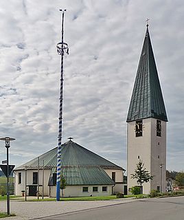
The branch church Herz Jesu
|
|
Neudorf is a district of the city of Grafenau in the Lower Bavarian district of Freyung-Grafenau . Until 1974 it formed an independent municipality.
location
The Angerdorf Neudorf is located in the Bavarian Forest about three kilometers east of Grafenau on the federal highway 533 , which is also known there as Glasstraße .
history
Even in the oldest Salbuch the Counts of neck is Newndorf mentioned in 1395 with 16 fiefs first documented. It later formed a chairman and was subordinate to the Inner Office in the Aigen of the Bärnstein court .
The Bavarian original cadastre shows 18 farms and their associated clods in Neudorf around 1808 .
In 1811/12 there lived 123 people in 25 houses with 23 barns, all of which were covered with clapboards. In 1818 the somewhat smaller municipality of Neudorf was formed from the Neudorf tax district . Three properties burned down in 1846 and six in 1848. The reconstruction changed the village considerably, because the traditional farmhouses with swallow nests (sloping roofs on the gable ends), belt ceilings and barrel vaults disappeared, and massive houses were built that were connected to a street wall by double gates. In 1864, Bishop Heinrich von Hofstätter consecrated the altar stone of the small village chapel, which was enlarged into a school chapel in 1903. In 1903, 402 people lived in 68 households in the entire municipality of Neudorf with the districts of Lichteneck, Elmberg, Kleblmühle and Neudorf. In 1931 some of the farms again fell victim to the fire.
Only the former Waldlerhaus , which is a listed building, has been preserved in terms of the historical structure .
In the course of the land consolidation measures that were carried out from 1959 to 1971, a model land consolidation for the entire Bavarian Forest was created in Neudorf . The municipality of Neudorf was incorporated into the city of Grafenau on January 1, 1974 as part of the regional reform . On May 25, 1987 Neudorf had 121 apartments in 91 buildings with living space and 353 residents. The former farm is now largely built up. The former school has been used by the Grafenau Technology Campus since 2013.
Attractions
Branch church Herz Jesu. The former school chapel was replaced by a modern oval church building in 1964. The consecration took place on June 17, 1966. Wolf Hirtreiter designed the back wall of the altar in the form of a ceramic depiction of the Sacred Heart.
education and parenting
- Technology Campus Grafenau
- Caritaskindergarten Neudorf St. Martin
societies
- Neudorf volunteer fire brigade
- Rifle club Steinbügl Neudorf
- Sports club Neudorf e. V.
literature
- Ulrich Pietrusky, Donatus Moosauer: The Bavarian Forest - rediscovered in flight , Morsak Grafenau Verlag, 1985, ISBN 3-87553-228-7
- Hermann Neumann: History of the Grafenauer Land . In: The Freyung-Grafenau district , 1982
- Franziska Jungmann-Stadler: Grafenau: The dishes Bärnstein, Dießenstein and neck . Historical Atlas of Bavaria I / XLV, Munich 1992, ISBN 3 7696 9910 6
Web links
- Neudorf in the location database of the Bavarian State Library Online . Bavarian State Library
Individual evidence
- ^ Neudorf on a historical map
- ↑ LfD list for Grafenau, page 6 (.pdf)
- ↑ Bavarian State Office for Statistics and Data Processing (Ed.): Official local directory for Bavaria, territorial status: May 25, 1987 . Issue 450 of the articles on Bavaria's statistics. Munich November 1991, DNB 94240937X , p. 177 ( digitized version ).

