Notre-Dame-du-Rocher
| Notre-Dame-du-Rocher | ||
|---|---|---|
|
|
||
| local community | Athis-Val de Rouvre | |
| region | Normandy | |
| Department | Orne | |
| Arrondissement | Argentan | |
| Coordinates | 48 ° 48 ′ N , 0 ° 24 ′ W | |
| Post Code | 61100 | |
| Former INSEE code | 61313 | |
| Incorporation | January 1, 2016 | |
| status | Commune déléguée | |
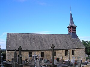
 Church of Our Lady |
||
Notre-Dame-du-Rocher is a village and a former French commune with 53 inhabitants (as of January 1, 2017) in the Orne department in the Normandy region . It belonged to the canton of Athis-de-l'Orne and the Arrondissement of Argentan .
With effect from January 1, 2016, the previous communes of Athis-de-l'Orne , Bréel , La Carneille , Notre-Dame-du-Rocher , Ronfeugerai , Ségrie-Fontaine , Taillebois and Les Tourailles became a nouvelle commune with the name Athis -Val de Rouvre and have the status of a Commune déléguée in the new municipality . The administrative headquarters are in Athis-de-l'Orne.
geography
Notre-Dame-du-Rocher is in close proximity to the D15 road, which runs west to Condé-sur-Noireau and east via Putanges-Pont-Écrepin to Argentan . The Rouvre flows along the western and northern edge of the former municipality ; on the border with Taillebois , the Lembron , which comes from there, flows into the Rouvre. Like large parts of the region, it is shaped by the Bocage landscape and primarily comprises pastures and agricultural fields. The soil contains large amounts of granite , some of which come to the surface in the form of small stones and rocks.
Until 2016, the municipality bordered Ségrie-Fontaine in the north, Bréel in the northeast, Sainte-Honorine-la-Guillaume in the southeast, La Carneille in the southwest and Taillebois in the west.
history
Originally the village was called Mille Savattes and emerged as an independent municipality under this name during the French Revolution . From 1801 it was called Mille-Savates after an adaptation of the spelling , before it was given the current name Notre-Dame-du-Rocher in 1878 . The village church of the same name served as a model for the Notre-Dame part , while Rocher means rock and is probably due to the corresponding landscape character. Based on this, the inhabitants are called Rupestriens , derived from the Latin word rupes (rock) .
At the time of the Hundred Years War , the present-day community belonged to the areas occupied by England in the 15th century and was subject to the special protection of the English King Henry IV. The area was traditionally agricultural and has retained this character to this day. A system located on the Rouvre serves to supply the region with water.
Population development
| year | 1962 | 1968 | 1975 | 1982 | 1990 | 1999 | 2011 |
| Residents | 95 | 89 | 72 | 72 | 73 | 66 | 64 |
During the French Revolution, the population was 220 in 1793 and increased to 322 in 1831. It then sank slightly until it collapsed significantly at the end of the 19th century and fell to 152 people by 1901. This trend continued, so that in 1962, with 95, fewer than 100 inhabitants were registered for the first time.
Web links
Individual evidence
- ↑ Decree NOR 1200-15-0421 prefecture on the formation of the commune nouvelle Athis-Val de Rouvre of 16 December 2015 .
- ↑ Mairie de Notre-Dame-du-Rocher , annuaire-mairie.fr
- ↑ a b Notre-Dame-du-Rocher ( Memento of May 20, 2009 in the Internet Archive ), athis-bocage.com
- ↑ a b Notre-Dame-du-Rocher , cassini.ehess.fr
