Nova Scotia Highway 103
| Highway 103 in Nova Scotia, Canada | |
| Fishermen's Memorial Highway | |

|
|
| map | |
| Basic data | |
| Operator: | Nova Scotia Department of Transportation and Infrastructure Renewal |
| Start of the street: |
Halifax ( 44 ° 39 ′ N , 63 ° 39 ′ W ) |
| End of street: |
Yarmouth ( 43 ° 51 ′ N , 66 ° 5 ′ W ) |
| Overall length: | 294 km |
|
County : |
|
|
Course of the road
|
|
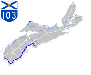
The Nova Scotia Highway 103 (NS 103) is located in the Canadian province of Nova Scotia , it has a length of 294 km. The highway begins south of Halifax and ends in Yarmouth . As a feeder route, the route is part of the National Highway System . In memory of Nova Scotia fishermen who perished while working at sea, the highway was named the Fishermen's Memorial Highway in 2013.
course
The highway begins on Highway 102 in the southwest of Halifax, it runs from there in a northwest direction to St. Margarets Bay . The route runs essentially parallel to the east coast of Nova Scotia and develops it. It serves as a bypass road around the localities; Highway 103 replaces its predecessor, Highway 3 , in large parts . With its remaining sections, this leads the towns directly or even closer to the coast. From St. Margarets Bay it goes along the coast in a southwest direction. In Mahone Bay Highway 3 branches off to Lunenburg from which to UNESCO - World Heritage belongs. At Barrington , Highway 103 changes direction to the northwest and ends in Yarmouth .
Web links
Individual evidence
- ↑ Canada's National Highway System - Annual Report 2017. Council of Ministers Responsible for Transportation and Highway Safety, accessed April 24, 2019 .
- ↑ Suzette Belliveau: Nova Scotia's Highway 103 renamed Fishermen's Memorial Highway. In: CTV News Atlantic . CTV Atlantic, June 12, 2013, accessed April 24, 2019 .
