Oberhau
|
Oberhau
City of Koenigswinter
Coordinates: 50 ° 41 ′ 16 ″ N , 7 ° 20 ′ 14 ″ E
|
||
|---|---|---|
| Incorporation : | 1st August 1969 | |
| Postal code : | 53639 | |
| Area code : | 02244 | |
|
Location of Oberhau in North Rhine-Westphalia |
||
|
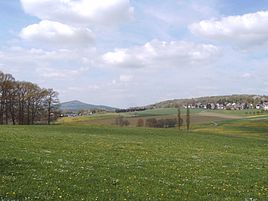
View of Eudenbach and Rostingen - on the left in the background the Mount of Olives
|
||
The Oberhau is a district belonging to the city of Königswinter , to which 13 places belong. The village of Willmeroth is also part of the historic Oberhau region .
geography
The Oberhau belongs to the mountain region of Königswinter am Rhein in the Rhein-Sieg district . The mountain region is the side of the Siebengebirge that is turned away from the Rhine ; naturally , it lies in the northwest of the Asbach plateau in the foothills of the Niederwesterwald . The closest larger town outside of the district is Oberpleis . The town of Eudenbach , which also houses the local elementary school and the multi-purpose hall, is centrally located. In the eastern part are located at or on the Musser Heath (also Musser Heide ) the nature reserves Komper Heide and Segelfluggelände Eudenbach with the Palatinate Rhineland-on page to the old limit point Lökestein adjoining nature reserve Buchholz Moor with Lökestein and sour Wieser Heide , in the north-west the Hühnerberg basalt quarry nature reserve .
history
The name is probably derived from the term "Oberer Hau" ( Hau = blow). According to one theory, the name in the 13th century by priests and officials of the provost Oberpleis introduced that hit wood there.
The Oberhau belonged as Honschaft the parish Oberpleis in Bergisch Office Blankenberg . The Duchy of Berg was founded in connection with the formation of the Rhine Confederation in 1806 in the Grand Duchy of Berg . The former Honschaft Oberhau formed from 1808 to 1813 one of the 31 communities or local districts in the canton of Hennef and was administered by the Mairie Oberpleis (from 1813 "Mayor of Oberpleis"). In Prussian times (from 1815) Oberhau remained as a cadastral or tax municipality part of the Oberpleis mayor and was assigned to the Siegburg district (from 1825 "Siegkreis"). The community was incorporated into the newly formed and politically independent community of Oberpleis in 1845/46.
Since the year 2000, the area has expanded very strongly through the designation of new building areas and the resulting influx. Although the name Oberhau today only has legal relevance as a district , it is still used by its residents today ( "I live in Oberhau" ), which is probably due to the geographical togetherness of the places and common associations such as B. the carnival society Spitz pass op! is well founded.
structure
The Oberhau includes the places Eudenbach , Eudenberg, Faulenbitze, Gratzfeld , Hühnerberg, Kappesbungert, Cooking Bach , Komp, Kotthausen, Quirrenbach , Rostingen , Sassenberg, Schnepperoth and the Schwirzpohl farm .
In many cases, the town of Willmeroth , which is part of the Berghausen district but also belongs to the Eudenbach district, is also included in the Oberhau.
Public facilities
schools
- Eudenbach Catholic Primary School
Kindergartens
- Kindergarten Eudenbach, sponsored by the Fröbel Group in Cologne since 2008
- Rainbow day care center, Quirrenbach, Parents' Initiative Regenbogen e. V. since 1997
Leisure facilities and sports facilities
- Eudenbach sports and multi-purpose hall
- Eudenbach sports field
- Eudenbach glider airfield
Trivia
- “Dichterbrand”, a “Siebengebirgskrimi” by Norman Liebold , is set in Eudenbach. Quirin Hundtemann, private detective and literary scholar, investigates the case of the writer Richard Beckmann, who died on the campsite there.
literature
- Karl-Hermann Uhlenbroch: Oberhau - the past and the experienced on the edge of the Siebengebirge. Eudenbach 1981.
- Heinz Meurer: The Oberhau. Hiking guide, Königswinter 2001.
Web links
- Oberhau Aktuell eV, Association of Home and Customs Care, Eudenbach
Individual evidence
- ^ Wilhelm Fabricius : Explanations of the historical atlas of the Rhine province, Volume 2: The map of 1789. Bonn 1898, p. 309 ff.
- ↑ Official Journal for the Cologne District , 1841, page 11
- ↑ Allgemeine Zeitung Munich , 1852, p. 4912 Online Google Books
- ^ Fr. Halm: Statistics of the administrative district of Cöln , Boisserée, 1865, S. ( Online Google Books )


