Schreufa
|
Schreufa
City of Frankenberg (Eder)
Coordinates: 51 ° 5 '12 " N , 8 ° 47' 55" E
|
|
|---|---|
| Height : | 274 m above sea level NHN |
| Area : | 7.69 km² |
| Residents : | 1170 (2016) |
| Population density : | 152 inhabitants / km² |
| Incorporation : | December 31, 1970 |
| Postal code : | 35066 |
| Area code : | 06451 |
|
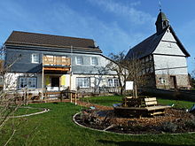
Schreufa from the south
|
|
Schreufa is a village about 3 km north of Frankenberg (Eder) in the Waldeck-Frankenberg district in Hesse . Today it is a district of Frankenberg (Eder).
Geographical location
Schreufa is located on the Nuhne , into which the Nienze opens on the northwestern outskirts . Below Schreufa, on the south-eastern outskirts, the Nuhne flows into the Eder . Between around 1590 and around 1820, copper marl was mined near Schreufa , mainly because of its silver content.
history
The place was first mentioned in a document as "Scroufi" in a document from 850. The place is also mentioned in 1016 and in a deed of donation from 1107 as a count Kunimund various possessions, including Schreufa, to the imperial abbey Hersfeld gave. Originally there were two localities, namely Ober- and Niederschreufa. In 1576 Niederschreufa became a desert when the last residents there moved to Oberschreufa. The Nuhnehof of the Lords of Nona was once located above Niederschreufa . In church terms, Schreufa was originally a branch of Geismar , then of Viermünden , where the von Dersch family had fiefdoms , so that at the time of the Reformation and also in the 17th century, Schreufa was affected by the frequent change of denomination of the Dersch family and their arbitrariness, albeit the Dersch the right of patronage in Schreufa also remained denied. Due to a legal dispute, the majority of the Schreufa house fathers converted to the Reformed religion in 1685. In 1690, the Reformed congregation built the church in Schreufa, which is still preserved today, as a subsidiary congregation of Frankenberg, while the numerically smaller Lutherans were given the old Butzkirche between Schreufa and Sachsenberg (demolished in 1817).
A few kilometers north of Schreufa in the Nuhne Valley , Konrad von Itter founded the Butzebach nunnery in 1242 , in a remote forest, the so-called "Butzebach". As early as 1249, however, the monastery was moved in front of the gates of the town of Frankenberg, founded by the Hessian Landgrave Konrad von Thuringia in 1233/1234 , to the place of the deserted Hadebrandsdorf.
On December 31, 1970 Schreufa was in the course of administrative reform in Hesse on a voluntary basis in the city Frankenberg (Eder) (former spelling Frankenberg-Eder ) incorporated .
In 2000, the place celebrated its 1150th anniversary with a week of festivities.
The old village school in Schreufa was renovated in an exemplary manner through voluntary work and transformed into the "Weather Museum Old School Schreufa" and village meeting point for cultural events. The museum shows memorabilia from Conrad Liese, who was a teacher in Schreufa in the first half of the 20th century and tried very hard to incorporate elements of weather science into school lessons. The museum opened in 2016.
politics
The current mayor is Henning Scheele.
Club life
In Schreufa, the volunteer fire brigade provides fire protection and general help. In the sporting field, there is a sports club founded in 1925 as TSV 1925 Viermünden and renamed in 1977 to “TSV Viermünden / Schreufa eV”. There is also a rural women's association. The men's choir merged in January 2015 with the MGV Frankenberg to form "Liedertafel Frankenberg 1902 / Schreufa 1875". There is also a shooting club that has its shooting range in the restaurant at the mill. The parents' association "Nuhne-Gänse" and the theater group "GanS anders" Schreufa were founded in the recent past.
traffic
The Schreufa stop was outside the town on the Korbach-Marburg railway line . It is no longer in use. The closest station is Frankenberg-Goßberg .
literature
- Insights into the history of Schreufa , Schreufa 1990
- Literature on Schreufa in the Hessian Bibliography
Individual evidence
- ↑ Schreufa, Waldeck-Frankenberg district. Historical local dictionary for Hessen. (As of July 8, 2020). In: Landesgeschichtliches Informationssystem Hessen (LAGIS).
- ↑ Population figures . In: website. City of Frankenberg, accessed August 2020 .
- ↑ Incorporation of the communities of Hommershausen, Rengershausen, Röddenau, Rodenbach, Schreufa, Viermünden and Wangershausen into the town of Frankenberg-Eder in the Frankenberg district on January 5, 1971 . In: The Hessian Minister of the Interior (Ed.): State Gazette for the State of Hesse. 1971 No. 3 , p. 111 , point 121 ( online at the information system of the Hessian state parliament [PDF; 5.5 MB ]).
- ↑ Schreufa Weather Museum
- ^ Districts of the city of Frankenberg. Data and contact person. In: website. City of Frankenberg (Eder), accessed April 2019 .
Web links
- Schreufa district. In: Website of the city of Frankenberg.
- Schreufa. Local history, information. Private website
- Schreufa, Waldeck-Frankenberg district. Historical local dictionary for Hessen. In: Landesgeschichtliches Informationssystem Hessen (LAGIS).


