Ojós
| Ojós municipality | ||
|---|---|---|

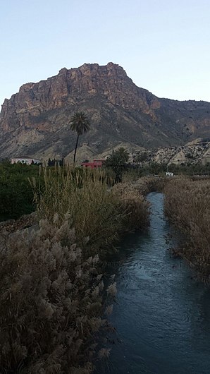
Río Segura near Ojós in the Valle de Ricote
|
||
| coat of arms | Map of Spain | |

|
|
|
| Basic data | ||
| Autonomous Community : |
|
|
| Comarca : | Valle de Ricote | |
| Coordinates | 38 ° 9 ′ N , 1 ° 21 ′ W | |
| Height : | 125 msnm | |
| Area : | 45.28 km² | |
| Residents : | 500 (Jan. 1, 2019) | |
| Population density : | 11.04 inhabitants / km² | |
| Postal code : | 30611 | |
| Municipality number ( INE ): | 30031 | |
| administration | ||
| Website : | Ojós | |
Ojós is a southern Spanish town and municipality ( municipio ) with a total of 500 inhabitants (as of January 1, 2019) in the center of the province of Murcia in the autonomous region of Murcia of the same name .
location
The place Ojós is located on the west bank of the Río Segura a good 32 km (driving distance) northwest of the city of Murcia at an altitude of about 125 m above sea level. d. The climate in winter is temperate, in summer it is warm to hot; the low amounts of precipitation (approx. 305 mm / year) fall - with the exception of the almost rainless summer months - distributed over the whole year.
Population development
| year | 1857 | 1900 | 1950 | 2000 | 2016 |
| Residents | 950 | 1,277 | 1,151 | 593 | 497 |
The continuous population decline since the second half of the 20th century is mainly due to the mechanization of agriculture and the associated loss of jobs.
economy
Ojós is located in the Valle de Ricote in the agriculturally used core zone of the province of Murcia - grain, grapevines as well as olive and fruit trees of all kinds were planted; Vegetables came from the house gardens. Today mainly peaches, apricots and citrus fruits are harvested. Small traders, craftsmen and service companies of all kinds have settled in the village. There are also several holiday homes (casas rurales) .
history
There are no prehistoric finds; on the other hand, small Iberian finds were made in the municipality. Remains of a late antique country estate ( villa rustica ) were also uncovered. In the years after 711 the area was overrun by the Moors , but parts remained under the rule of the Visigoth count (comes) Teodomiro († 743). The place Oxox seems a Moorish, i. H. to be Berber foundation. After the end of the Caliphate of Córdoba that arose Taifa Kingdom Murcia, which after the reconquest ( reconquista ) of the region by Castilian troops under Alfonso X in 1243 in a Christian kingdom was converted, which, however closely with the Crown of Castile was intertwined . The region of the Valle de Ricote was given to the Order of Santiago , but from 1296 to 1304 it came temporarily under Aragonese rule and in 1477 briefly under the rule of the Nasrid rulers of Granada . At the beginning of the 16th century, many Moors ( moriscos ) left the country; others stayed and were not until the beginning of the 17th century by decrees of Philip III. or his First Minister, the Duke of Lerma , expelled from the country, which had negative demographic and economic consequences for the region.
Attractions
- The small Iglesia de San Agustín , built in the 18th century, is the parish church of the village. The simple facade shows no particular style features. The interior of the church has a single nave, but has side chapels. In the flat-closing apse there is a classical altarpiece .
- Close to the river is an iron scoop wheel (noria) with a diameter of approximately 7 m, by means of which water was pumped to a higher level and into the subsequent irrigation channels.
Web links
- Ojós - photos, links + information (spanish)
Individual evidence
- ↑ Cifras oficiales de población resultantes de la revisión del Padrón municipal a 1 de enero . Population statistics from the Instituto Nacional de Estadística (population update).
- ↑ Ojós - map with altitude information
- ↑ Ojós - climate tables
- ↑ Ojós - population development
- ↑ Ojós - economy etc.
- ↑ Ojós - history
- ↑ Ojós - Iglesia de San Agustín
- ↑ Ojós - bucket wheel
