
Opawa (Lubawka)
| Opawa | |||
|---|---|---|---|
 Help on coat of arms |
|
||
| Basic data | |||
| State : | Poland | ||
| Voivodeship : | Lower Silesia | ||
| Powiat : | Kamienna Góra | ||
| Geographic location : | 50 ° 42 ' N , 15 ° 54' E | ||
| Residents : | |||
| Telephone code : | (+48) 75 | ||
| License plate : | DKA | ||
| Economy and Transport | |||
| Street : | Lubawka - Kowary | ||
| Next international airport : | Wroclaw | ||

Opawa (German Oppau ) is a district of the rural community Lubawka ( Liebau ) in the powiat Kamiennogórski in the Lower Silesian Voivodeship in Poland.
geography

Opawa is located in the southern Giant Mountains on the Oppau ( Opawa ), a left tributary of the Bober . It is reached via a cul-de-sac from Miszkowice that ends in Niedamirów . Neighboring places are Jarkowice ( Hermsdorf ) in the north, Miszkowice and Paprotki ( urban Hartau ) in the northeast, Lubawka in the west and Niedamirów in the southwest. Across the border with the Czech Republic, which runs east, south and west, lies Žacléř in the south . It can be reached via the Lubawka– Královec border crossing .
history
The area around Oppau initially belonged to Bohemia and passed to Duke Bolko I in the 13th century . Together with the Duchy of Schweidnitz , it became part of the Crown of Bohemia in 1368 and, along with Buchwald , Tschöpsdorf and Kunzendorf, belonged to Marita von Se (i) dlitz as a widow estate , a court master of the Duchess Agnes . In 1378, Marita's sons Hans Schonevogel and Kuncze Hudner Oppau and the other towns mentioned with all their property and rights sold to the Cistercian monastery of Grüssau . In order to pay the Turkish tax , Oppau with Kunzendorf, Tschöpsdorf and Buchwald had to be pledged in 1558. Lutheranism developed in the villages during the pledge period . From 1568, the Lutheran preacher Johannes Hintzius was active as pastor in Oppau, who previously worked in Trautenau . In 1570 Abbot Caspar Hauser (1567–1571) granted the Oppauer Schulzen the right to open up the coal mine that had been discovered.
After the First Silesian War , Oppau fell to Prussia in 1742, along with most of Silesia . In 1810 the monastery property was secularized . After the reorganization of Prussia in 1815, Oppau belonged to the province of Silesia and from 1816 was incorporated into the Landeshut district, with which it remained connected until 1945. It formed its own rural community and was the seat of the Oppau district since 1874, which also included the rural communities Kunzendorf (now Niedamirów ) and Tschöpsdorf (now Szczepanów ) as well as the manor district Oppau-Kunzendorf. In 1939 there were 566 inhabitants in Oppau.
As a result of the Second World War , Oppau fell to Poland in 1945, like almost all of Silesia, and was renamed Opawa . The German population was largely expelled . Some of the new residents were displaced from eastern Poland . 1975-1998 Opawa belonged to the Jelenia Góra Voivodeship .
Attractions

- The Catholic branch church St. Hedwig was built as a chapel in 1687–1692 on the site of a previous building, converted into a church in 1794–1795 and rebuilt after a fire in 1905. It has a rich baroque interior. The architectural main altar with framing was created by the Grüssau sculptor Joseph Anton Lachel before 1785 , from whose workshop the pulpit, the three-tower organ prospect and the confessional with a crucifixion group in the crown probably also come. The main altar painting of St. Hedwig is from 1863; it was painted by JC Schall. The late Gothic font dates from the end of the 16th century. The baptismal font is decorated with an abbey coat of arms of the Grüssau Cistercians.
- On the outside walls of the church there are three epitaphs from the 17th and 18th centuries. Century.
- The former Schulzengut is in a poor structural condition.
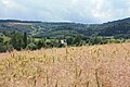
Surroundings of Opawa

Branch church St. Hedwig

literature
- P. Ambrosius Rose: Grüssau Monastery . Stuttgart 1974, ISBN 3-8062-0126-9 , pp. 35, 56 and 57
- Dehio -Manual of Art Monuments in Poland Silesia . Munich / Berlin 2005, ISBN 3-422-03109-X , p. 701