Orge (Seine)
| Orge | ||
|
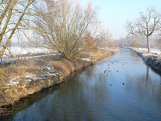
The Orge at Brétigny-sur-Orge |
||
| Data | ||
| Water code | FR : F46-0400 | |
| location | France , Île-de-France region | |
| River system | His | |
| Drain over | Its → English Channel | |
| source | in the municipality of Saint-Martin-de-Bréthencourt, 48 ° 30 ′ 31 ″ N , 1 ° 55 ′ 11 ″ E |
|
| Source height | approx. 130 m | |
| muzzle | at Athis-Mons in the Seine coordinates: 48 ° 42 ′ 41 ″ N , 2 ° 24 ′ 14 ″ E 48 ° 42 ′ 41 ″ N , 2 ° 24 ′ 14 ″ E |
|
| Mouth height | approx. 30 m | |
| Height difference | approx. 100 m | |
| Bottom slope | approx. 1.9 ‰ | |
| length | 53 km | |
| Catchment area | 952 km² | |
| Drain |
MQ |
4 m³ / s |
| Left tributaries | Rémarde | |
| Right tributaries | Yvette | |
| Medium-sized cities | Savigny-sur-Orge , Viry-Châtillon , Athis-Mons | |
| Small towns | Dourdan , Breuillet , Égly , Arpajon , Saint-Germain-lès-Arpajon , Brétigny-sur-Orge , Saint-Michel-sur-Orge , Longpont-sur-Orge , Épinay-sur-Orge , Villemoisson-sur-Orge , Juvisy- sur-Orge | |
The Orge is a river in France that runs in the Île-de-France region . It rises in the municipality of Saint-Martin-de-Bréthencourt . The Orge generally drains in a north-easterly direction and flows into the Seine as a left tributary after 53 kilometers at Athis-Mons , southeast of Paris-Orly airport . A second estuary reaches the Seine around four kilometers upstream, at Viry-Châtillon . On its way, the river crosses the Yvelines and Essonne departments . Its lower reaches lead through a densely populated area with around 370,000 inhabitants in the greater Paris area.
Places on the river
- Saint-Martin-de-Bréthencourt
- Dourdan
- Breuillet
- Égly
- Arpajon
- Saint-Germain-lès-Arpajon
- Brétigny-sur-Orge
- Saint-Michel-sur-Orge
- Longpont-sur-Orge
- Épinay-sur-Orge
- Villemoisson-sur-Orge
- Savigny-sur-Orge
- Juvisy-sur-Orge
- Viry-Châtillon
- Athis-Mons
Web links
Commons : Orge - collection of images, videos and audio files
