Osmangazi
| Osmangazi | ||||
|
||||
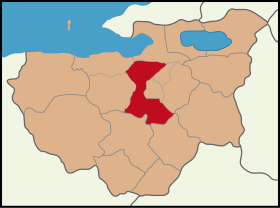
 Location of Osmangazi within Bursa |
||||
| Basic data | ||||
|---|---|---|---|---|
| Province (il) : | Bursa | |||
| Coordinates : | 40 ° 8 ' N , 29 ° 11' E | |||
| Height : | 150 m | |||
| Telephone code : | (+90) 224 | |||
| Postal code : | 16010-16370 | |||
| License plate : | 16 | |||
| Structure and administration (as of 2019) | ||||
| Structure : | 137 Mahalles | |||
| Mayor : | Mustafa Dündar ( AKP ) | |||
| Postal address : | Santral Garaj Mah. Ulubatli Hasan Blv. No: 10 16140 Osmangazi / Bursa |
|||
| Website: | ||||
| Osmangazi County | ||||
| Residents : | 862,516 (2018) | |||
| Surface: | 621 km² | |||
| Population density : | 1,389 inhabitants per km² | |||
| Kaymakam : | Zafer Orhan | |||
| Website (Kaymakam): | ||||
Osmangazi is a town in the district of the same name in the Turkish province of Bursa and at the same time the most populous district of the Büyükşehir belediyesi Bursa (metropolitan municipality / metropolitan province ) created in 1986 . Osmangazi is located on the southwestern outskirts of the provincial capital.
The area around Osmangazi has been inhabited since approximately 4000 BC. The first mention is found around 700 BC. With reference to the landscape of Mysia . The Demirtaş dam is located in the northeast of the district .
Since a regional reform in 2013, the Ilçe (district) has been identical in area and population to the district town. The 110 Mahalles (districts) of the district town (Ilçe merkezi) were preserved, in addition the 27 villages of Köy were converted into Mahalles. Thus, the number of mahalles for this Ilçe rose to 137.
Web links
- -ilce-nufusu-bursa Mahallelere Göre Bursa Osmangazi (list of all districts from 2013, with population and gender)
- Osmangazi Mahalleleri Nüfusu Bursa (List of all districts 2012-2018, with population figures )
- at Facebook
- on Twitter
Individual evidence
- ↑ Nufusu.com Türkiye Nüfusu , accessed on September 10, 2019


