
Osning route
| Osning route | |
|---|---|
| Length: | 187 km |
| State: | Lower Saxony |
| Course direction: | Ring guide |
| Start: | Osnabrück |
| The End: | Osnabrück |
The Osning Route is an 187 km long holiday route in and around Osnabrück , which essentially runs through the south of the Osnabrück district . Osning is the old name of the Teutoburg Forest .
The road is designed as a ring route and is largely located in the TERRA.vita nature and geopark . It crosses the Lower Saxony sections of the Teutoburg Forest and the Wiehengebirge . The route begins in Osnabrück and leads via Bissendorf , Hilter , Georgsmarienhütte , Hasbergen , Hagen , Bad Iburg , Glandorf , Bad Laer , Bad Rothenfelde , Dissen , Melle , Bad Essen , Bohmte , Ostercappeln , Schledehausen and Belm back to Osnabrück.
Along the route you can see Iburg Castle , built as a monastery by Prince Bishop Benno II of Osnabrück in 1073, as well as a large number of moated castles and palaces of the local landed gentry as well as the facilities of the four health resorts Bad Iburg, Bad Laer, Bad Rothenfelde and Bad Essen . In spring, a large number of cherry trees bloom in Hagen, in autumn the broad-leaved deciduous trees of the low mountain range change color on both sides of the route. The Bad Essen spa gardens and the park of Ippenburg Palace were the venues for the Lower Saxony State Horticultural Show 2010, the Charlottenseepark at the foot of the Iburger Schloss and the Waldkurpark were the venues for the Lower Saxony State Horticultural Show 2018 .

Cherry blossom in the Hagen trout valley

Iburg Castle
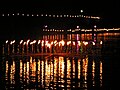
"Festival of 1000 torches" at the Glockensee Bad Laer

New graduation tower Bad Rothenfelde

Dinosaur tracks in Barkhausen

Bad Essen spa park with a small graduation tower built in 2010

Schelenburg in Schledehausen


Web links
- City of Osnabrück: Osning Route: Emperors, Kings and Princes ( Memento from March 27, 2008 in the Internet Archive )
- Osnabrück district: Osning route