Tüngental
|
Tüngental
City of Schwäbisch Hall
|
|
|---|---|
| Coordinates: 49 ° 7 ′ 19 ″ N , 9 ° 48 ′ 56 ″ E | |
| Height : | 382 (305-423) m above sea level NN |
| Incorporation : | January 1, 1972 |
| Area code : | 07907 |
|
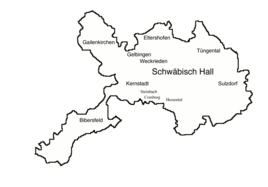
Districts of Schwäbisch Hall, Tüngental north of the city center
|
|
|
Destruction of Tüngental (right) and Altenhausen in the "City War" in 1449
|
|
Tüngental is a district of Schwäbisch Hall .
Surname
In the regional dialect the village is called Dingldâ [ ˈdɪŋlˌdə ].
geography
Tüngental is one of the largest districts of Schwäbisch Hall in terms of area, it occupies part of the Haller level northeast of the city itself and extends in this direction to the upper left edge of the steeply incised lower Bühler valley. The eponymous main town is located about six kilometers east-northeast of the city center of Hall and is in east-west direction from Otterbach crossed, the first forms a significant valley in the local area and then into his shell - blade continues to Buhler. The much smaller suburbs Altenhausen, Veinau, Ramsbach, Wolpertsdorf and Otterbach are located at distances of between one and a half and two and a half kilometers around it on an arc from west to north to east. Veinau in the north-west drains over the Ölklingenbach to the Kocher , Wolpertsdorf in the north-east is already below the slope shoulder on the Bühlertal slope, the others are all in the catchment area of the Otterbach.
The landscape in the district is flat to flat hilly in the west, hilly in the east, here the blades of Otterbach and the converging Rotbach furrow the plateau. There is a somewhat closed forest in its steep valleys, as well as in the northern tip of the district area. In front of this there are some forest islands around Ramsbach, as can be found in its eastern tip west above Oberscheffach . The majority of the area, however, is open landscape, on which arable farming is carried out with good drainage.
history
Tüngental was probably founded by the Carolingians . The place name Dungetal appears around 1100 in the Komburg donation book and indicates an old gracious property . The Vogt of Komburg Abbey also held the court day there.
King Ludwig IV documents here in 1316. In 1449 the town was burned down in the war between cities. There must have been one or more noble seats in the village. The nobles of Brunnen-Hopfach, those of Ramsbach and those of Hürlebach, from the von Enslingen family, lived in Tüngental in the 15th century and were buried near the Marienkirche .
The place came almost entirely to the imperial city of Hall at the end of the Middle Ages . As a result, Tüngental became part of the Haller land territory and was subordinate to the Halle office (In der) Schlicht .
After the dissolution of the imperial city and the takeover of the Haller rural areas by Württemberg in 1802, the community belonged to the newly founded Württemberg Oberamt Hall , from which the district of Hall emerged in 1934 and the district of Schwäbisch Hall in 1941.
In 1945 Tüngental was destroyed along with the church in the Second World War .
On January 1, 1972, it was incorporated into Schwäbisch Hall together with the associated hamlets of Altenhausen , Otterbach , Ramsbach , Veinau and Wolpertsdorf .
Parcels belonging to Tüngental
- Hamlet Altenhausen
- Hamlet Otterbach
- Hamlet of Ramsbach
- Hamlet of Veinau
- Hamlet Wolpertsdorf with the Bielriet castle ruins
Local transport
Tüngental is usually served by the city bus line 5 Schwäbisch Hall – Ilshofen of the roundabout Schwäbisch Hall at up to two stops and to a minor extent also by line 12.
On weekdays, city bus No. 5 stops out of town between 7:25 a.m. and 7:28 p.m. about two dozen times. There are few more stops in the city and the service times are earlier between 6:25 a.m. and 6:55 p.m. On Saturdays, the bus stops around ten times in each direction with reduced traffic times, and on Sundays only eight times. There is also the night bus, which only drives out of town and stops daily between 10:30 p.m. and 11:00 p.m.
At the weekend there are also eight buses on line 12 via Tüngental in both directions and on both days.
Individual evidence
- ^ Federal Statistical Office (ed.): Historical municipality directory for the Federal Republic of Germany. Name, border and key number changes in municipalities, counties and administrative districts from May 27, 1970 to December 31, 1982 . W. Kohlhammer, Stuttgart / Mainz 1983, ISBN 3-17-003263-1 , p. 456 .
- ↑ Timetable for line 5 (PDF, 152 kByte) of the Schwäbisch Hall roundabout, valid from December 14, 2014.
- ↑ Timetable of line 12 (PDF, 47 kByte) of the Schwäbisch Hall roundabout, valid from December 14, 2014. The sporadic traffic on this line into the Bühlertal via Tüngental on weekends is only noted in the header with the traffic restrictions, there are separate timetable lines for Tüngental stops it no.
literature
- Eugen Gradmann : The art and antiquity monuments of the city and the Oberamt Schwäbisch-Hall . Paul Neff Verlag, Esslingen a. N. 1907, OCLC 31518382 , pp. 174-175 ( archive.org ).
Web links
- The story of Tüngental
- Map of Tüngental to: State Institute for the Environment Baden-Württemberg (LUBW) ( information )
- List of sub-locations on the website of the city of Schwäbisch Hall


