
Pesch (Erkelenz)
|
Pesch
City of Erkelenz
Coordinates: 51 ° 3 ′ 16 ″ N , 6 ° 27 ′ 23 ″ E
|
|
|---|---|
| Height : | 94 m |
| Residents : | 0 (Jul 31, 2014) |
| Postal code : | 41812 |
| Area code : | 02431 |
 Location of Pesch in the Rhenish lignite district
|
|

Pesch was a district of Erkelenz in the district of Heinsberg in North Rhine-Westphalia . It belonged to district 9 of the city of Erkelenz. Pesch was the eastern Garzweiler of RWE Power dredged after the relocation of the residents. A closed resettlement did not take place. Some of the local residents have settled in Pescher Kamp, a new development in Kückhoven .
geography
location
Alt-Immerath, to the west of Pesch, is separated from Pesch by the A 61 . To the north of Pesch were the Jüchen districts of Otzenrath and Spenrath , which have also been relocated and have already been dredged. Garzweiler used to be to the east, and it has also been relocated and dredged. Jackerath is in the south .
geology
Underground several lignite are seams in the Tertiary . The surface is covered with loess .
Type of settlement
Pesch was created as a street village along the road from Immerath to Garzweiler.
history

The St. Gereon Abbey of Cologne owned a farm in Pesch from 1300 to 1802.
In the Middle Ages Pesch belonged to the Dingstuhl Holzweiler in the office of Kaster of the Duchy of Jülich .
From 1798 the village was in the French Mairie Immerath and from 1816 in the Prussian mayor's office of the same name.
Between 1858 and 1936 Pesch had its own school. Then the Pesch children attended the Immerather four-class school.
The relocation of the village officially began in 2006 and was completely demolished for the expansion of the Garzweiler opencast mine.
In 2010 the demolition of Haus Pesch and five other houses at the eastern end of the street "In Pesch" began. Some trees on streets and in gardens were cleared in 2011. In July 2011 more houses on the main street "In Pesch" were demolished, the demolition progressed from east to west. At the beginning of the year three households were still inhabited, in October of the same year two more. In autumn the figures, inscriptions and roof construction of the walkway were dismantled. Numerous trees were also cleared on the former railway line, as well as in town. On April 17, 2014, the last houses in Pesch were demolished.
Place name
Pesch had a different place name until the 17th century. It was called Werretsrath . This name was first mentioned as werencenrode in 1265. It is made up of Werin from the personal name Werinher , the diminutive ikin or chin and the basic word reod . The name means clearing of the Werenken or Werenchen. The village got its name from the manor of the same name, which is located on the western edge of the village. Only in the second half of the 17th century was the old place name replaced by the name Pesch.
Population development
The population of Pesch remained relatively constant in the 19th and 20th centuries:
| year | 1767 | 1819 | 1849 | 1871 | 1895 | 1905 | 1961 | 1970 | 1995 | 2005 | 2007 | 2009 | 2012 |
| Ew. | 120 | 234 | 240 | 243 | 198 | 256 | 212 | 230 | 230 | 65 | 53 | 29 | 0 |
Attractions

- House Pesch , a former knight's seat . The complex consisted of a bailey and a main house. In the 19th century, moats surrounded both parts of the building. In the end there were only trenches on the east and north sides of the complex. Haus Pesch was used as a farm until 2009. A gatehouse with a tower hood and coat of arms stone afforded a view of the inner courtyard. In the Middle Ages there was a chapel on Haus Pesch, which was consecrated to St. George . In 2010 the demolition of the historic courtyard began.
- In a park next to Haus Pesch, its owners built a Bauhaus style villa in 1934/1935 , designed by the Düsseldorf architect and artist Walter von Wecus .
- In front of the house 'In Pesch 42' (formerly L. + B. Zimmermann) stood a wayside shrine that had been rebuilt in 1996 for the wayside shrine that was destroyed during the construction of a residential house. The mother of God figure and the baby Jesus in her arms are original and date from the end of the 19th century.
photos

The street village of Pesch and the Pesch house on the tranchot map from 1806

Gatehouse and manor house Pesch


Bucket wheel excavator on the eastern outskirts
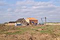
The last buildings of Pesch - excavators in the background, April 2014


literature
- Karl L. Mackes: Erkelenzer Börde and Niersquellgebiet. (= Series of publications by the city of Erkelenz , No. 6.) Mönchengladbach 1985, pp. 249–263.
Individual evidence
- ↑ Own observation
- ↑ Population figures (1867-1970 according to Karl L. Mackes: Erkelenzer Börde and Niersquellgebiet. (= Series of publications of the city of Erkelenz , No. 6.) Mönchengladbach 1985, p. 249)
- ↑ For 2009 in: Mario Emonds: Alt-Pesch - This is how the village dies ( Memento of the original from May 24, 2009 in the Internet Archive ) Info: The archive link was inserted automatically and has not yet been checked. Please check the original and archive link according to the instructions and then remove this notice. on rp-online.de from May 23, 2009, accessed on August 23, 2017.
Web links
- Documentation Garzweiler - overview "Pesch"
- Website of the city of Erkelenz
- Monuments in the city of Erkelenz
- Churches and chapels in the city of Erkelenz

Bellinghoven |
Berverath |
Borschemich (new) |
Commerden |
Erkelenz |
To go |
Geneiken |
Gerderath |
Gerderhahn |
Golkrath |
Granterath |
Hetzerath |
Holzweiler |
Houverath |
Immerath (new) |
Cat |
Keyenberg |
Kleinbouslar |
Kückhoven |
Cuckum |
Lövenich |
Lützerath |
Matzerath |
Mennekrath |
Oberwestrich |
Oerath |
Oestrich |
Scheidt |
Schwanenberg |
Tenholt |
Terheeg |
Lesson |
Venrath |
Wockerath
Former districts
Borschemich († 2017) |
Immerath († 2018) |
Pesch († 2014)