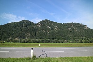
Pfaffenkogel (Grazer Bergland)
| Pfaffenkogel | ||
|---|---|---|
|
Pfaffenkogel (summit left) from the east |
||
| height | 734 m above sea level A. | |
| location | Styria , Austria | |
| Mountains | Grazer Bergland , Lavanttal Alps | |
| Dominance | 1.7 km → Gamskogel | |
| Notch height | 166 m ↓ Hörgass saddle | |
| Coordinates | 47 ° 9 '56 " N , 15 ° 18' 35" E | |
|
|
||
| rock | Dolomites | |
| Age of the rock | Devon | |
| particularities | Nature reserve | |
The Pfaffenkogel is 734 m above sea level. A. high mountain in the western part of the Grazer Bergland in the Austrian state of Styria . It is located in the south of the market town of Deutschfeistritz and can be crossed on a hiking trail.
Location and surroundings
The Pfaffenkogel rises on the right bank around 350 meters above the Mittlerer Mur valley south of Kleinstübing . It forms the highest of several peaks in a small mountain ridge that extends from the mouth of the Stübingbach to the Hörgassattel ( 568 m ). The ridge is bounded in the northwest by the lower Stübingtal with the district Dielach and in the south by the Graben des Enzenbach with the Stübing open-air museum . To the east, towards the Murtal, the wooded terrain slopes down steeply with several torrents that sometimes carry water . The Pfaffenkogel, together with the Gsollerkogel to the south, has formed the 719 hectare Pfaffenkogel-Gsollerkogel nature reserve since 1964 .
Geology and geomorphology
The mountain is of bright and dark gray Dolomite constructed within said Graz Paleozoic the Rannach - facies belong. A profile of the south-eastern slope of the mountain provided more precise information about the geological structure in the mid-1970s. According to this, the Pfaffenkogel consists of a relatively well-exposed alternating layer of laminated to decimeter-banked dolomites including numerous stromatolite layers with massive, meter-thick, chunky dolomites. The first unit is of intertidal origin , the second more shallow, subtidal or lagunar in origin. The change of these units is expressed morphologically in step-shaped gradations, with the laminated dolomites leveling and the massive dolomites forming rugged walls. Secondary bare karst developed on deforested areas .
Ascent
The Pfaffenkogel can be reached from two sides via a marked hiking trail. It takes about an hour to get to the summit from Stübing train station via the steep north side of the mountain. The less arduous ascent from the Hörgassattel (Hörgaspauli) takes about three quarters of an hour. The crossing of the Pfaffenkogel is a variant of the Grazer Umland-Weg and can be combined with a previous visit to the open-air museum to a circular hike.
In addition, a rock section in the north-eastern flank of the mountain offers the possibility of a short climbing tour. The Rudlweg, rated IV + , should, however, be avoided due to its unclear hiking trail status with regard to the Nature Conservation Act. In contrast to the actual summit, there is a small summit cross on the top of the rock .
Literature and maps
- Günter and Luise Auferbauer: Graz local mountains with Mur and Mürz valleys . Bergverlag Rother , Munich 2000, ISBN 3-7633-4292-3 , pp. 54-55.
- Austrian map 1: 50,000, sheet 4228 ( UTM ). Federal Office for Metrology and Surveying .
- Freytag & Berndt Vienna , hiking map 1: 50,000, WK 132, Gleinalpe & Lipizzanerheimat - Leoben - Voitsberg , 978-3850848039.
Web links
Individual evidence
- ↑ NSG-a06 Pfaffenkogel - Gsollerkogel. State of Styria , accessed on July 27, 2020 .
- ↑ Digital Atlas of Styria: Geology & Geotechnics. State of Styria , accessed on July 27, 2020 .
- ↑ Alois Fenninger & Hans Ludwig Holzer: The genesis of the dolomite sandstone series of the Graz Paleozoic. In: Communications of the Austrian Geological Society , Volume 69, Vienna 1978, pp. 109–162. Online PDF , accessed July 27, 2020.
- ↑ Helmut wing : The geology of the Grazer Bergland. In: Communications from the Department of Geology, Paleontology and Mining at the Landesmuseum Joanneum , Graz 1975, p. 230. Online PDF , accessed on July 27, 2020.
- ↑ Rudlweg - Pfaffenkogel. Bergstieg.com, accessed July 27, 2020 .


