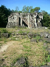
Phanna Nikhom district
|
Phanna Nikhom พรรณนา นิคม |
|
|---|---|
| Province: | Sakon Nakhon |
| Surface: | 673.798 km² |
| Residents: | 79,871 (2013) |
| Population density : | 118 U / km² |
| ZIP : | 47130, 47220 |
| Geocode : | 4704 |
| map | |

|
|
Amphoe Phanna Nikhom ( Thai อำเภอ พรรณนา นิคม ) is a district ( Amphoe - Administrative District) in the Province of Sakon Nakhon . The province of Sakon Nakhon is located in the northeast region of Thailand , the so-called Isan .
geography
The Amphoe Phanna Nikhom is located in the center of the province of Sakon Nakhon and is bordered clockwise from the south by the Amphoe Mueang Sakon Nakhon , Kut Bak , Nikhom Nam Un , Waritchaphum , Phang Khon , Wanon Niwat and Akat Amnuai in the province of Sakon Nakhon, as well as Amphoe Na Wa of Nakhon Phanom Province .
history
Amphoe Phanna Nikhom originated from Ban Phang Phrao ( บ้าน พัง พร้าว ), as the area was originally called before it was given its current name in 1902.
Culture
Two of the most important cultural monuments of the Sakon Nakhon province are located in the Phu Phan Mountains in Amphoe Phanna Nikhon: Prasat Phu Phek , the ruins of a temple from the Khmer period, and Wat Tham Kham , the memory of the monk Ajahn Thate Desaransi / Luang Pu Thet Thetrangsi ( หลวง ปู่ เท ส ก์ เท ส รังสี ).
administration
Provincial Administration
Phanna Nikhom County is divided into ten tambon ("subdistricts" or "parishes"), which are further subdivided into 135 muban ("villages").
| No. | Surname | Thai | Muban | Pop. |
|---|---|---|---|---|
| 1. | Phanna | พรรณา | 13 | 8,767 |
| 2. | Wang Yang | วัง ยาง | 13 | 8,112 |
| 3. | Phok Noi | พอก น้อย | 12 | 8,552 |
| 4th | Well, Hua Bo | นา หัว บ่อ | 19th | 9,951 |
| 5. | Rai | ไร่ | 16 | 9,404 |
| 6th | Chang Ming | ช้าง มิ่ง | 18th | 8,893 |
| 7th | Well nai | นา ใน | 11 | 7,677 |
| 8th. | Sawang | สว่าง | 13 | 7,236 |
| 9. | Ba Hi | บะ ฮี | 10 | 6.225 |
| 10. | Choeng Chum | เชิง ชุม | 10 | 5,054 |
Local administration
There are eight municipalities with "small town" status ( Thesaban Tambon ) in the district:
- Phanna Nakhon (Thai: เทศบาล ตำบล พรรณา นคร ), consisting of parts of the Tambon Phanna.
- Wang Yang (Thai: เทศบาล ตำบล วัง ยาง ), consisting of the entire tambon Wang Yang.
- Phok Noi (Thai: เทศบาล ตำบล พอก น้อย ), consisting of the entire Tambon Phok Noi.
- Na Hua Bo (Thai: เทศบาล ตำบล นา หัว บ่อ ), consisting of the entire tambon Na Hua Bo.
- Rai (Thai: เทศบาล ตำบล ไร่ ), consisting of the entire Tambon Rai.
- Na Nai (Thai: เทศบาล ตำบล นา ใน ), consisting of the entire Tambon Na Nai.
- Bua Sawang (Thai: เทศบาล ตำบล บัว สว่าง ), consisting of the entire Tambon Sawang.
- Phanna Nikhom (Thai: เทศบาล ตำบล พรรณานิคม ), consisting of the remaining parts of the Tambon Phanna.
There are also three " Tambon Administrative Organizations " ( องค์การ บริหาร ส่วน ตำบล - Tambon Administrative Organizations, TAO):
- Chang Ming (Thai: องค์การ บริหาร ส่วน ตำบล ช้าง มิ่ง )
- Ba Hi (Thai: องค์การ บริหาร ส่วน ตำบล บะ ฮี )
- Choeng Chum (Thai: องค์การ บริหาร ส่วน ตำบล เชิง ชุม )
Individual evidence
- ↑ 2013 population statistics ( Thai ) Department of Provincial Administration. Retrieved August 3, 2014.
Web links
Coordinates: 17 ° 21 ' N , 103 ° 51' E


