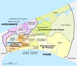
Pikine Ouest
| Pikine Ouest Commune d'arrondissement Pikine Ouest |
|
|---|---|
| Coordinates | 14 ° 45 '11 " N , 17 ° 23' 58" W |
 The 16 communes d'arrondissement in Pikine The 16 communes d'arrondissement in Pikine
|
|
| Basic data | |
| Country | Senegal |
| Dakar | |
| Department | Pikins |
| ISO 3166-2 | SN-DK |
| Arrondissement | Arrondissement de Pikine Dagoudane |
| height | 27 m |
| surface | 6.1 km² |
| Residents | 52,154 (2013) |
| density | 8,549.8 Ew. / km² |
Pikine Ouest is one of the 16 districts (Communes d'arrondissement du Sénégal) of Pikine , which is Senegal's largest city before the capital Dakar .
geography
Pikine Ouest is located in the center of the bottleneck of the Cap-Vert peninsula , bounded in the south by the Dalifort district and in the west and north by the neighboring town of Guédiawaye . The east-west extension of the district is over three kilometers, the south-north extension almost three kilometers.
In the south, the district border follows the course of the N 1 . The demarcation to the northeast bordering city districts Pikine Nord and Pikine Est follows the rue PO 02 .
The municipality has an area of 6.1 km². This makes it the largest urban district in terms of area in the west of the city, but primarily includes the large Ramsar reserve Grande Niaye de Pikine on the border with the neighboring town of Guédiawaye . Only an area of around 1.87 km² and approximately diamond-shaped delimited southeast of the wetlands can be built on, and it is fully built up and densely populated. In the wetland, the Technopole urban development project was implemented before it was placed under protection . A wastewater treatment plant was also built here.
population
The last censuses showed the following population figures for the city district:
| year | Residents |
|---|---|
| 1988 | ... |
| 2002 | 44 266 |
| 2013 | 52 154 |
Individual evidence
- ^ City districts of Pikine in Monographie de Dakar 2014 page 5 of the PDF file 4.4 MB
- ↑ Estimation of the population of Dakar par collectivité locale en 2004 Area of the city districts on page 166 of the PDF file 1.12 MB
- ↑ Measure areas with google maps
- ↑ ANSD: Résultats préliminaires du Troisième Recensement Général de la Population et de l'Habitat du Sénégal de 2002 (RGPH-III) ( Memento of September 28, 2007 in the Internet Archive ) City districts of Pikine with statistics on their population Page 9 of the PDF File 1.64 MB
- ↑ ANSD: Rapport Projection de la Population du Senegal 2013–2063 (RGPHAE 2013) Figures for 2013, pages 21–22 of the PDF file 1.44 MB