Pikine Est
| Pikine Est Commune d'arrondissement Pikine Est |
|
|---|---|
| Coordinates | 14 ° 45 '20 " N , 17 ° 23' 26" W |
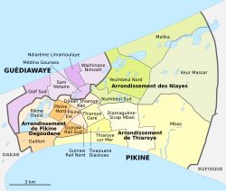
 The 16 communes d'arrondissement in Pikine The 16 communes d'arrondissement in Pikine
|
|
| Basic data | |
| Country | Senegal |
| Dakar | |
| Department | Pikins |
| ISO 3166-2 | SN-DK |
| Arrondissement | Arrondissement de Pikine Dagoudane |
| height | 16 m |
| surface | 1 km² |
| Residents | 32,452 (2013) |
| density | 32,452 Ew. / km² |
Pikine Est is one of the 16 districts (Communes d'arrondissement du Sénégal) of Pikine , the largest city in Senegal even before the capital Dakar .
geography
Pikine Est is located in the center of the bottleneck of the Cap-Vert Peninsula, long and narrow, between the Pikine Nord district and the Dakar – Niger railway line .
The approximately trapezoidal boundaries of the city district have an area of 1.0 km² with a length of around 1100 meters and an average width of around 420 meters. It is completely built up and very densely populated.
The border with Pikine Nord follows the Tally Boubess road . The Route des Niayes forms the demarcation from the northeastern neighboring district Djidah Thiaroye Kao . The Pikine Ouest neighborhoods start across Rue PO 02 . Beyond the railway line are the districts of Guinaw Rail Nord and Guinaw Rail Sud .
population
The last censuses showed the following population figures for the city district:
| year | Residents |
|---|---|
| 1988 | ... |
| 2002 | 31 290 |
| 2013 | 32 452 |
Individual evidence
- ^ City districts of Pikine in Monographie de Dakar 2014 page 5 of the PDF file 4.4 MB
- ↑ Estimation of the population of Dakar par collectivité locale en 2004 Area of the city districts on page 166 of the PDF file 1.12 MB
- ↑ ANSD: Résultats préliminaires du Troisième Recensement Général de la Population et de l'Habitat du Sénégal de 2002 (RGPH-III) ( Memento of September 28, 2007 in the Internet Archive ) City districts of Pikine with statistics on their population Page 9 of the PDF File 1.64 MB
- ↑ ANSD: Rapport Projection de la Population du Senegal 2013–2063 (RGPHAE 2013) Figures for 2013, pages 21–22 of the PDF file 1.44 MB