Dalifort
| Dalifort Commune d'arrondissement Dalifort |
|
|---|---|
| Coordinates | 14 ° 44 '28 " N , 17 ° 25' 5" W |
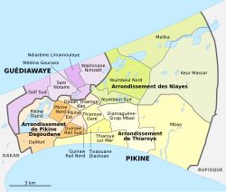
 The 16 communes d'arrondissement in Pikine The 16 communes d'arrondissement in Pikine
|
|
| Basic data | |
| Country | Senegal |
| Dakar | |
| Department | Pikins |
| ISO 3166-2 | SN-DK |
| Arrondissement | Arrondissement de Pikine Dagoudane |
| height | 14 m |
| surface | 3.1 km² |
| Residents | 30,418 (2013) |
| density | 9,812.3 Ew. / km² |
Dalifort is one of the 16 districts (Communes d'arrondissement du Sénégal) of Pikine , the largest city in Senegal even before the capital Dakar and the only one that borders it.
geography
Dalifort is located in the bottleneck of the Cap-Vert Peninsula between the Baie de Hann in the south and the Ramsar reserve Grande Niaye de Pikine in the north. The east-west extension of the district is around 2300 meters, the south-north extension around 1400 meters.
In the north, the district border follows the course of the N 1 . To the north are the neighboring town of Guédiawaye and the districts of Pikine Ouest and Guinaw Rail Sud . Dalifort has grown together structurally with the neighboring district of Thiaroye sur Mer and the district of Hann-Bel Air in the neighboring metropolis of Dakar .
The municipality has an area of 3.1 km². and is almost completely built up. Nonetheless, the average population density is relatively moderate, as the coastal strip up to Route de Rufisque and the area east of the access road to the Guédiawaye Pikine junction of Autoroute 1 consists mainly of industrial and commercial areas.
population
The last censuses showed the following population figures for the city district:
| year | Residents |
|---|---|
| 1988 | ... |
| 2002 | 19 963 |
| 2013 | 30 418 |
Infrastructure and traffic
The city district has a junction with the toll road 1 in the northeast on the road to Guédiawaye . This provides a fast connection to the new Dakar-Blaise Diagne Airport . North of the A1, in places directly side by side with it, runs the N 1 national road, which has four lanes but is not free of intersections, on the way from the port metropolis of Dakar to the interior.
Parallel to the Route de Rufisque and side by side with it, the Dakar – Niger railway runs through the city district. For passenger traffic there is a train station called Yarakh in Dalifort .
In the east of Dalifort, SOGAS (Société de gestion des Abattoirs du Sénégal) , formerly known as SERAS, operates the largest slaughterhouse and meat wholesale market in Senegal. Next door is the Marché central du poisson fish wholesale market .
In the far east, near the crossroads where the districts of Dalifort, Pikine Ouest, Guinaw Sud and Thiaroye sur Mer meet, is the town hall of the Pikine metropolis, the Hotel de ville de Pikine .
Individual evidence
- ↑ Baie de Hann at Geonames
- ^ City districts of Pikine in Monographie de Dakar 2014 page 5 of the PDF file 4.4 MB
- ↑ Measure distances with google maps
- ↑ Estimation of the population of Dakar par collectivité locale en 2004 Area of the city districts on page 166 of the PDF file 1.12 MB
- ↑ ANSD: Résultats préliminaires du Troisième Recensement Général de la Population et de l'Habitat du Sénégal de 2002 (RGPH-III) ( Memento of September 28, 2007 in the Internet Archive ) City districts of Pikine with statistics on their population Page 9 of the PDF File 1.64 MB
- ↑ ANSD: Rapport Projection de la Population du Senegal 2013–2063 (RGPHAE 2013) Figures for 2013, pages 21–22 of the PDF file 1.44 MB
- ↑ allafrica.com of September 3, 2008: L'urgence de modernization
- ↑ rewmi.com of March 1, 2012: Au marché Seras de Dakar. Que de business near the road ...