Rufisque
| Rufisque | ||
|---|---|---|
|
|
||
| Coordinates | 14 ° 42'53 " N , 17 ° 16'19" W | |
| Basic data | ||
| Country | Senegal | |
| Dakar | ||
| Department | Rufisque | |
| ISO 3166-2 | SN-DK | |
| height | 27 m | |
| surface | 17.6 km² | |
| Residents | 221,066 (2013) | |
| density | 12,560.6 Ew. / km² | |
| Website | mairiederufisque.org (French) | |
|
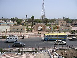
Jardin Public de Rufisque
|
||
Rufisque [ ryˈfisk ] is as Ville de Rufisque a city with over 220,000 inhabitants in the central west of Senegal at the entrance to the Cap-Vert peninsula . It is prefecture of the Rufisque department in the metropolitan region of Dakar and has been divided into the three communes d'arrondissement Rufisque Center (North), Rufisque Est and Rufisque Ouest since 1996 . Under the name Rio Fresco , one of the first Portuguese bases on the West African mainland was established here as a trading port and for supplying their fleet with fresh water. As a port city, France made Rufisque one of the four oldest cities in the country.
Geographical location
Rufisque is a port city on the south coast of the Cap-Vert peninsula , which continues to the southeast in the densely populated and touristic Petite-Côte . The kilometer-wide, very straight stretch of the coastline made of sandy beach jumps back about half a kilometer to the northeast at Rufisque, east of a barrier made of rocky cliffs, and thus forms a protected roadstead , the Rade de Rufisque . At the same time, watercourses flow west of the cliffs, which originally gave rise to the name of the anchorage, but now serve more to drain the urban area.
The metropolitan area of Rufisque is measured to 17.6 square kilometers, is densely built and is bordered to the west by the metropolis of Pikine , on the north by Jaxaay-Parcelles-Niakoul Rap and on the southeast by Bargny . With all these cities, Rufisque has more or less grown together structurally. The capital Dakar is about 19 kilometers to the west on the Cap-Vert Peninsula.
history
Originally the region around the fishing village Tanguegueth or Tenguedj (in the Wolof language Tëngéej ) was settled by the Lébou ethnic group . The village first gained importance when Portugal began in the 15th century to set up trading shops along the coast, later known as the Petite-Côte , for trade with West Africa. These included Joal in the kingdom of Sine in the south , Saly Portudal further north , the former Sali in the Baol kingdom (then called Sali de Portugal or Forte de Portugal ), and in the far north, as the first port of call from the island of Gorée , because of his good water from the seafarers Rio fresco (German roughly fresh water river ) called Tanguegueth in the kingdom of Cayor , which thus became the most important port of this kingdom. The French name Rufisque developed from the Portuguese name .
The Dutch occupied the place in 1617 and built an office that was destroyed in 1677 when Jean II. D'Estrées , Admiral of France , conquered the island of Gorée in the war against the Netherlands. A little later, the Compagnie du Sénégal rebuilt under its director Jean Baptiste du Casse Rufisque as a French trading office. With the Demel of Cayor and the Teigne of Baol , he concluded treaties on trade privileges in favor of France, in which the latter was granted sovereignty over the entire coastal line of these empires. There are no more traces of this first French trading post, not least because France was temporarily ousted from Senegal by England.
Dutch, French and English traders settled here, which soon became a Euro-African ( Creole ) or mestizo society of mixed race children. There was a close exchange of similar communities in Saint-Louis , Gorée and the other ports along the Petite-Côte .
In 1840 a group of businessmen from Saint-Louis, and shortly afterwards from Gorée, built a department store directly on the bank to store peanuts . From 1848 Rufisque belonged to the Quatre Communes in Senegal with full French citizenship. Business flourished and it was possible to expand several times. When the French occupiers built a fort in 1859, Rufisque was unceremoniously attached to the French West Africa colony . Rufisque became an independent municipality in 1862, and in 1885 its port was connected to the Dakar – Niger railway . In 1909 Galandou Diouf († 1941) was elected as a representative from Rufisque to the parliament of the colony in Saint-Louis. He was the first African in this position. The École normal de Rufisque was an important teacher training institution for girls in the city from 1938 to 1958.
In the early 20th century, the neighboring, technically better equipped port of Dakar grew so much that the importance of the port of Rufisque declined considerably. This also reduced industrial activity. Of the four historic parishes, Rufisque has lost the most of its importance. There is no tourism worth mentioning and due to a lack of financial resources, maintenance and expansion of the public infrastructure have been neglected.
population
The last censuses showed the following population figures for the city:
| year | Residents |
|---|---|
| 1976 | 60,403 |
| 1988 | 142,340 |
| 2002 | 143.281 |
| 2013 | 221.066 |
traffic
The traffic axes of the Cap-Vert peninsula , which mediate the west-east traffic between the metropolis of Dakar and the rest of the country, run through Rufisque . This flows through the city on the national road N 1 , on the toll route 1 and on the Dakar – Niger railway line .
Rufisque is connected to the international air transport network via Dakar-Blaise Diagne Airport, which is 23 km away .
The harbor bay and the beach there are berths for a large number of large and small pirogues . The Embarcadère de Rufisque , a pier for larger ships, has been expanded and repaired since 2017 at a cost of 1.3 billion CFA in order to promote the economic development of the city.
economy
Originally a fishing village, Rufisque was developed by the European colonial powers into a flourishing trading post and the main port on the west coast of North Africa. The most important line of business was the trade and processing of peanuts from the peanut basin in the interior. This industry became a source of economic development and prosperity. There was a shipyard, oil mills, and warehouses. The expansion of Dakar to the main port resulted in the migration of many factories and companies.
Nonetheless, apart from the important fish market at the port, Rufisque is still an important industrial location. On the eastern outskirts, between Rufisque and Bargny, is Sococim , the only cement works in the country with its quarries. From there, all of Senegal is supplied with the factory's products by truck.
The Cap des Biches power plant park is located in Rufisque Ouest , with a capacity of over 340 MW installed in several power plant blocks . This means that around a third of the energy consumed across the country via Senelec's network can be generated.
Town twinning
-
 Nantes , France
 -
 Rio de Janeiro , Brazil
Personalities
- Mamadou Seyni Mbengue (1925–2010), Senegalese journalist, playwright and diplomat
- Badara Mamaya Sène (1945–2020), Senegalese football referee and mayor of Rufisque
- Alioune Sall (* 1962), Senegalese lawyer and former judge at the ECOWAS Court of Justice
- Guirane N'Daw (* 1984), Senegalese football player
- Cheikh N'Doye (* 1986), Senegalese football player
- Adama Mbengue (* 1993), Senegalese football player
See also
Web links
- City of Rufisque on the Internet
- Rufisque at Planete Senegal
- au-senegal.com of August 24, 2007: Rufisque
- FallingRain Map - elevation = 1m
- Rufisque at Geonames
Individual evidence
- ↑ Boundary course of the city districts in map and satellite photo ( Memento from January 6, 2020 in the Internet Archive )
- ^ Rade de Rufisque at Geonames
- ↑ Area information on the urban area at ANSD: Situation économique et sociale de la Région de Dakar 2004 Page 167 of the PDF file 1.12 MB
- ↑ P.-David Boilat, Paris 1853: Esquisses sénégalaises , p. 55 Notice sur Tanguegueth ou Rufisque in the Google book search
- ↑ Mention of the factories in the entry on Forte de Portudal under Cronologia in the Portuguese list of monuments SIPA, accessed on June 30, 2018
- ↑ Pascale Barthélémy: Instruction ou éducation? La formation des Africaines à l'École normal d'institutrices de l'AOF de 1938 à 1958 . In: Cahiers d'Études africaines . No. 169–170 , 2003, pp. 371–388 ( journals.openedition.org [accessed December 26, 2017]).
- ↑ City Population - the population of the most important cities in Senegal
- ↑ Measure distance with google maps
- ↑ Seneweb of May 21, 2017: Embarcadère de Rufisque. Les travaux de rehabilitation lancés ce samedi
- ↑ History of SOCOCIM INDUSTRIES
- ↑ Senelec: Power Plant Park 2017


