Guinaw Rail North
| Guinaw Rail Nord Commune d'arrondissement Guinaw Rail Nord |
|
|---|---|
| Coordinates | 14 ° 45 '3 " N , 17 ° 22' 58" W |
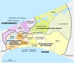
 The 16 communes d'arrondissement in Pikine The 16 communes d'arrondissement in Pikine
|
|
| Basic data | |
| Country | Senegal |
| Dakar | |
| Department | Pikins |
| ISO 3166-2 | SN-DK |
| Arrondissement | Arrondissement de Pikine Dagoudane |
| height | 9 m |
| surface | 0.7 km² |
| Residents | 30,058 (2013) |
| density | 42,940 Ew. / km² |
Guinaw Rail Nord is one of the 16 districts (Communes d'arrondissement du Sénégal) of Pikine , the largest city in Senegal before the capital Dakar . The expression "Guinaw Rail" comes from the Wolof language, which is widespread in Senegal, and means "behind the rails" and thus describes the districts that were created without urban planning through wild growth on the southern edge of Alt-Pikine on the other side of the Dakar-Niger railway line . As of 2013, the city district was part of the Restructuration de Pikine Irrégulier Sud (PIS) , a 700 hectare district redevelopment that affects 220,000 residents as part of the motorway project L'autoroute à péage Dakar – Diamniadio for the construction of Autoroute 1 .
geography
Guinaw Rail Nord is located in the center of the bottleneck of the Cap-Vert peninsula between the Dakar – Niger railway line in the north and Autoroute 1 in the south.
The city district, which is almost an equilateral triangle, has an area of 0.7 km² with a side length of around 1200 meters each. It is completely built up and very densely populated. From 2012 onwards, it was the scene of extensive renovation measures and clearing of the deeper-lying areas exposed to the risk of flooding, which met with some fierce resistance from the affected population.
The Route des Niayes forms the demarcation from the northeastern neighboring district of Thiaroye Gare . Across the railway line to the northwest is the Pikine Est borough . In the southwest, the development merges into the Guinaw Rail Sud district .
population
The last censuses showed the following population figures for the city district:
| year | Residents |
|---|---|
| 1988 | ... |
| 2002 | 30 142 |
| 2013 | 30 058 |
Individual evidence
- ↑ Un film de Kady Diedhiou 2014: Guinaw Rails (Derrière les Rails) Behind The Rails
- ↑ Association Waranka GR. Valoriser et Améliorer les Ressources et l'Environnement des Quartiers de Guinaw Rail
- ^ Projet de l'autoroute à péage Dakar-Diamniadio. Restructuration de Pikine Irrégulier Sud. Rapport etude d'Impact Environnemental et social, February 2013 , PDF file 6.67 MB
- ^ City districts of Pikine in Monographie de Dakar 2014 page 5 of the PDF file 4.4 MB
- ↑ Guinaw Rail Nord on Google Maps
- ↑ Estimation of the population of Dakar par collectivité locale en 2004 Area of the city districts on page 166 of the PDF file 1.12 MB
- ↑ Sene News, August 24, 2012: Inondations / Déguerpissement: Les habitants de Guinaw rail nord refusent de quitter leurs domiciles. report
- ↑ ANSD: Résultats préliminaires du Troisième Recensement Général de la Population et de l'Habitat du Sénégal de 2002 (RGPH-III) ( Memento of September 28, 2007 in the Internet Archive ) City districts of Pikine with statistics on their population Page 9 of the PDF File 1.64 MB
- ↑ ANSD: Rapport Projection de la Population du Senegal 2013–2063 (RGPHAE 2013) Figures for 2013, pages 21–22 of the PDF file 1.44 MB