Thiaroye sur Mer
| Thiaroye sur Mer Commune d'arrondissement Thiaroye sur Mer |
|
|---|---|
| Coordinates | 14 ° 44 '34 " N , 17 ° 22' 52" W |
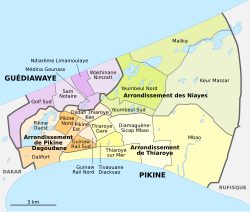
 The 16 communes d'arrondissement in Pikine The 16 communes d'arrondissement in Pikine
|
|
| Basic data | |
| Country | Senegal |
| Dakar | |
| Department | Pikins |
| ISO 3166-2 | SN-DK |
| Arrondissement | Arrondissement de Thiaroye |
| height | 14 m |
| surface | 3.5 km² |
| Residents | 52,773 (2013) |
| density | 15,078 Ew. / km² |
Thiaroye sur Mer is one of the 16 districts (Communes d'arrondissement du Sénégal) of Pikine , the largest city in Senegal even before the capital Dakar .
geography
Thiaroye sur Mer is located in the south of the bottleneck of the Cap-Vert peninsula on the Baie de Hann . The northern border of the district follows the course of the national road N 1 . To the north are the districts of Pikine Ouest , Guinaw Rail Sud , Tivaouane Diacksao and Diamaguène-Sicap Mbao . The latter also forms the eastern border with the refinery site of the Société africaine de raffinage (SAR) . Thiaroye sur Mer shares a contiguous industrial area with the Dalifort district to the west . The east-west extension of the district is around 5500 meters, the south-north extension varies between 500 and 1000 meters.
The municipality has an area of 3.5 km². and, with the exception of a few vacant lots and garden areas in the eastern half, is almost completely built on.
history
Thiaroye sur Mer, together with Hann , Mbao and Rufisque, is one of the old fishing settlements on the south bank of the Cap-Vert peninsula and is traditionally known as such as Mbatal .
population
The last censuses showed the following population figures for the city district:
| year | Residents |
|---|---|
| 1988 | ... |
| 2002 | 36 602 |
| 2013 | 52 773 |
Individual evidence
- ↑ Baie de Hann at Geonames
- ↑ Measure distances with google maps
- ↑ Estimation of the population of Dakar par collectivité locale en 2004 Area of the city districts on page 166 of the PDF file 1.12 MB
- ↑ Historique du développement spatial de Dakar in Monographie de Dakar 2014 Thiaroye sur Mer and other old places as a black area on the map on page 14 of the PDF file 4.4 MB
- ↑ ANSD: Résultats préliminaires du Troisième Recensement Général de la Population et de l'Habitat du Sénégal de 2002 (RGPH-III) ( Memento of September 28, 2007 in the Internet Archive ) City districts of Pikine with statistics on their population Page 9 of the PDF File 1.64 MB
- ↑ ANSD: Rapport Projection de la Population du Senegal 2013–2063 (RGPHAE 2013) Figures for 2013, pages 21–22 of the PDF file 1.44 MB