Yeumbeul Sud
| Yeumbeul Sud Commune d'arrondissement Yeumbeul Sud |
|
|---|---|
| Coordinates | 14 ° 46 '1 " N , 17 ° 22' 4" W |
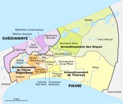
 The 16 communes d'arrondissement in Pikine The 16 communes d'arrondissement in Pikine
|
|
| Basic data | |
| Country | Senegal |
| Dakar | |
| Department | Pikins |
| ISO 3166-2 | SN-DK |
| Arrondissement | Arrondissement des Niayes |
| height | 24 m |
| surface | 1.1 km² |
| Residents | 96,956 (2013) |
| density | 88,141.8 Ew. / km² |
Yeumbeul Sud is one of the 16 districts (Communes d'arrondissement du Sénégal) of Pikine , the largest city in Senegal even before the capital Dakar .
geography
Yeumbeul Sud is long, narrow and irregularly delimited in the northern center of the bottle neck of the Cap-Vert peninsula . The municipality extends in a west-east direction three and a half kilometers with a width of 300 to 1000 meters on a section of the Route de Malika between the groundwater-endangered basin Marché Bou Bess in the west (inclusive) to the old village Boune (exclusive) in the East. This old village is at the end of the Route de Boune , which in turn forms the northern boundary of the borough. The southern border follows the course of the Dakar – Niger railway . With the exception of a few scattered flood-prone depressions, after all, Yeumbeul Sud is located in the wetlands of the Niayes , the municipality is almost completely built up and extremely densely populated.
The municipality has an area of 1.1 km². Neighboring clockwise are the districts of Yeumbeul North in the north, Keur Massar in the east, Diamaguène-Sicap Mbao in the south, Thiaroye Gare and Djidah Thiaroye Kao in the southwest and in the northwest the districts of Médina Gounass and Wakhinane Nimzatt of the neighboring town of Guédiawaye .
population
The last censuses showed the following population figures for the city district:
| year | Residents |
|---|---|
| 1988 | ... |
| 2002 | 80 439 |
| 2013 | 96 956 |
traffic
Yeumbeul Sud is north of the traffic axes of the Cap-Vert Peninsula, on which the west-east traffic flows between the metropolis of Dakar and the rest of the country. This traffic is served by the national road N 1 , as well as the Dakar – Niger railway line and the toll road 1 .
In Yeumbeul Sud itself, the Route de Malika serves as the main traffic axis . It comes from the southwest from Gare de Thiaroye and continues through Yeumbeul North to Malika in the northeast. With junction 7 of Autoroute 1 , the district has a fast connection to the west with the capital Dakar via Route de Malika and in east direction Route de Boune connects it via junction 8 with the new international airport Dakar-Blaise Diagne .
Individual evidence
- ↑ Boune at Geonames
- ↑ Estimation of the population of Dakar par collectivité locale en 2004 Area of the city districts on page 166 of the PDF file 1.12 MB
- ↑ ANSD: Résultats préliminaires du Troisième Recensement Général de la Population et de l'Habitat du Sénégal de 2002 (RGPH-III) ( Memento of September 28, 2007 in the Internet Archive ) City districts of Pikine with statistics on their population Page 9 of the PDF File 1.64 MB
- ↑ ANSD: Rapport Projection de la Population du Senegal 2013–2063 (RGPHAE 2013) Figures for 2013, pages 21–22 of the PDF file 1.44 MB