Mbao
| Mbao Commune d'arrondissement Mbao |
|
|---|---|
| Coordinates | 14 ° 44 ′ 20 ″ N , 17 ° 18 ′ 39 ″ W |
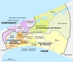
 The 16 communes d'arrondissement in Pikine The 16 communes d'arrondissement in Pikine
|
|
| Basic data | |
| Country | Senegal |
| Dakar | |
| Department | Pikins |
| ISO 3166-2 | SN-DK |
| Arrondissement | Arrondissement de Thiaroye |
| height | 4 m |
| surface | 17.4 km² |
| Residents | 96,320 (2013) |
| density | 5,535.6 Ew. / km² |
Mbao is one of the 16 districts (Communes d'arrondissement du Sénégal) of Pikine , the largest city in Senegal before the capital Dakar .
geography
Mbao is located in the southeast of the bottleneck of the Cap-Vert Peninsula . The north of the borough is occupied by the Forêt classée de Mbao (FCM) cut through by Autoroute 1 and threatened by the surrounding urbanization . The residential areas on both sides of the N 1 national road and the Dakar – Niger railway line stretch between this still largest green lung in the Dakar metropolitan region and the Baie de Hann in the south . The municipality has an area of 17.4 km². The borderline results from a satellite photo released in 2019 as part of an official documentation.
On both sides of the coastal section of Mbao, beyond the district boundary, there are two purely industrial areas, in the west the Zone Industrielle de Mbao with extensive refineries and in the east Cap des Biches with the Senelec power plant park . Neighboring boroughs are Diamaguène-Sicap Mbao in the west, Keur Massar in the north and the Rufisque Ouest borough of the neighboring town Rufisque in the east.
population
The last censuses showed the following population figures for the city district:
| year | Residents |
|---|---|
| 1988 | ... |
| 2002 | 26 011 |
| 2013 | 96 320 |
traffic
Junction 8 of Autoroute 1 in the Forêt de Mbao connects the city district to the west with the capital Dakar and to the east with the new international airport Dakar-Blaise Diagne .
Individual evidence
- ↑ enqueteplus of February 11, 2016: Forêt classée de Mbao. Quand la végétation fait des heureux
- ↑ Baie de Hann at Geonames
- ↑ Estimation of the population of Dakar par collectivité locale en 2004 Area of the city districts on page 166 of the PDF file 1.12 MB
- ^ Agence nationale de l'Aménagement du Territoire (ANAT), December 20, 2019: Missions de démarcation de communes. Jaxaay-Parcelles Assainies-Niakoul Rab / Mbao / Keur Massar / Rufisque Ouest / Tivaouane Peul-Niaga
- ^ Boundary course in the satellite photo ( Memento from January 6, 2020 in the Internet Archive )
- ^ City districts of Pikine in Monographie de Dakar 2014 page 5 of the PDF file 4.4 MB
- ↑ ANSD: Résultats préliminaires du Troisième Recensement Général de la Population et de l'Habitat du Sénégal de 2002 (RGPH-III) ( Memento of September 28, 2007 in the Internet Archive ) City districts of Pikine with statistics on their population Page 9 of the PDF File 1.64 MB
- ↑ ANSD: Rapport Projection de la Population du Senegal 2013–2063 (RGPHAE 2013) Figures for 2013, pages 21–22 of the PDF file 1.44 MB