Djidah Thiaroye Kao
| Djidah Thiaroye Kao Commune d'arrondissement Djidah Thiaroye Kao |
|
|---|---|
| Coordinates | 14 ° 46 '11 " N , 17 ° 22' 47" W |
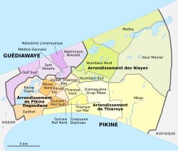
 The 16 communes d'arrondissement in Pikine The 16 communes d'arrondissement in Pikine
|
|
| Basic data | |
| Country | Senegal |
| Dakar | |
| Department | Pikins |
| ISO 3166-2 | SN-DK |
| Arrondissement | Arrondissement de Pikine Dagoudane |
| height | 15 m |
| surface | 1.9 km² |
| Residents | 96,952 (2013) |
| density | 51,027.4 Ew. / km² |
Djidah Thiaroye Kao is one of the 16 districts (Communes d'arrondissement du Sénégal) of Pikine , the largest city in Senegal before the capital Dakar .
geography
Djidah Thiaroye Kao is long, narrow and irregularly delimited in the northern center of the bottle neck of the Cap-Vert peninsula between the neighboring town of Guédiawaye in the north and the Route des Niayes in the southwest and the Route de Malika in the southeast.
The city district, whose west-east extension is around 3100 meters, has an area of 1.9 km². With the exception of an elongated five-hectare water-bearing depression in the center, which divides it into two halves, the city district is completely built up and extremely densely populated. It is bounded in the southwest by the districts of Pikine Nord and Pikine Est , in the southeast by Thiaroye Gare , in the east by Yeumbeul Sud and in the north by the districts of Sam Notaire and Médina Gounass of the neighboring town of Guédiawaye, with Djidah Thiaroye Kao the latter projecting southwards Médina Gounass encloses on three sides.
With the exception of the district in the far west, the greater part of Djidah Thiaroye Kao was built before 1966 as Pikine irregulier , as a haphazard expansion of the planned urban planning satellite town of Pikine to the east. The lack of plan can be recognized by the fact that the regular checkerboard pattern of the street network of Alt-Pikine becomes irregular. At that time, sinks were also built in the east of the city district, which became uninhabitable after the end of the drought from 2005 due to rising groundwater and floods. As of 2019, the satellite perspective shows ruined houses partially overgrown by green. The areas that have become recognizably uninhabitable are around ten hectares.
population
The last censuses showed the following population figures for the city district:
| year | Residents |
|---|---|
| 1988 | ... |
| 2002 | 90 586 |
| 2013 | 96 952 |
traffic
The Route des Niayes connects the district south of Thiaroye Gare with junction 7 of Autoroute 1 1200 meters away and from there to the west with the capital Dakar and to the east with the new Dakar-Blaise Diagne airport . The Gare de Thiaroye station on the Dakar – Niger line is located in the south-east, just 200 meters outside the borough's border.
Individual evidence
- ^ City districts of Pikine in Monographie de Dakar 2014 page 5 of the PDF file 4.4 MB
- ↑ Estimation of the population of Dakar par collectivité locale en 2004 Area of the city districts on page 166 of the PDF file 1.12 MB
- ↑ Jenny Axelsson & Martin Linge, Lund 2012: Why do people live in Guinaw Rails South? - a study of why people live in a high-risk community , Pikine irregulier 1966/67 on page 24 of the PDF file 2.03 MB
- ↑ Measure areas with google maps
- ↑ ANSD: Résultats préliminaires du Troisième Recensement Général de la Population et de l'Habitat du Sénégal de 2002 (RGPH-III) ( Memento of September 28, 2007 in the Internet Archive ) City districts of Pikine with statistics on their population Page 9 of the PDF File 1.64 MB
- ↑ ANSD: Rapport Projection de la Population du Senegal 2013–2063 (RGPHAE 2013) Figures for 2013, pages 21–22 of the PDF file 1.44 MB