Tivaouane Diacksao
| Tivaouane Diacksao Commune d'arrondissement Tivaouane Diacksao |
|
|---|---|
| Coordinates | 14 ° 44 '49 " N , 17 ° 21' 44" W |
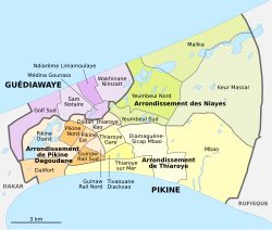
 The 16 communes d'arrondissement in Pikine The 16 communes d'arrondissement in Pikine
|
|
| Basic data | |
| Country | Senegal |
| Dakar | |
| Department | Pikins |
| ISO 3166-2 | SN-DK |
| Arrondissement | Arrondissement de Thiaroye |
| height | 15 m |
| surface | 1.1 km² |
| Residents | 40,561 (2013) |
| density | 36,873.6 Ew. / km² |
Tivaouane Diacksao is one of the 16 districts (Communes d'arrondissement du Sénégal) of Pikine , the largest city in Senegal even before the capital Dakar . As of 2013, the city district was part of the Restructuration de Pikine Irrégulier Sud (PIS) , a 700 hectare district redevelopment that affects 220,000 residents as part of the motorway project L'autoroute à péage Dakar – Diamniadio for the construction of Autoroute 1 . The renovation work in the busy district of Poste Thiaroye was largely completed by the end of 2017. This was preceded by extensive evictions of occupied land, some of which had been used and built on for decades without legal title.
geography
Tivaouane Diacksao lies in the center of the bottleneck of the Cap-Vert peninsula like a wedge between the districts of Thiaroye sur Mer in the south and Thiaroye Gare in the north.
The approximately trapezoidal boundaries of the city district has an area of 1.1 km². It is almost completely built up and densely populated.
The southern border of the district follows the course of the national road N 1 . To the south of this is the district of Thiaroye sur Mer . The Route des Niayes forms the border with the neighboring district to the west of Guinaw Rail Sud and in the north lies the district of Thiaroye Gare beyond Autoroute 1 .
population
The last censuses showed the following population figures for the city district:
| year | Residents |
|---|---|
| 1988 | ... |
| 2002 | 30 728 |
| 2013 | 40 561 |
traffic
Junction 7 of Autoroute 1 in the west of Tivaouane Diacksao connects the city district to the west with the capital Dakar and to the east, after passing a toll on the main carriageway, with the new Dakar-Blaise Diagne airport .
Individual evidence
- ^ Projet de l'autoroute à péage Dakar-Diamniadio. Restructuration de Pikine Irrégulier Sud. Rapport etude d'Impact Environnemental et social, February 2013 , PDF file 6.67 MB
- ↑ Le Quotidien, December 9, 2017: Déguerpissements dans la banlieue: Pikine et Poste Thiaroye respirent
- ^ City districts of Pikine in Monographie de Dakar 2014 page 5 of the PDF file 4.4 MB
- ↑ Estimation of the population of Dakar par collectivité locale en 2004 Area of the city districts on page 166 of the PDF file 1.12 MB
- ↑ ANSD: Résultats préliminaires du Troisième Recensement Général de la Population et de l'Habitat du Sénégal de 2002 (RGPH-III) ( Memento of September 28, 2007 in the Internet Archive ) City districts of Pikine with statistics on their population Page 9 of the PDF File 1.64 MB
- ↑ ANSD: Rapport Projection de la Population du Senegal 2013–2063 (RGPHAE 2013) Figures for 2013, pages 21–22 of the PDF file 1.44 MB