Pilica (river)
|
Pilica Pilitza |
||
|
The Pilica near Tomaszów Mazowiecki |
||
| Data | ||
| location | Poland | |
| River system | Vistula | |
| Drain over | Vistula → Baltic Sea | |
| source | in the Krakow-Czestochowa Jura southwest of Pilica 50 ° 27 ′ 11 ″ N , 19 ° 38 ′ 29 ″ E |
|
| Source height | 350 m | |
| muzzle | near Ostrówek (municipality of Warka ) in the Vistula Coordinates: 51 ° 51 ′ 42 ″ N , 21 ° 16 ′ 50 ″ E 51 ° 51 ′ 42 ″ N , 21 ° 16 ′ 50 ″ E
|
|
| length | 319 km | |
| Catchment area | 8341 km² | |
| Drain |
MQ |
48.6 m³ / s |
| Left tributaries | Rykolanka , Mogielanka , Rokitna , Gać , Wolbórka , Luciąża , Białka , Krztynia | |
| Right tributaries | Dyga , Pierzchnianka , Drzewiczka , Słomianka , Czarna Konecka , Czarna Włoszczowska , Zlewcza | |
| Medium-sized cities | Tomaszów Mazowiecki | |
| Small towns | Białobrzegi , Warka | |
| Communities | Koniecpol , Przedbórz , Sulejów , Nowe Miasto nad Pilicą , Wyśmierzyce | |
|
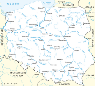
Location of the Pilica in the system of Polish rivers |
||
The Pilica [ piˈlit͡sa ] ( German Pilitza ) is a central Polish left tributary of the Vistula . It rises in the Kraków-Czestochowa Jura one kilometer southwest of the city of Pilica and flows through the cities of Koniecpol , Przedbórz , Sulejów , Tomaszów Mazowiecki , Nowe Miasto nad Pilicą , Wyśmierzyce , Białobrzegi and Warka for a total length of 319 km , where it joins the Vistula. The mean discharge in Białobrzegi is 48.6 m³ / s.
literature
- Rymut, Kazimierz: names of waters in the left tributary area of the Vistula between Przemsza and Pilica, Stuttgart: Steiner, 2001
- Duma, Jerzy: names of waters in the left tributary area of the Vistula between Pilica and Brda, Stuttgart: Steiner, 1999
Individual evidence
Web links
Commons : Pilica - collection of images, videos and audio files

