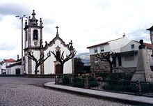
Pinhanços
| Pinhanços | ||||||
|---|---|---|---|---|---|---|
|
||||||
| Basic data | ||||||
| Region : | Centro | |||||
| Sub-region : | Beiras e Serra da Estrela | |||||
| District : | Guarda | |||||
| Concelho : | Seia | |||||
| Coordinates : | 40 ° 28 ′ N , 7 ° 41 ′ W | |||||
| Residents: | 716 (as of June 30, 2011) | |||||
| Surface: | 8.33 km² (as of January 1, 2010) | |||||
| Population density : | 86 inhabitants per km² | |||||
| Postal code : | 6270-141 | |||||
| politics | ||||||
| Mayor : | Sónia Prazeres Marques de Oliveira Martins | |||||
| Address of the municipal administration: | Junta de Freguesia de Pinhanços Largo Dr. Carlos Alves, nº 22 6270-141 Pinhanços |
|||||
Pinhanços is a town and municipality in Portugal . With the Aerodromo de Seia the airfield is Seia in the community. It is used for sport aircraft, but mainly as a base for fire brigade planes for reconnaissance and fire fighting in the surrounding Serra da Estrela .
history
Finds prove the origin of the place during the time of the Arab rule. After the Christian Reconquista , the village belonged to the Seia municipality until the 16th century, and only then became independent.
administration
Pinhanços is a parish ( freguesia ) in the district ( concelho ) of Seia , in the Guarda district . 716 inhabitants (as of June 30, 2011) live in it on an area of 8.3 km².
Web links
- Information on the municipality of Pinhanços on the Seia County Council website
- Photos from Pinhanços on Flickr
Individual evidence
- ↑ a b www.ine.pt - indicator resident population by place of residence and sex; Decennial in the database of the Instituto Nacional de Estatística
- ↑ Overview of code assignments from Freguesias on epp.eurostat.ec.europa.eu
- ↑ Brief portrait of the municipality of Pinhanços on the website of the Seia district administration, accessed on March 8, 2015
- ↑ Entry of the parish church of Pinhanços in the Portuguese list of monuments SIPA (see under Cronologia ), accessed on March 8, 2015


