
Piz Nair (Albula)
| Piz Nair | ||
|---|---|---|
 Piz Nair, on the left the mountain station of the cable car ( 3030 m ) |
||
| height | 3055 m above sea level M. | |
| location | Canton of Graubünden , Switzerland | |
| Mountains | Albula Alps | |
| Dominance | 1.2 km → Piz Grisch | |
| Notch height | 184 m ↓ Fuorcla Schlattain | |
| Coordinates | 780 247 / 153258 | |
|
||

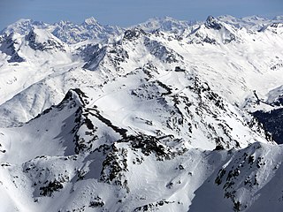
The Piz Nair ( nair comes from the Latin niger and stands for 'black' in Rhaeto-Romanic and is pronounced as “Piz När” in Puter ) is 3055 m above sea level. M. high mountain in the canton of Graubünden ( Switzerland ). The summit is often referred to as the local mountain of St. Moritz ( 1822 m ) and is a popular panoramic mountain . It is accessible by a cable car during both the winter and summer seasons .
Location and surroundings

Piz Nair is a good starting point for the surrounding crossings and peaks and offers a beautiful view of the Engadine lake landscape. The municipal boundaries of St. Moritz and Celerina meet at the summit .
The Piz Nair belongs to the Piz Ot group and is part of the Albula Alps . The area is developed through a dense network of hiking trails. The region offers climbers and mountain hikers a lot of geological variety: On the one hand, the hard and fissured granite rocks of the bizarre rocks of Piz Corviglia ( 3059 m ), Piz Saluver ( 3160 m ) and Piz Ot ( 3247 m ); on the other hand the light, fragile dolomites and limestone of Piz Padella ( 2855 m ) and the Trais Fluors; and finally the crumbling pyramid of Piz Nair. The Piz Nair and its eastern pre-summit are built from the youngest rock in the area, the colorful “Saluver Breccia”.
Its neighboring peaks include the Piz Ot ( 3247 m ), the Piz Saluver ( 3160 m ), the Piz Corviglia ( 3059 m ), the Piz Grisch ( 3098 m ), the Piz Bever ( 3229 m ), the Piz Suvretta ( 3143 m) ), the Corn Suvretta ( 3071 m ), the Piz Julier ( 3380 m ) and the Piz Albana ( 3098 m ). The mountain lakes Lej Suvretta ( 2602 m ), Lej da la Pêsch ( 2750 m ) and Lej Alv ( 2532 m ) are in the immediate vicinity of Piz Nair . In the north-west and south-west, the Piz Nair is bordered by two Alps, the Suvretta da Samedan and the Suvretta da San Murezzan. In between lies the Suvretta pass ( 2613 m ). The valley basin between Piz Nair and Piz Suvretta is a convenient transition from St. Moritz / Champfèr ( 1825 m ) to Val Bever.
The farthest visible point from Piz Nair is the Matterhorn ( 4478 m ) in the Valais Alps . It is 174 km to the west.
Development

The Piz Nair is at 3030 m above sea level. M. the highest mountain station in the Corviglia ski area . After Piz Corvatsch ( 3451 m ) it is the second highest developed mountain in the Engadine. A funicular takes you from St. Moritz via Chantarella to Corviglia ( 2,488 m ). Corviglia can be reached from Celerina by cable car and chairlift . During the winter and summer seasons, a cable car leads from Corviglia to Piz Nair, which has been accessible since 1955. The current 100-LPB system from the manufacturer Garaventa has been in operation since 2002. There is a panorama restaurant connected to the mountain station, which is open both in winter and in summer.
Alpine ski racing
So far, there have been two Olympic Winter Games in Switzerland : 1928 and 1948 , both in St. Moritz. On the occasion of the 1948 staging, the alpine ski competitions were held in the Corviglia ski area, the men's downhill run started on Piz Nair at an altitude of 2700 m above sea level. M.
St. Moritz has already hosted an Alpine World Ski Championships five times . For the 2003 World Ski Championships , the former Swiss ski racer and today's piste builder Bernhard Russi designed the Corviglia piste. The men's speed disciplines were held on this route. The start took place east of Piz Nair immediately below Piz Nair Pitschen ( 2876 m ) at 2840 m above sea level. M. The 150 m long start slope has a gradient of 45 degrees and is considered the longest and steilster starting section in ski racing. The drivers accelerate from 0 to 140 km / h within six seconds.
Routes to the summit
Summer routes
From St. Moritz
- Starting point: St. Moritz ( 1822 m )
- Via: Alp Giop, Corviglia ( 1825 m ), Munt da San Murezzan ( 2686 m )
- Time required: 3 hours
- Note: Up to the mountain station below the peak as a trail white-red-white highlighted
- Alternative: from Alp Giop ( 2263 m ) directly to Munt da San Murezzan ( 2686 m )
From the Suvretta pass
- Starting point: St. Moritz ( 1822 m ), Champfèr ( 1825 m ), Spinas ( 1815 m ), Chamanna Jenatsch ( 2653 m ) or Silvaplana ( 1815 m )
- Via: Pass Suvretta ( 2613 m )
- Time required: 4 hours from Champfèr or Chamanna Jenatsch, 4½ hours from St. Moritz, 4¾ hours from Spinas, 5 hours from Silvaplana
- Note: Up to the mountain station below the peak as a trail white-red-white highlighted
- Alternative: from Pass Suvretta over Fuorcla Schlattain ( 2872 m ) to the summit
About the Fuorcla Schlattain
- Starting point: St. Moritz ( 1822 m ), Champfèr ( 1825 m ), Spinas ( 1815 m ), Chamanna Jenatsch ( 2653 m ), Silvaplana ( 1815 m ) or Celerina ( 1730 m )
- Via: Fuorcla Schlattain ( 2872 m )
- Time required: 4 hours from Champfèr, St. Moritz or the Chamanna Jenatsch, 4¾ hours from Spinas, 4¾ hours from Celerina, 5 hours from Silvaplana
- Note: Up to the mountain station below the peak as a trail white-red-white highlighted
panorama

gallery

View of St. Moritz, Lake St. Moritz and the Corviglia ski area (Piz Nair on the left) from Muottas da Schlarigna

The Ibex Guardiaun Grischun right at the Piz Nair mountain station
Piz Nair mountain station, taken from Piz Surgonda

Valley station of the Corviglia-Piz Nair cable car


Web links
- Calculated 360 ° panorama from Piz Nair
- Website of the Corviglia Piz Nair Marguns ski area
- Website of the Ski World Cup St. Moritz
literature
- Eugen Wenzel, Paul Gross: club guide, Bündner Alps . Albula. 2nd Edition. tape VI . Verlag des SAC, 1980, ISBN 3-85902-012-9 , p. 16-17 .
- Eugen Wenzel, Paul Gross: club guide, Bündner Alps . Albula. 2nd Edition. tape VI . Verlag des SAC, 1980, ISBN 3-85902-012-9 , p. 54-55 .
- National map of Switzerland, sheet 1257 St. Moritz, 1: 25,000, Federal Office of Topography, 2015 edition.
source
- ↑ a b Height according to SwissTopo (maps of Switzerland)
- ↑ Andrea Schorta: How the mountain got its name . Small Rhaetian name book with two and a half thousand geographical names of Graubünden. Terra Grischuna Verlag, Chur and Bottmingen / Basel 1988, ISBN 3-7298-1047-2 , p. 108 .
- ↑ Eugen Wenzel, Paul Gross: Club Guide, Bündner Alpen . Albula. 2nd Edition. tape VI . Verlag des SAC, 1980, ISBN 3-85902-012-9 , p. 54-55 .
- ↑ Eugen Wenzel, Paul Gross: Club Guide, Bündner Alpen . Albula. 2nd Edition. tape VI . Verlag des SAC, 1980, ISBN 3-85902-012-9 , p. 16-17 .
- ↑ Calculated 360 ° panorama ( U. Deuschle ; information ) from Piz Nair
- ↑ mountains.ch website Engadin St. Moritz Mountains. Retrieved April 24, 2020.
- ↑ bergbahnen.org cable cars in Germany and Switzerland. Retrieved April 27, 2020.
- ↑ https://www.skiweltcup-stmoritz.ch/ . Retrieved April 24, 2020.