Podkumok
|
Podkumok Подку́мок |
||
|
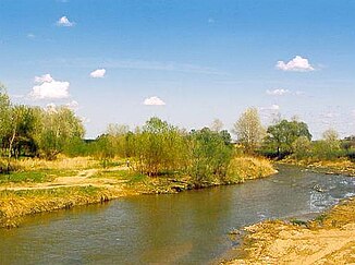
The Podkumok near the mouth near Georgievsk |
||
| Data | ||
| Water code | RU : 07010000412108200001753 | |
| location | Karachay-Cherkessia , Stavropol Region ( Russia ) | |
| River system | Kuma | |
| Drain over | Kuma → Caspian Sea | |
| source | Skalisty ridge of the Greater Caucasus east of Karachayevsk 43 ° 45 ′ 52 ″ N , 42 ° 13 ′ 44 ″ E |
|
| Source height | approx. 2000 m | |
| muzzle | at Georgievsk in the Kuma coordinates: 44 ° 12 ′ 11 ″ N , 43 ° 29 ′ 29 ″ E 44 ° 12 ′ 11 ″ N , 43 ° 29 ′ 29 ″ E |
|
| Mouth height | approx. 235 m | |
| Height difference | approx. 1765 m | |
| Bottom slope | approx. 11 ‰ | |
| length | 160 km | |
| Catchment area | 2220 km² | |
| Drain |
MQ |
8 m³ / s |
| Big cities | Kislovodsk , Pyatigorsk | |
| Medium-sized cities | Essentuki , Goryachevodsky , Georgievsk | |
| Small towns | Swobody | |
| Communities | Uchkeken , Essentukskaya , Neslobnaja | |
| Navigable | not navigable | |
Podkumok ( Russian Подку́мок ) is a mountain river in the Caucasus in southern Russia . It is the largest right tributary of the Kuma .
General
The Podkumok rises in the mountains of Karachay-Circassia near the well 2000 meters high Gumbaschi -Pass about 25 km east of the city Karachayevsk . It flows mainly in a north-easterly direction and after a good third of its length of around 160 kilometers below the village of Utschkeken, it reaches the Stavropol region . There he crosses the cities of Kislovodsk , Essentuki , Pyatigorsk and Georgievsk . Due to the relatively high number of places on the Podkumok, the river is considered to be ecologically polluted. Trout and other fish can be caught in the relatively clean upper reaches of the river . The catchment area of Podkumok is around 2220 km². The scenic location of the Podkumok fascinated the poet Mikhail Lermontow , among others , in whose works the river and the surrounding region are mentioned several times.
Infrastructure and use
Russia's first hydropower plant was built on Podkumok near Essentuki in 1903 . The A157 highway from Karachayevsk runs through the entire valley of the river from its source to Pyatigorsk, mostly on the left bank . The M29 crosses the river in Pyatigorsk ; From there the regional road R264 leads to Georgievsk, which is located near the mouth, where it crosses it at Stanitsa Lyssogorskaya.
