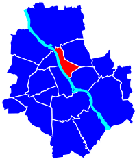
Praga-Północ
|
Praga-Północ district of Warsaw |
|
|---|---|
| Coordinates | 52 ° 15 '48 " N , 21 ° 1' 42" E |
| surface | 11.42 km² |
| Residents | 68,699 (Dec 2012) |
| Population density | 6016 inhabitants / km² |
| Website | http://www.praga-pn.waw.pl |
| politics | |
| mayor | Ilona Soy Kozłowska |
Praga-Północ (German Praga-Nord ) is a central district of Warsaw east of the Vistula .
Since the district was far less destroyed in the Second World War than the districts west of the Vistula, it has retained its historical character. Most of the fabric of residential and industrial buildings dates from the late 19th century, the early 20th century and the interwar period. In the 1950s and 1960s, however, large housing estates with socialist-realistic architecture were built here ( Praga I , Praga II , Praga III ). The historical buildings were neglected for decades, they were in need of renovation after the fall of the Wall . Accordingly, the city district in Warsaw was not very popular and was considered unsafe. The district has been gaining popularity since the 2010s. Galleries, artists and modern gastronomy settle in historic tenement houses and abandoned factories. The often controversial privatization of urban properties led to house renovations and the beginning of gentrification .
history
The Warsaw suburb of Praga , which was originally granted city rights , has been part of the urban area since the end of the 18th century and is therefore one of the oldest parts of the city. In 1945 Praga was divided into the districts of Praga-Północ and Praga-Południe . Praga-Północ has been one of Warsaw's 18 districts since 2002 and today consists of the four districts Pelcowizna, Nowa Praga, Stara Praga and Szmulowizna.

Infrastructure
Praga-Północ is connected to the districts of Śródmieście and Żoliborz west of the Vistula by several bridges:
- Gdański Bridge ( Most Gdański ), two-story steel structure from the 1950s
- Śląsko-Dąbrowski Bridge ( Most Śląsko-Dąbrowski ), built between 1947 and 1949
- Stefan-Rowecki-Bridge ( Most called Stefana Grota-Roweckiego ), part of the north bypass of Warsaw (S8)
- Średnicowy Bridge ( Most Średnicowy ), railway bridge completed in 1931
- Świętokrzyski Bridge , cable-stayed bridge opened in 2000
The center of the district is Wileński Square ( Plac Wileński ). The Warszawa Wileńska station, which opened in 1863, and the Dworzec Wileński metro station on Line 2 of the Warsaw metro, which opened in 2015, are located here . The main traffic axis of the district is the four- to six-lane Targowa Street ( ul.Targowa ), which is about 800 meters away and parallel to the Vistula from Wileński Square (actually it starts at ul.Ratuszowa ) to the neighboring Praga district. Południe extends; there it runs further south-east as Grochowska Street. Several tram and bus lines operate in the city district.
In Praga-Północ are u. a.
- Herz-Jesu-Basilica , Catholic Church of the 20th century
- Metropolitan Church of St. Mary Magdalene , seat of the head of the Orthodox Church in Poland
- Isaak-Hersz-Jahrman-Synagoge , former backyard synagogue
- Warsaw Praga Museum , depicting the history of Praga
- Muzeum Polskiej Wódki , a multimedia museum on the history of Polish vodka, opened in 2018
- Akademia Leona Koźmińskiego , private business school
- Zoological Garden , Warsaw Zoo
- Vodka manufacturer "Koneser" , today Centrum Praskie Koneser
- Port of Praga , one of three former river ports in Warsaw, is now developing into the Port Praski project
- Park Praski , a park created in the 19th century
- Bazar Różyckiego , a weekly market on Targowa Street that has existed since the 19th century
From 1949 the Fabryka Samochodów Osobowych car factory was built in the northern district of Pelcowizna (formerly a village with a manor, later an industrial and railway housing estate) . Until 2011, different owners had vehicles of different brands and models, such as Syrena (FSO) , Warszawa (FSO) , Polonez (FSO) , Fiat 125 (FSO) , Lanos (Daewoo) , Matiz (Daewoo) and Aveo (Chevrolet) produced. The factories have been dismantled since 2011, and a new use of the site is planned.
Individual evidence
- ↑ Rocznik demograficzny 2013. (PDF; 3.9 MB) In: stat.gov.pl. Główny Urząd Statystyczny, p. 90 , accessed on May 16, 2014 .
- ↑ Członkowie Zarządu , District Administration website (Polish)

