Quishuar District
| Quishuar District | |
|---|---|
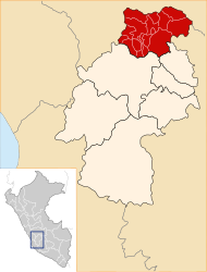
 The Quishuar district is located in the east of Tayacaja Province (marked in red) |
|
| Basic data | |
| Country | Peru |
| region | Huancavelica |
| province | Tayacaja |
| Seat | Quishuar |
| surface | 32.9 km² |
| Residents | 762 (2017) |
| density | 23 inhabitants per km² |
| founding | March 6, 1957 |
| ISO 3166-2 | PE-HUV |
| politics | |
| Alcalde District | Emiliano Carmen Bazán Ordóñez (2019-2022) |
| Political party | Movimiento Independiente Trabajando para Todos |
Coordinates: 12 ° 14 ′ 37 ″ S , 74 ° 46 ′ 38 ″ W.
The Quishuar District is located in the Tayacaja Province in the Huancavelica region in southwest central Peru . The district was established on March 6, 1957. It has an area of 32.9 km². The 2017 census counted 762 residents. In 1993 the population was 956, in 2007 it was 942. The district administration is located in the 3130 m high village of Quishuar with 674 inhabitants (as of 2017). Quishuar is located 20 km northeast of the provincial capital Pampas .
Geographical location
The Quishuar district is located in the Peruvian Central Cordillera in the east of the Tayacaja Province. The district is located on the left bank of the Río Mantaro below the confluence of the Río Huanchuy.
The Quishuar district borders the Surcubamba , Andaymarca and Daniel Hernández districts in the south . In the west, north and east, the Quishuar district is enclosed by the Salcabamba district .
Web links
- Peru: Huancavelica region (provinces and districts) at www.citypopulation.de
- INEI Perú