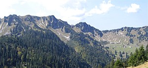
Rinnerspitz
| Rinnerspitz (Peißenberg) | ||
|---|---|---|
|
Rinnerspitz (right of the center of the picture) |
||
| height | 1611 m above sea level NN | |
| location | Bavaria , Germany | |
| Mountains | Schliersee Mountains | |
| Coordinates | 47 ° 40 ′ 29 " N , 11 ° 50 ′ 2" E | |
|
|
||
| rock | Main dolomite , plate limestone | |
| particularities | Place of death of Georg Jennerwein |
|
The Rinnerspitz , also called Peißenberg by the locals (not to be confused with the Hohen Peißenberg ), is a 1611 meter high peak in the Schlierseer Mountains in the Mangfall Mountains . Here, on November 6, 1877, the poacher Georg Jennerwein was shot from behind.
The Rinnerspitz lies between the summit of the 1,668 meter high Bodenschneid (430 meters southeast) and the 1,552 meter high water peak (653 meters north-northeast) in the southern district of Miesbach, like the neighboring peaks mentioned, exactly on the border between the communities of Rottach-Egern in the west and Schliersee in the Lie east. When ridge from the water spigot to Rinnerspitz, so on the northern flank of the summit, is the Jenner Wine memorial cross. The municipal boundary with these and other peaks marks the watershed between the Schliersee and the Tegernsee .
The DAV accommodation hut Bodenschneidhaus on the Rettenböckalm , 500 meters northeast of the Rinnerspitz, is the closest building. The closest village is the small hamlet Enterrottach (part of the municipality of Rottach-Egern), 1.3 km further west on the Valepp road , which is a toll road from the exit towards Valepp (south) . The Spitzingsee is a good three kilometers to the east and the border with Tyrol at Schinder is just under eight kilometers to the south (as the crow flies ).
Individual evidence
- ↑ On the trail of the poacher. In: merkur-online.de. Retrieved September 6, 2011 .
- ↑ Bottom cutting house. Hiking routes. Retrieved September 6, 2011 .
literature
- Alpine Club Card BY15, 2009 (1: 25,000)

