Rischbach (Mooslauter)
| Rischbach | ||
|
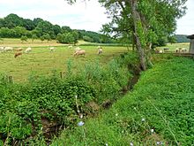
The Rischbach between Weilerbach and Erzenhausen |
||
| Data | ||
| Water code | DE : 2546684 | |
| location | Germany | |
| River system | Rhine | |
| Drain over | Mooslauter → Lauter → Glan → Nahe → Rhine → North Sea | |
| source | at Kollweiler 49 ° 30 ′ 53 ″ N , 7 ° 35 ′ 28 ″ E |
|
| Source height | 355 m above sea level NHN | |
| muzzle | near Weilerbach from the left into the Bruchbach Coordinates: 49 ° 29 '16 " N , 7 ° 39' 5" E 49 ° 29 '16 " N , 7 ° 39' 5" E |
|
| Mouth height | approx. 224 m above sea level NHN | |
| Height difference | approx. 131 m | |
| Bottom slope | approx. 22 ‰ | |
| length | 5.9 km | |
| Catchment area | 22.03 km² | |
The Rischbach is a 5.9 km long left tributary of the Mooslauter in Rhineland-Palatinate, which is still called Bruchbach in the upper reaches .
geography
course
The Rischbach rises in the North Palatinate Uplands on the eastern outskirts of Kollweiler in the area of the Gosenbergerhof district. It flows mainly in a south-easterly direction through the districts of the communities of Kollweiler, Schwedelbach , Erzenhausen , Weilerbach and Eulenbis . As the only localities it flows through the Schwedelbacher district Pörrbach and the Weilerbach hamlet Samuelshof. In the lower half of its course it forms the boundary between Erzenhausen and Schwedelbach, Erzenhausen and Weilerbach, as well as Eulenbis and Weilerbach. It flows directly at the Rodenbach / Weilerbach / Eulenbis triangle near the Rodenbach hamlet Mückenhof into the Bruchbach, which bears the name Mooslauter from the confluence with the Rischbach.
Tributaries
From the right, the Rischbach takes on the stream of the same name coming from Schwedelbach after 2.3 km, from the left after 4 km the Saubach from Erzenhausen and as the main tributary after 5.8 km just before its own confluence with the Bruchbach it takes the from the right Weilerbach coming up stream of the same name.
| Surname
|
location | Length in km |
EZG in km² |
Mouth height in m above sea level NHN |
GKZ |
|---|---|---|---|---|---|
| Schwedelbach | right | 1.3 | 5.6 | 249 | 2546684-12 |
| Saubach | Left | 3.5 | 4.7 | 232 | 2546684-2 |
| Weilerbach | right | 4.6 | 5.6 | 223 | 2546684-4 |
Notes on the table
- ↑ Water code number , in Germany the official river code number with a separator inserted after the prefix for better readability, which stands for the common receiving water Rischbach .
environment

Bioindicators
The Rischbach is counted as a biocoenic water type of fine material rich, carbonatic low mountain streams. The water structure quality in the lower reaches from Erzenhausen is indicated as strongly to very strongly changed, in the upper reaches as moderately to significantly changed. The water quality from Erzenhausen to the mouth is given as moderately polluted (as of 2005).
geology
The catchment area of Risch Bach is located in the northern part of the Palatine red sandstone area known as and is one geologically to Landstuhl break , the mountains north and northeast of the valley, like the Owl's Head (422 m), already belong to territorially typical of the North Palatine Uplands Permian sediments .
Land use
The Rischbach flows through an agricultural valley typical of the western Palatinate . Since there are only a few villages in its immediate vicinity, the valley is not very well developed in terms of traffic, the Rischbach is only bridged by a state road and three district roads .
natural reserve
In 1983, 14 hectares east of Erzenhausen above the Rischbach on the sinful slope of the Eulenkopf were designated as the Magerwiesen am Eulenkopf nature reserve, followed in 1987 by a 28 hectare area in the area of the confluence with the Mooslauter, east of Weilerbach , as the Krausenbruch nature reserve . Both nature reserves are part of the 3,150 hectare landscape protection area (LSG) "Eulenkopf und Umgebung" which was decided in 1977 . The LSG covers almost the entire catchment area of the Rischbach and other flowing waters around the Eulenkopf, to the northeast it extends to the Lauter .
Individual evidence
- ↑ a b [1] GPS geoplaner
- ↑ a b c d GeoExplorer of the Rhineland-Palatinate Water Management Authority ( information )

