Rissenthal
|
Rissenthal
Community Losheim am See
|
|
|---|---|
| Coordinates: 49 ° 28 ′ 0 ″ N , 6 ° 45 ′ 16 ″ E | |
| Height : | 244 (222–283) m above sea level NHN |
| Area : | 4.58 km² |
| Residents : | 668 (Oct 31, 2010) |
| Population density : | 146 inhabitants / km² |
| Incorporation : | 1st January 1974 |
| Postal code : | 66679 |
| Area code : | 06832 |
|
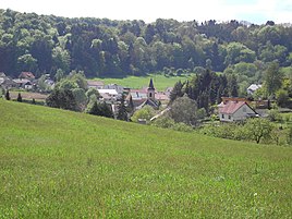
Rissenthal 2008
|
|
Rissenthal is a district of the municipality of Losheim am See in the Merzig-Wadern district ( Saarland ).
geography
Rissenthal is located on a southern branch of the Black Forest high forest , in a side valley of the Upper Hausstadt valley, south-southeast of the core of the Losheim community. The average altitude is 250 m above sea level. NHN . The heights surrounding the village reach the Schlädberg at 382 m above sea level. NHN the highest elevation. Geologically, Rissenthal belongs to the large Triassic region that stretches from central France across Lorraine between the Hunsrück , Hocheifel and Ardennes . Here you can mainly find red sandstone .
history
The place Rissenthal is mentioned for the first time in 1255. At that time, the manor over the area of the place was with the Archdiocese of Trier .
On January 1, 1974, the previously independent municipality of Rissenthal was incorporated into the municipality of Losheim.
In 2005 the place celebrated its 750th anniversary.
politics
Mayor
The current mayor of Rissenthal is Andreas Bossmann (SPD).
Former municipal coat of arms
- A red cross on silver: indication of former affiliation with Kurtrier .
- A silver cross on black: Reference to the earlier jurisdiction and hunting rights for the German lords - Beckingen Commandery .
- On green a cross and a fir tree in silver: reference to church and parish as well as to the forest and the meadow valley.
- Eight iron hats in blue on gold: reference to the lords of the castle of Esch / Lorraine (jurisdiction) and Dagstuhl (tithe tax). The iron hats are skins of the Siberian squirrel ( Feh ).
tourism
The 10.5 km long “Schluchtenpfad” circular hiking trail leads around the village. The moderately difficult path has a high proportion of paths consisting of ravines and ridge gorges.
Personalities
- Peter Wust (1884–1940), philosopher
Web links
Individual evidence
- ^ Federal Statistical Office (ed.): Historical municipality directory for the Federal Republic of Germany. Name, border and key number changes in municipalities, counties and administrative districts from May 27, 1970 to December 31, 1982 . W. Kohlhammer, Stuttgart / Mainz 1983, ISBN 3-17-003263-1 , p. 804 .
- ↑ www.tourismus.saarland.de ( Memento of the original from February 19, 2014 in the Internet Archive ) Info: The archive link was inserted automatically and has not yet been checked. Please check the original and archive link according to the instructions and then remove this notice.

