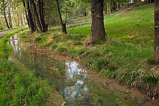
Roter Graben (Ore Mountains)
| Red moat | ||
|
Roter Graben near Tuttendorf |
||
| Data | ||
| location | Germany | |
| origin | as a branch from the ditch of the Middle Ratsmühle north of Halsbach 50 ° 55 ′ 39 ″ N , 13 ° 22 ′ 23 ″ E |
|
| muzzle | through culvert into the upper ditch west-northwest of Halsbrücke Coordinates: 50 ° 57 '29 " N , 13 ° 19' 48" E 50 ° 57 '29 " N , 13 ° 19' 48" E
|
|
| length | approx. 6.5 km | |
The Rote Graben is an artificial moat from the 17th century between Halsbach and Halsbrücke in the Ore Mountains . It was originally used to supply water for the mining of the Halsbrücker Spat .
course

The originally about 6.5 kilometers long ditch begins as a branch from the ditch of the Middle Ratsmühle north of Halsbach. It is fed by the water from the Freiberg Mulde . It then runs northwards with him on the west side of the river and first passes the Königl's mouth hole . Compatible company Stolln where he also takes water from this. A short distance further you will reach the mouth of the Thurmhof auxiliary tunnel , where water is also taken from the mine. Before Conradsdorf , the mouth of the main break in the Old Tiefen Fürstenstolln is passed and water is taken in again.
Then the ditch runs in a west-northwest direction to Tuttendorf , crosses the Tuttendorfer Dorfbach and a short distance further passes the Lower Ratsmühle , where water could be directed onto an overshot water wheel . Thereafter, the trench again runs in a northerly direction, passing the surcharge crispness of the pit Upper New screams and then reaches neck bridge. At the water distributor in Halsbrücke, part of the laundry was fed to the hut there. The other part continues to aid pit . Behind Halsbrücke, a loop of the Freiberg Mulde river is bypassed by the approximately 400-meter-long Halsbrückner Rösche . Before the Münzbach flows into the Freiberger Mulde, a culvert of the trench crosses it and then flows into the Upper Trench, which comes from the Münzbachtal .
history

via a rose
The Rote Graben was built from 1614 to 1615. Important tunnel mouth holes emerging in the Muldental, for example the Altes Tiefen Fürstenstolln, were tied into it. The ditch supplied water for the artificial tools and water gobs of the St. Johannes and St. Lorenz pits on the Halsbrücker Spat. Later, part of the energy was used for the Halsbrücke hut, which also had the Weiten Graben and the Hüttengraben .
additional
Its name is most likely derived from the phenomenon that iron oxide was washed out of the pits earlier and deposited as a fine red mud on the bottom.
The ditch has various cuts, partly considerable slope retaining walls and is partly blotted in the area of Halsbrücke. Today it is accompanied by a hiking trail.
Below the mouth of the Thurmhof auxiliary tunnel, the course of the trench, including its retaining walls, was completely torn away at around 150 meters as a result of the hollow flooding in August 2002. The section was reconstructed in 2003/2004. Retaining walls were newly erected or strengthened, the trench cross-section and the flow cross-section of the Freiberg Mulde widened.
Web links
- Photos at Panoramio.com: 1 , 2 , 3 , 4 , 5
- private homepage with picture description of the Red Trench
- Dieter Schräber: "Roter Graben" mining history exploration trail , Freiberg 2006 (pdf)
Individual evidence
- ↑ a b c Description in the "MontE" database of the Institute for Science and Technology History (IWTG) of the Technical University of Freiberg ( Memento of the original from January 21, 2016 in the Internet Archive ) Info: The archive link was inserted automatically and has not yet been checked. Please check the original and archive link according to the instructions and then remove this notice. , accessed August 16, 2010
- ↑ Federal Agency for Cartography and Geodesy , Staatsbetrieb Geobasisinformation und Vermessung Sachsen (GeoSN): Digital Topographical Map 1:50 000, Germany Viewer ( page no longer available , search in web archives ) Info: The link was automatically marked as defective. Please check the link according to the instructions and then remove this notice. (requires Java ), accessed February 27, 2013
- ↑ a b c Description of the Red Trench at www.unbekannter-bergbau.de , accessed on August 19, 2010
- ↑ Reconstruction of “Roter Graben” in the Freiberg district ( memento of the original from August 25, 2006 in the Internet Archive ) Info: The archive link was automatically inserted and not yet checked. Please check the original and archive link according to the instructions and then remove this notice. (PDF; 541 kB), accessed on August 19, 2010

