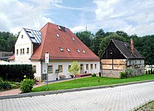
Halsbach (Freiberg)
|
Halsbach
Large district town Freiberg
Coordinates: 50 ° 55 ′ 20 ″ N , 13 ° 22 ′ 35 ″ E
|
||
|---|---|---|
| Residents : | 300 | |
| Incorporation : | 1st January 1979 | |
| Postal code : | 09599 | |
| Area code : | 03731 | |
|
Location of Halsbach in Saxony |
||
Halsbach is a district of the large district town Freiberg in the district of central Saxony (Free State of Saxony ). It was incorporated on January 1, 1979.
geography
location
Halsbach is the easternmost district of the city of Freiberg. It is located in the Eastern Ore Mountains on the eastern bank of the Freiberger Mulde . The districts of Neuhilbersdorf in the southern town hall and Kreuzermark in the eastern town hall belong to Halsbach .
Neighboring places
| Tuttendorf | Conradsdorf , Falkenberg | Naundorf |
| Freiberg, Freiberg-Ost district ( Himmelfahrter Revier district ) |

|
|
| Freiberg, Muldenhütten industrial area | Hilbersdorf |
history
Halsbach was mentioned in 1294 as "Habichsbach". The place flourished at the time of mining in Freiberg. Halsbach is a scattered settlement and its location on the Freiberg Mulde later favored it as an industrial area . The manorial rule over Halsbach lay with the Halsbach manor until the 19th century . Until 1856, Halsbach belonged to the Electoral Saxon or Royal Saxon District Office Freiberg . In 1856, Halsbach was affiliated to the Freiberg judicial office and in 1875 to the Freiberg district administration. Through the second district reform in the GDR , Halsbach came to the Freiberg district in the Chemnitz district in 1952 (renamed the Karl-Marx-Stadt district in 1953 ), which was continued as the Saxon district of Freiberg from 1990 and was added to the district of Central Saxony in 2008.
On January 1, 1979, Halsbach was incorporated into Freiberg. Since then it has formed the easternmost district of Freiberg.
traffic
The federal highway 173 runs in the south of Halsbach . There is a bus connection with the center of Freiberg.
economy
Types of industry
The industry located in Halsbach consisted for the most part of ore smelting, which further processed the ore that was mined in the Freiberg mining area. There were also ore washes that crushed the rock after it had been mined for melting. Several seam stands that supplied the smelters with coal were also important .
Today's meaning
Today, Halsbach is only one part of the city of Freiberg that is used as a residential area. With the loss of the importance of Freiberg silver ore, all smelters and similar buildings connected with silver mining were closed and most of them demolished by the end of the 18th century . More than 300 people live in Halsbach, mostly in their own homes. Today, Halsbach is mainly a hiking and forest area.
literature
- Halsbach . In: August Schumann : Complete State, Post and Newspaper Lexicon of Saxony. 3rd volume. Schumann, Zwickau 1816, p. 674 f.
Web links
- Halsbach in the Digital Historical Directory of Saxony
Individual evidence
- ↑ The Rittergut Halsbach on www.sachsens-schloesser.de
- ^ Karlheinz Blaschke , Uwe Ulrich Jäschke : Kursächsischer Ämteratlas. Leipzig 2009, ISBN 978-3-937386-14-0 ; P. 72 f.
- ^ The Amtshauptmannschaft Freiberg in the municipality register 1900
- ↑ Halsbach on gov.genealogy.net
- ^ The districts of Freiberg on the website of the city of Freiberg


