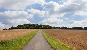
Saalberg (Barntrup)
| Saalberg | ||
|---|---|---|
| height | 342.9 m above sea level NN | |
| location | Barntrup , Lippe District , North Rhine-Westphalia , Germany | |
| Mountains | Lipper mountain country | |
| Coordinates | 52 ° 1 '14 " N , 9 ° 8' 24" E | |
|
|
||
| particularities | Windmill stump ( AT ) | |
The Saalberg (not to be confused with the nearby Saalberg near Aerzen ) is 342.9 m above sea level. NN high mountain of the Lipper mountains in the municipality of Barntrup in the North Rhine-Westphalian district of Lippe .
Geographical location
The Saalberg is close to the seam of the Lippe Uplands for eastern Weserbergland in the eastern part of the nature park Teutoburg Forest / Egge . It rises about 1.7 km southeast of the core of the Barntruper district Alverdissen , about 3.4 km north-northeast of the Barntruper core town and about 2.4 km northwest of the district Sonneborn .
The Saalberg is unforested and has an extensive sand-lime quarry west to north-west of the summit . Its northern foothills are called the Vorderer Saalberg ( 319.3 m above sea level ). About 4.4 km to the east, across the border with Lower Saxony, lies the Saalberg near Aerzen ( 266.4 m above sea level ).
Observation tower windmill stump
On the gently sloping southern flank of the Saalberg, around 1.7 km south-south-east of its summit and just under 1.6 km west-south-west of the village of Sonneborn, there has been a windmill since the beginning of the 18th century (approx. 315 m above sea level ; ⊙ ), as evidenced in 1869 was in operation. There, once harvested grain was ground, which had to be carted from the surrounding villages with great effort. Business decline gradually followed - certainly because of the poor road conditions. The mill fire of 1882 is documented; the mill was not rebuilt. In 1928 their ruins were converted into a lookout tower - called the windmill stump and also called the windmill pot.
From the freely accessible viewing platform at about 330 m above sea level. NN the view falls among other things on Barntrup, in the Lipper Bergland and therein into the Bega and Humme valley and the Hohe Asch . The Weserbergland in the northeast, the Köterberg in the southeast and the Teutoburg Forest with the Hermannsdenkmal and the Egge Mountains adjoining it to the south can be seen in the distance. On days with good visibility, the view extends to the east as far as the Brocken ( 1141.1 m above sea level ) in the Harz Mountains .
Protected area and wind power
On the Saalberg there are several wind turbines to the east above the sand-lime quarry . The 9.37 km² nature reserve Biotopkomplex am Mühlenturm (NSG no. 378160) is located at the observation tower, founded in 2007 .
Traffic and walking
To the west, past the Saalberg, beyond the sand-lime quarry from Alverdissen in the north to Barntrup in the south, the state road 758, which meets the federal road 66 in Barntrup , which in turn connects to the federal road 1 leading northeast to Sonneborn . Several roads and dirt roads lead from the above-mentioned towns up to the mountain and past the observation tower.
Along the L 758 passing Extertalbahn and along the B 66 and B 1 ran from Barntrup northeast on Sonneborn the Lower Saxony Aerzen up to its final closure (1994) bearing track as part of the west that are still in operation railway line Bielefeld-Hameln ; The tracks have long been removed and the route is now laid out as a cycle path - warehouse Bahnweg .
The 106 km long Dingelstedt Path and the 11 km long Dwarf Anton Tour lead over the mountain and past the observation tower .
Web links
Individual evidence
- ↑ a b Topographical Information Management, Cologne District Government, Department GEObasis NRW ( Notes )
- ↑ a b c d e Information with watercolor on the observation tower Windmühlenstumpf / -pott on teutoburger-maerchen-wald.de
- ↑ a b Information on the Zwerg-Anton-Tour with photos also on the observation tower Windmühlenstumpf / -pott on teutoburger-maerchen-wald.de
- ↑ Map services of the Federal Agency for Nature Conservation ( information )


