
Saint-Eustache (Québec)
| Saint-Eustache | |||
|---|---|---|---|
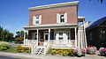
 Town hall of Saint-Eustache |
|||
| Location in Quebec | |||
|
|||
| State : |
|
||
| Province : | Quebec | ||
| Administrative region : | Laurentides | ||
| MRC or equivalent : | Deux-Montagnes | ||
| Coordinates : | 45 ° 34 ′ N , 73 ° 54 ′ W | ||
| Height : | 28 m | ||
| Area : | 69.61 km² | ||
| Residents : | 44,154 (as of 2011) | ||
| Population density : | 634.3 inhabitants / km² | ||
| Time zone : | Eastern Time ( UTC − 5 ) | ||
| Municipality number: | 72005 | ||
| Postal code : | J7R | ||
| Area code : | +1 450 | ||
| Mayor : | Pierre Charron | ||
| Website : | www.ville.saint-eustache.qc.ca | ||
 Located in the MRC Deux-Montagnes |
|||

Saint-Eustache is a city in the southwest of the Canadian province of Québec . It is located in the Laurentides administrative region , around 30 km west of Montreal . Saint-Eustache belongs to the regional county municipality (municipalité régionale du comté) Deux-Montagnes , has an area of 69.61 km² and has 44,154 inhabitants (2011).
geography
Saint-Eustache is located in the Rive-Nord region on the west bank of the Rivière des Mille Îles , one of the estuary of the Ottawa . This has several islands in the northeastern part of the urban area; these include the Île Norbert-Aubé, the Île Yale, the Île Corbeil, the Île Maurice and the Île Provost. On the opposite side of the river is the Île Jésus . On the southern outskirts of the city, the Rivière du Chêne flows into the Rivière des Mille Îles. Neighboring communities are Mirabel in the north, Boisbriand in the north-east, Laval in the east, Deux-Montagnes and Sainte-Marthe-sur-le-Lac in the south and Saint-Joseph-du-Lac in the west.
history
Michel Sidrac Dugué de Boisbriand was awarded the Seigneurie on the Rivière des Mille Îles in 1683 , but neither he nor his descendants were interested in developing the area. This only changed when Eustache Lambert Dumont took over the Seigneurie in 1749. His son Eustache-Louis Dumont, who settled colonists at the mouth of the Rivière du Chêne from 1760 onwards, is considered to be the actual founder of the city . Shortly thereafter, a flour mill was also built. The settlement was named after its patron saint, Saint Eustachius . In 1768 the parish was founded, the parish church was built between 1780 and 1783.

Around 1790, Saint-Eustache was the fifth largest settlement in Lower Canada with a population of almost 2,400 ; in 1825 the population had already grown to over 4,300. The first bridge over the Rivière des Mille Îles over to the Île Jésus was built in 1830. During the Lower Canada rebellion on December 14, 1837, around 200 rebels led by Jean-Olivier Chénier holed up in the church and offered bitter resistance against the colonial troops the leadership of John Colborne ; the battle of Saint-Eustache claimed 73 lives. A year after the abolition of the manor, the municipality of Saint-Eustache was founded in 1855.
From the 1860s to the 1940s, the population remained largely stable, as the community was predominantly agricultural and hardly any industry settled. The opening of a branch line of the Canadian Pacific Railway from Sainte-Thérèse to Saint-Eustache on June 26, 1882 did little to change that, since the railway line was mainly used to transport agricultural products; the railway line was finally shut down on April 27, 1940. In 1921 the new municipality of Saint-Eustache-sur-le-Lac was split off (today's city of Deux-Montagnes ), and Sainte-Marthe-sur-le-Lac was founded in 1960 through a further cession . Regardless of this, Saint-Eustache received city status in 1948.
The opening of the new Pont Arthur-Sauvé and, above all, the construction of the motorway from the 1960s onwards led to a rapid increase in population. The previously rural Saint-Eustache developed into a suburb on the edge of the Montreal / Laval metropolitan area. The Congrégation de Notre-Dame de Montréal , a religious order of nuns, sold their monastery (built in 1898) to the city administration in 1986, which has since used the building as a town hall. Saint-Eustache is a member of the Communauté métropolitaine de Montréal association founded in 2000 .
population
According to the 2011 census, Saint-Eustache had 44,154 inhabitants, which corresponds to a population density of 634.3 inh / km². 90.7% of the population stated French as their main language, while English accounted for 3.7%. 0.8% said they were bilingual (French and English), 4.8% made use of other languages and multiple answers. Only French spoke 51.4%. In 2001, 92.8% of the population were Roman Catholic , 2.1% Protestant and 3.9% non-denominational.
Transport and economy
The main road link is Autoroute 13 , the freeway leading here from Montreal and Laval . It meets Autoroute 640 on the northern outskirts of Saint-Eustache . This begins in the neighboring municipality of Sainte-Marthe-sur-le-Lac , bypasses the agglomeration in the north and ends at Repentigny . The main road Route 148 runs through the city center between Laval and Gatineau ; it crosses the river on the Pont Arthur-Sauvé . The Agence métropolitaine de transport (AMT) operates the terminus Saint-Eustache on Boulevard Arthur-Sauvé . This bus station is the junction of several bus routes operated by the CIT Laurentides and Société de transport de Laval companies . Buses run to the city of Laval and the Deux-Montagnes train station (connection to the AMT suburban trains to Montreal).
Due to its location between the Montreal / Laval metropolitan area and an important agricultural region to the west of it, the food industry in Saint-Eustache is of great importance. The best-known industrial company based in Saint-Eustache is Nova Bus , a Volvo subsidiary specializing in the production of buses .
Attractions
The town's landmark is the Saint-Eustache church, built in 1783 in neoclassical style. A special feature of this building are several bullet holes in the facade; these come from cannonballs that were fired at the rebels entrenched in the building in 1837. Several buildings from the 18th and 19th centuries have also been preserved. These include the Manoir Globensky ( August Franz Globensky's home ), the former Notre-Dame monastery (today's town hall) and the Moulin Légaré (Canada's oldest hydropower-powered flour mill).
Sports
To the northwest of the city is the Saint-Eustache Autodrome . On this motorsport race to drag race and race in the Whelen All-American Series and the NASCAR Canadian Tire Series performed.
Personalities
- Hugo Boisvert (* 1976), ice hockey player
- Alexis Lafrenière (* 2001), ice hockey player
- Guylaine St-Onge (1965–2005), actress
photos

Saint-Eustache church
Maison Lavigne-Richer
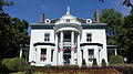
Manoir Globensky

Maison Chenier-Sauvé

Moulin Legaré


Web links
- Official website of Saint-Eustache (French)
Individual evidence
- ↑ Saint-Eustache. Commission de toponymie du Québec, accessed January 3, 2014 (French).
- ↑ Histoire / les racines. City of Saint-Eustache, accessed January 3, 2014 (French).
- ↑ Histoire / la paroisse. (No longer available online.) City of Saint-Eustache, archived from the original on January 3, 2014 ; Retrieved January 3, 2014 (French). Info: The archive link was inserted automatically and has not yet been checked. Please check the original and archive link according to the instructions and then remove this notice.
- ^ Histoire / le village. City of Saint-Eustache, accessed January 3, 2014 (French).
- ↑ Histoire / la ville. City of Saint-Eustache, accessed January 3, 2014 (French).
- ↑ Population profile of the commune of Saint-Eustache. In: 2011 Census. Statistics Canada , 2011, accessed January 3, 2014 (French).
- ↑ Population profile of the commune of Saint-Eustache. In: 2001 Census. Statistics Canada , 2001, accessed January 3, 2014 (French).
- ↑ Portrait. City of Saint-Eustache, accessed January 3, 2014 (French).
- ^ Église de Saint-Eustache. Répertoire du patrimoine culturel du Québec, 2013, accessed on January 3, 2014 (French).